
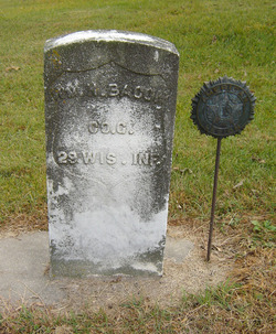
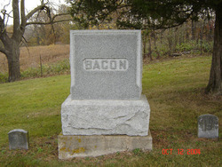
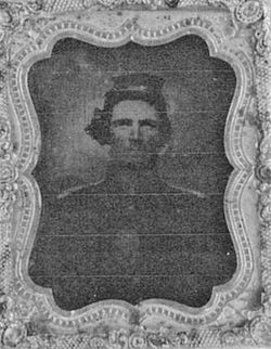
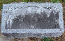
William H. Bacon
| Birth | : | 1845 |
| Death | : | 19 Sep 1910 Clayton County, Iowa, USA |
| Burial | : | Friedhof Biberist, Biberist, Bezirk Wasseramt, Switzerland |
| Coordinate | : | 47.1841058, 7.5591500 |
| Description | : | Son of Oran & Polly Bacon. Married Louisa Franklin, father of Wm E. Bacon. |
frequently asked questions (FAQ):
-
Where is William H. Bacon's memorial?
William H. Bacon's memorial is located at: Friedhof Biberist, Biberist, Bezirk Wasseramt, Switzerland.
-
When did William H. Bacon death?
William H. Bacon death on 19 Sep 1910 in Clayton County, Iowa, USA
-
Where are the coordinates of the William H. Bacon's memorial?
Latitude: 47.1841058
Longitude: 7.5591500
Family Members:
Parent
Siblings
Children


Nearby Cemetories:
1. Friedhof Biberist
Biberist, Bezirk Wasseramt, Switzerland
Coordinate: 47.1841058, 7.5591500
2. Friedhof Gerlafingen
Gerlafingen, Bezirk Wasseramt, Switzerland
Coordinate: 47.1721956, 7.5748746
3. Gemeindefriedhof Derendingen
Derendingen, Bezirk Wasseramt, Switzerland
Coordinate: 47.1963030, 7.5875510
4. Gemeindefriedhof Kriegstetten
Kriegstetten, Bezirk Wasseramt, Switzerland
Coordinate: 47.1764700, 7.5985800
5. Friedhof St. Katharinen in Solothurn
Solothurn, Bezirk Solothurn, Switzerland
Coordinate: 47.2187212, 7.5459221
6. Friedhof St.Niklaus
Feldbrunnen, Bezirk Lebern, Switzerland
Coordinate: 47.2209648, 7.5439568
7. Gemeindefriedhof Deitingen SO
Deitingen, Bezirk Wasseramt, Switzerland
Coordinate: 47.2107720, 7.6192680
8. Friedhof Selzach
Selzach, Bezirk Lebern, Switzerland
Coordinate: 47.2069805, 7.4578557
9. Friedhof Seeberg
Seeberg, Verwaltungskreis Oberaargau, Switzerland
Coordinate: 47.1587959, 7.6703613
10. Friedhof Wangen an der Aare
Wangen an der Aare, Verwaltungskreis Oberaargau, Switzerland
Coordinate: 47.2352419, 7.6585167
11. Friedhof Wiedlisbach
Wiedlisbach, Verwaltungskreis Oberaargau, Switzerland
Coordinate: 47.2488811, 7.6414128
12. Friedhof Welschenrohr
Welschenrohr, Bezirk Thal, Switzerland
Coordinate: 47.2826744, 7.5296148
13. Friedhof Herzogenbuchsee
Herzogenbuchsee, Verwaltungskreis Oberaargau, Switzerland
Coordinate: 47.1942000, 7.7102000
14. Friedhof Oberbipp
Oberbipp, Verwaltungskreis Oberaargau, Switzerland
Coordinate: 47.2633610, 7.6605863
15. Friedhof Wynigen
Wynigen, Verwaltungskreis Emmental, Switzerland
Coordinate: 47.1048300, 7.6666800
16. Friedhof Thörigen
Thörigen, Verwaltungskreis Oberaargau, Switzerland
Coordinate: 47.1701665, 7.7231642
17. Friedhof Oschwand
Oschwand, Verwaltungskreis Oberaargau, Switzerland
Coordinate: 47.1416000, 7.7134200
18. Friedhof Neuhaus und Oschwand
Ochlenberg, Verwaltungskreis Oberaargau, Switzerland
Coordinate: 47.1415500, 7.7135000
19. Friedhof Grenchen
Grenchen, Bezirk Lebern, Switzerland
Coordinate: 47.1919012, 7.3841961
20. Friedhof Niederbipp
Niederbipp, Verwaltungskreis Oberaargau, Switzerland
Coordinate: 47.2654200, 7.6918410
21. Friedhof Bannwil
Bannwil, Verwaltungskreis Oberaargau, Switzerland
Coordinate: 47.2372302, 7.7318282
22. Friedhof Thunstetten
Thunstetten, Verwaltungskreis Oberaargau, Switzerland
Coordinate: 47.2039799, 7.7527511
23. Friedhof Burgdorf
Burgdorf, Verwaltungskreis Emmental, Switzerland
Coordinate: 47.0550300, 7.6117800
24. Friedhof Bleienbach
Bleienbach, Verwaltungskreis Oberaargau, Switzerland
Coordinate: 47.1843989, 7.7594101