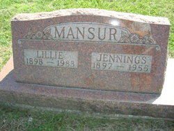
William Jennings Mansur
| Birth | : | 23 Jan 1897 Stet, Ray County, Missouri, USA |
| Death | : | 17 Aug 1955 Grape Grove Township, Ray County, Missouri, USA |
| Burial | : | Northland Cemetery, Ransom County, USA |
| Coordinate | : | 46.5888630, -97.9510010 |
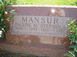
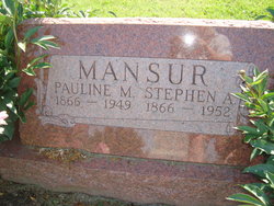
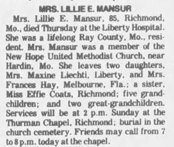
| Description | : | MO Death Cert # 27315 Father = Steve Allen Mansur Mother = Pauline Bowen Spouse = Lillie Coates Informant = Mrs. Jennings Mansur Occupation = Farmer COD = Cancer |
frequently asked questions (FAQ):
-
Where is William Jennings Mansur's memorial?
William Jennings Mansur's memorial is located at: Northland Cemetery, Ransom County, USA.
-
When did William Jennings Mansur death?
William Jennings Mansur death on 17 Aug 1955 in Grape Grove Township, Ray County, Missouri, USA
-
Where are the coordinates of the William Jennings Mansur's memorial?
Latitude: 46.5888630
Longitude: -97.9510010
Family Members:
Parent
Spouse
Siblings
Children
Flowers:
Nearby Cemetories:
1. Northland Cemetery
Ransom County, USA
Coordinate: 46.5888630, -97.9510010
2. Preston Cemetery
Fort Ransom, Ransom County, USA
Coordinate: 46.5771830, -97.8888170
3. Nordheim Cemetery
Ransom County, USA
Coordinate: 46.6240800, -97.9922100
4. Standing Rock Cemetery
Fort Ransom, Ransom County, USA
Coordinate: 46.5435982, -97.9467010
5. Fort Ransom Post Cemetery
Fort Ransom, Ransom County, USA
Coordinate: 46.5176930, -97.9399920
6. Waldheim Cemetery
Kathryn, Barnes County, USA
Coordinate: 46.6668600, -97.9348100
7. Stiklestad Cemetery
Fort Ransom, Ransom County, USA
Coordinate: 46.4996986, -97.9617004
8. North Lamoure Cemetery
LaMoure, LaMoure County, USA
Coordinate: 46.5729027, -98.0887604
9. Bethania Cemetery
Ransom County, USA
Coordinate: 46.5433660, -97.8270290
10. Saint Pauls Cemetery
Kathryn, Barnes County, USA
Coordinate: 46.6883011, -97.9875031
11. Saint Petri Cemetery
Nome, Barnes County, USA
Coordinate: 46.6597500, -97.8281100
12. North Lamoure Pioneer Cemetery
LaMoure County, USA
Coordinate: 46.6160300, -98.1182300
13. Fillmore Cemetery
Enderlin, Ransom County, USA
Coordinate: 46.5870820, -97.7605000
14. Sjulli Cemetery
LaMoure County, USA
Coordinate: 46.5203018, -98.1177979
15. Spring Creek Cemetery
Barnes County, USA
Coordinate: 46.6893997, -98.0919037
16. West Fairview Cemetery
Ransom County, USA
Coordinate: 46.4533005, -98.0128021
17. Swedish Cemetery
Litchville, Barnes County, USA
Coordinate: 46.6453018, -98.1449966
18. Sheyenne Valley Cemetery
Kathryn, Barnes County, USA
Coordinate: 46.7324100, -97.9815000
19. Sunnyside Cemetery
Hastings, Barnes County, USA
Coordinate: 46.7223100, -98.0394300
20. Immanuel Lutheran Cemetery
Fingal, Barnes County, USA
Coordinate: 46.7421150, -97.8715057
21. Litchville Cemetery
LaMoure County, USA
Coordinate: 46.6007600, -98.1905700
22. Griswold Cemetery
LaMoure County, USA
Coordinate: 46.5727997, -98.2058029
23. Lucca Congregational Cemetery
Lucca, Barnes County, USA
Coordinate: 46.7085300, -97.7205300
24. Saint Anns Cemetery
Litchville, Barnes County, USA
Coordinate: 46.6453018, -98.2281036

