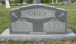
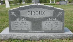
William Leonidas “Bill” Giroux
| Birth | : | 31 Mar 1880 Bromptonville, Estrie Region, Quebec, Canada |
| Death | : | 27 Mar 1962 Cloud County, Kansas, USA |
| Burial | : | Resthaven Memorial Park, Rock Creek Township, Pottawatomie County, USA |
| Coordinate | : | 35.3316994, -96.8636017 |
| Plot | : | Block 33.32 |
| Inscription | : | Married Jan. 31, 1905 |
| Description | : | Blade Empire-Mar. 28, 1962 Bill Giroux was born March 31, 1880 in Bromptonville, Canada the son of Mr. and Mrs. Henri Giroux. He was married at Bromptonville to Eva Marie Peltier on Jan. 31, 1905. They came to Cloud County in 1906 and settled on a farm in Buffalo Township. They lived and farmed there until he retired in 1944 when they moved to Concordia. He was a member of the Catholic Church and an honorary member of the Knights of Columbus. He was a right-of-way purchasing agent for the Kansas State Highway commission in Topeka... Read More |
frequently asked questions (FAQ):
-
Where is William Leonidas “Bill” Giroux's memorial?
William Leonidas “Bill” Giroux's memorial is located at: Resthaven Memorial Park, Rock Creek Township, Pottawatomie County, USA.
-
When did William Leonidas “Bill” Giroux death?
William Leonidas “Bill” Giroux death on 27 Mar 1962 in Cloud County, Kansas, USA
-
Where are the coordinates of the William Leonidas “Bill” Giroux's memorial?
Latitude: 35.3316994
Longitude: -96.8636017
Family Members:
Spouse
Children
Flowers:
Nearby Cemetories:
1. Resthaven Memorial Park
Rock Creek Township, Pottawatomie County, USA
Coordinate: 35.3316994, -96.8636017
2. Fairview Cemetery
Shawnee, Pottawatomie County, USA
Coordinate: 35.3436300, -96.9078400
3. Emmanuel Episcopal Church Columbarium
Shawnee, Pottawatomie County, USA
Coordinate: 35.3327000, -96.9235000
4. Neal Cemetery
Earlsboro, Pottawatomie County, USA
Coordinate: 35.3260994, -96.7885971
5. Citizen Potawatomi Nation Cemetery
Shawnee, Pottawatomie County, USA
Coordinate: 35.2979180, -96.9292110
6. Tecumseh Cemetery
Tecumseh, Pottawatomie County, USA
Coordinate: 35.2927800, -96.9263200
7. Earlsboro Cemetery
Earlsboro, Pottawatomie County, USA
Coordinate: 35.2832260, -96.8070000
8. Longhorn Family Cemetery
Shawnee, Pottawatomie County, USA
Coordinate: 35.3998900, -96.8594600
9. Bently-Walker Family Cemetery
Shawnee, Pottawatomie County, USA
Coordinate: 35.3996000, -96.8814000
10. Alford Family Cemetery
Pottawatomie County, USA
Coordinate: 35.4053000, -96.8588000
11. Earlsboro Cemetery
Earlsboro, Pottawatomie County, USA
Coordinate: 35.2752000, -96.8056000
12. Johnson Cemetery
Econtuchka, Pottawatomie County, USA
Coordinate: 35.4055000, -96.8428000
13. Calvary Cemetery
Shawnee, Pottawatomie County, USA
Coordinate: 35.3509760, -96.9595490
14. Saint Gregory's Abbey Cemetery
Shawnee, Pottawatomie County, USA
Coordinate: 35.3669440, -96.9532800
15. Switch Family Cemetery
Shawnee, Pottawatomie County, USA
Coordinate: 35.4201470, -96.8592600
16. Wakolee Cemetery
Johnson, Pottawatomie County, USA
Coordinate: 35.4239006, -96.8735962
17. Old Dance Ground Cemetery
Pottawatomie County, USA
Coordinate: 35.4262000, -96.8949000
18. Harjo Underwood Family Cemetery
Harjo, Pottawatomie County, USA
Coordinate: 35.2311000, -96.8577000
19. Joe Nadeau Family Cemetery
Earlsboro, Pottawatomie County, USA
Coordinate: 35.2463939, -96.7897261
20. Forest Hill Cemetery
Tecumseh, Pottawatomie County, USA
Coordinate: 35.2282982, -96.8938980
21. McKosta Cemetery
Pottawatomie County, USA
Coordinate: 35.4225006, -96.7928009
22. Sangster Family Cemetery
Harjo, Pottawatomie County, USA
Coordinate: 35.2315210, -96.8013080
23. Union Cemetery
Earlsboro, Pottawatomie County, USA
Coordinate: 35.2308006, -96.7996979
24. Clark-Squire Family Cemetery
Shawnee, Pottawatomie County, USA
Coordinate: 35.4097600, -96.9684200

