William Preston Bourne
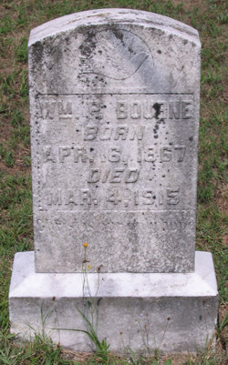
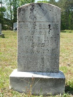
| Birth | : | 16 Apr 1867 Grayson County, Virginia, USA |
| Death | : | 4 Mar 1915 |
| Burial | : | Bridgeton Township Cemetery, Bridgeton, Newaygo County, USA |
| Coordinate | : | 43.3416670, -85.9352700 |
| Plot | : | #69 |
| Inscription | : | Christ is our only hope. |
| Description | : | Son of J.L. and Jane Bourne. Married R.C. Byrd on 19.Jun.1892, Grayson County, Virginia. In 1900, William (age 33) & Rosa (age 32) lived in the Old Town District, Grayson Co, VA. Rosa had born 3 children, 2 of whom survived; Margie (age 7) and Archie (age 3). Archie married Zela Taylor on 03 Dec 1921, Danville, VA. Disinterment from the Whites Chapel Church Cemetery, Dinwiddie County during the 1941-42 expansion of Fort Pickett. Source; Fort Pickett Historic Cemeteries Brunswick, Dinwiddie & Nottoway Counties, VA Fort Pickett Cultural Resource Management Project 2005.06 Prepared by; Conservation Management Institute VA Polytechnic Institute & State University Cultural Resources Program 200... Read More |
frequently asked questions (FAQ):
-
Where is William Preston Bourne's memorial?
William Preston Bourne's memorial is located at: Bridgeton Township Cemetery, Bridgeton, Newaygo County, USA.
-
When did William Preston Bourne death?
William Preston Bourne death on 4 Mar 1915 in
-
Where are the coordinates of the William Preston Bourne's memorial?
Latitude: 43.3416670
Longitude: -85.9352700
Family Members:
Parent
Spouse
Siblings
Flowers:
Nearby Cemetories:
1. Bridgeton Township Cemetery
Bridgeton, Newaygo County, USA
Coordinate: 43.3416670, -85.9352700
2. Peaceful Pines Cemetery
Fremont, Newaygo County, USA
Coordinate: 43.3799240, -85.9639040
3. Indian Cemetery
Fremont, Newaygo County, USA
Coordinate: 43.3302780, -86.0094440
4. Shippy Cemetery
Ashland, Newaygo County, USA
Coordinate: 43.3069000, -85.8743973
5. Ashland Center Cemetery
Grant, Newaygo County, USA
Coordinate: 43.3340000, -85.8390000
6. Sitka Cemetery
Bridgeton Township, Newaygo County, USA
Coordinate: 43.3783330, -86.0183330
7. Chidester Cemetery
Moorland, Muskegon County, USA
Coordinate: 43.2891998, -86.0085983
8. Saint Anthonys Cemetery
Cedar Creek Township, Muskegon County, USA
Coordinate: 43.3258018, -86.0441971
9. Seaman Cemetery
Casnovia, Muskegon County, USA
Coordinate: 43.2827988, -85.8482971
10. Johnson Cemetery
Twin Lake, Muskegon County, USA
Coordinate: 43.3516585, -86.0583279
11. Danish Lutheran Cemetery
Ashland, Newaygo County, USA
Coordinate: 43.3222200, -85.8141700
12. Parkview Cemetery
Grant, Newaygo County, USA
Coordinate: 43.3360000, -85.8013370
13. Garfield Township Cemetery
Newaygo, Newaygo County, USA
Coordinate: 43.4257400, -85.8601410
14. Reeman Cemetery
Reeman, Newaygo County, USA
Coordinate: 43.4350014, -85.9906006
15. Holton Evangelical Lutheran Cemetery
Holton, Muskegon County, USA
Coordinate: 43.3911300, -86.0586700
16. Mount Calvary Cemetery
Fremont, Newaygo County, USA
Coordinate: 43.4555600, -85.9747200
17. Maple Grove Cemetery
Fremont, Newaygo County, USA
Coordinate: 43.4597200, -85.9450000
18. Bell Place Cemetery
Ravenna, Muskegon County, USA
Coordinate: 43.2286987, -85.8797989
19. Fremont United Methodist Church Memorial Garden
Fremont, Newaygo County, USA
Coordinate: 43.4629240, -85.9377360
20. Saint Michaels Cemetery
Brunswick, Newaygo County, USA
Coordinate: 43.4385986, -86.0378036
21. Saint Bartholomew Catholic Cemetery
Newaygo, Newaygo County, USA
Coordinate: 43.4238610, -85.8101750
22. Pioneer Cemetery
Fremont, Newaygo County, USA
Coordinate: 43.4667710, -85.9300380
23. Newaygo County Poor Farm Cemetery
Fremont, Newaygo County, USA
Coordinate: 43.4672220, -85.9133330
24. Holton Cemetery
Holton, Muskegon County, USA
Coordinate: 43.4099030, -86.0830520

