William Sherman Sells
| Birth | : | 28 Aug 1919 New Hartford, Butler County, Iowa, USA |
| Death | : | 30 Nov 2003 Hampton, Franklin County, Iowa, USA |
| Burial | : | Russell Cemetery, Craigsville, Nicholas County, USA |
| Coordinate | : | 38.2957993, -80.6600037 |
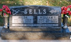
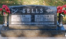
| Description | : | William "Bill" Sells, age 84, of Hampton, Iowa and formerly of Clarksville, Iowa, was born August 28, 1919, in New Hartford, Iowa, the son of William and Emma Jane Ackerson Sells. He received his education in the New Hartford school. Bill was united in marriage with Hilda DeGroote on April 10, 1941, in Albert Lea, Minnesota. The couple first lived in Waterloo, where he worked at Rath Packing Co. and John Deere Tractor Co. They later moved to New Hartford and Clarksville. Bill had operated his own TV repair shop and worked with Walter Perkins in Clarksville. He worked at... Read More |
frequently asked questions (FAQ):
-
Where is William Sherman Sells's memorial?
William Sherman Sells's memorial is located at: Russell Cemetery, Craigsville, Nicholas County, USA.
-
When did William Sherman Sells death?
William Sherman Sells death on 30 Nov 2003 in Hampton, Franklin County, Iowa, USA
-
Where are the coordinates of the William Sherman Sells's memorial?
Latitude: 38.2957993
Longitude: -80.6600037
Family Members:
Spouse
Siblings
Children
Flowers:
Nearby Cemetories:
1. Russell Cemetery
Craigsville, Nicholas County, USA
Coordinate: 38.2957993, -80.6600037
2. Buckle Cemetery
Craigsville, Nicholas County, USA
Coordinate: 38.2960720, -80.6596530
3. Curtin Cemetery
Nicholas County, USA
Coordinate: 38.2809982, -80.6334991
4. Creasy Cemetery
Beaver, Nicholas County, USA
Coordinate: 38.3279050, -80.6656340
5. Alderson Baptist Church Cemetery
Nicholas County, USA
Coordinate: 38.3268950, -80.6735940
6. Craigsville Cemetery
Craigsville, Nicholas County, USA
Coordinate: 38.3325080, -80.6548930
7. Mountain Trail Memorial Cemetery
Craigsville, Nicholas County, USA
Coordinate: 38.3143997, -80.6138992
8. Ward Road Cemetery
Nettie, Nicholas County, USA
Coordinate: 38.2738991, -80.7080994
9. Joseph Bryant Cemetery
Canvas, Nicholas County, USA
Coordinate: 38.2667496, -80.7143602
10. Powers Cemetery
Nicholas County, USA
Coordinate: 38.3372002, -80.6183090
11. Taylor Cemetery
Fenwick, Nicholas County, USA
Coordinate: 38.2510986, -80.6149979
12. Denna Cemetery
Richwood, Nicholas County, USA
Coordinate: 38.2773300, -80.5860500
13. West Virginia Memorial Gardens
Calvin, Nicholas County, USA
Coordinate: 38.3391370, -80.7150840
14. Fleming's Cemetery
Cottle, Nicholas County, USA
Coordinate: 38.3518867, -80.6141968
15. Little Union Church Cemetery
Calvin, Nicholas County, USA
Coordinate: 38.3442700, -80.7237000
16. Mullens Cemetery
Calvin, Nicholas County, USA
Coordinate: 38.3574982, -80.7052994
17. Downtain Chapel Cemetery
Nettie, Nicholas County, USA
Coordinate: 38.2307500, -80.7013300
18. Lambert Cemetery
Nicholas County, USA
Coordinate: 38.3683014, -80.6793976
19. Harrison Groves Family Cemetery
Canvas, Nicholas County, USA
Coordinate: 38.2838650, -80.7539100
20. Olive Branch Baptist Church Cemetery
Nettie, Nicholas County, USA
Coordinate: 38.2209464, -80.6862029
21. Blacks Chapel Cemetery
Camden on Gauley, Webster County, USA
Coordinate: 38.3668709, -80.6162567
22. Jake Hinkle Cemetery
Camden on Gauley, Webster County, USA
Coordinate: 38.3531570, -80.5876160
23. Hubbard Cemetery
Richwood, Nicholas County, USA
Coordinate: 38.2609711, -80.5657196
24. Russell Cemetery
Coe, Nicholas County, USA
Coordinate: 38.3304800, -80.5629300

