
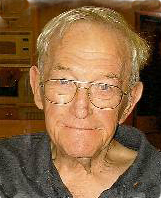
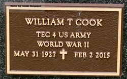
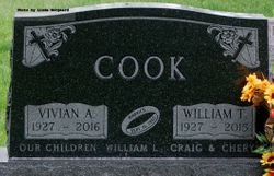
William T. “Bill” Cook
| Birth | : | 31 May 1927 Sioux Falls, Minnehaha County, South Dakota, USA |
| Death | : | 2 Feb 2015 Northfield, Rice County, Minnesota, USA |
| Burial | : | Riverside Cemetery, Spencer, Clay County, USA |
| Coordinate | : | 43.1441994, -95.1671982 |
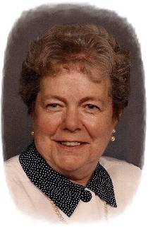
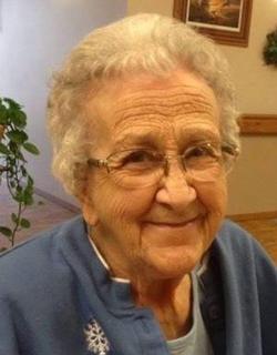
| Description | : | William "Bill" Cook, the son of Oscar and Kathryn (Smith) Cook, was born May 31, 1927 in Sioux Falls, SD. His childhood years were spent in Sioux Falls, where he received his early education later graduating from Sioux Falls Washington High School. Bill entered the military and served his country during WWII from 1945 until his honorable discharge in 1946. After his discharge, he continued his education at South Dakota State University in Brookings, SD and later attended graduate school at SDSU. Bill married Vivian Julson on September 16, 1950 in Sioux Falls, SD. Bill taught school in the communities of... Read More |
frequently asked questions (FAQ):
-
Where is William T. “Bill” Cook's memorial?
William T. “Bill” Cook's memorial is located at: Riverside Cemetery, Spencer, Clay County, USA.
-
When did William T. “Bill” Cook death?
William T. “Bill” Cook death on 2 Feb 2015 in Northfield, Rice County, Minnesota, USA
-
Where are the coordinates of the William T. “Bill” Cook's memorial?
Latitude: 43.1441994
Longitude: -95.1671982
Family Members:
Parent

Spouse
Siblings
Flowers:


Nearby Cemetories:
1. Riverside Cemetery
Spencer, Clay County, USA
Coordinate: 43.1441994, -95.1671982
2. Dewey Readmore Books Memorial
Spencer, Clay County, USA
Coordinate: 43.1403999, -95.1443024
3. North Lawn Cemetery
Spencer, Clay County, USA
Coordinate: 43.1600000, -95.1470000
4. Evergreen Cemetery
Clay County, USA
Coordinate: 43.2052994, -95.2086029
5. Fairview Cemetery
Clay County, USA
Coordinate: 43.1899986, -95.0800018
6. Swedish Lutheran Cemetery
Royal, Clay County, USA
Coordinate: 43.0683000, -95.2350000
7. Dickens Cemetery
Dickens, Clay County, USA
Coordinate: 43.1280000, -95.0155000
8. Rosehill Cemetery
Clay County, USA
Coordinate: 43.0368996, -95.0919037
9. Lone Tree Cemetery
Everly, Clay County, USA
Coordinate: 43.1411018, -95.3347015
10. Little Sioux Lutheran Cemetery
Milford, Dickinson County, USA
Coordinate: 43.2702065, -95.2109528
11. First Reformed Cemetery
Clay County, USA
Coordinate: 43.2399500, -95.2889000
12. Lincoln Cemetery
Rossie, Clay County, USA
Coordinate: 43.0111008, -95.2313995
13. Willow Creek Cemetery
Royal, Clay County, USA
Coordinate: 43.0214005, -95.2885971
14. Liberty Cemetery
Greenville, Clay County, USA
Coordinate: 42.9897003, -95.1417007
15. Clay Center Cemetery
Royal, Clay County, USA
Coordinate: 43.0410995, -95.3272018
16. Milford Cemetery
Milford, Dickinson County, USA
Coordinate: 43.3092003, -95.1481018
17. TriMello Cemetery
Royal, Clay County, USA
Coordinate: 43.0682983, -95.3728027
18. Logan Township Cemetery
Clay County, USA
Coordinate: 43.0489006, -94.9747009
19. Zion Methodist Cemetery
Clay County, USA
Coordinate: 42.9808006, -95.2497025
20. Calvary Cemetery
Milford, Dickinson County, USA
Coordinate: 43.3213997, -95.1688995
21. Fanny Fern Cemetery
Clay County, USA
Coordinate: 42.9530983, -95.1607971
22. Crown Hill Cemetery
Ruthven, Palo Alto County, USA
Coordinate: 43.1328011, -94.8878021
23. Calvary Cemetery
Ruthven, Palo Alto County, USA
Coordinate: 43.1314011, -94.8869019
24. Westport Cemetery
Dickinson County, USA
Coordinate: 43.3130989, -95.3289032