
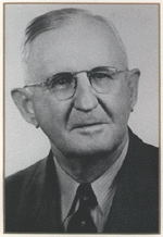
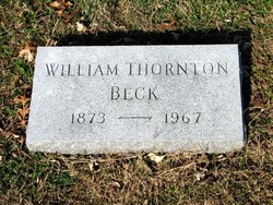

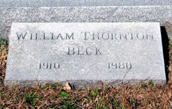
William Thornton Beck
| Birth | : | 14 Feb 1873 Holton, Jackson County, Kansas, USA |
| Death | : | Nov 1967 USA |
| Burial | : | Sullivan Cemetery, Winthrop, Okanogan County, USA |
| Coordinate | : | 48.4742012, -120.1707993 |
| Plot | : | Section A |
| Description | : | member of the Kansas Newspaper Hall of Fame "Will Beck was born in Holton on February 14, 1873. His father M.M. founded the Holton Recorder two years later. Beck went to work as a printer's devil at age 10, and would work on the Recorder in some capacity until his death eight decades later. Beck graduated from Campbell College in Holton and attended the University of Michigan. Active in the state Republican party, he was a delegate to three national conventions. He served as president of the Kansas Editorial Association in 1927, and in 1955 received the William Allen White Foundation Award for... Read More |
frequently asked questions (FAQ):
-
Where is William Thornton Beck's memorial?
William Thornton Beck's memorial is located at: Sullivan Cemetery, Winthrop, Okanogan County, USA.
-
When did William Thornton Beck death?
William Thornton Beck death on Nov 1967 in USA
-
Where are the coordinates of the William Thornton Beck's memorial?
Latitude: 48.4742012
Longitude: -120.1707993
Family Members:
Parent
Spouse
Siblings

Children
Flowers:


Nearby Cemetories:
1. Sullivan Cemetery
Winthrop, Okanogan County, USA
Coordinate: 48.4742012, -120.1707993
2. Old Winthrop Cemetery
Winthrop, Okanogan County, USA
Coordinate: 48.4748000, -120.1864700
3. Beaver Creek Cemetery
Twisp, Okanogan County, USA
Coordinate: 48.3272000, -120.0564000
4. Conconully Cemetery
Conconully, Okanogan County, USA
Coordinate: 48.5441600, -119.7400100
5. Ruby Cemetery
Okanogan County, USA
Coordinate: 48.5085983, -119.7221985
6. Chiliwist Cemetery
Okanogan County, USA
Coordinate: 48.2630997, -119.7363968
7. Malott Community Cemetery
Malott, Okanogan County, USA
Coordinate: 48.2925000, -119.7047300
8. Paradise Hill Cemetery
Brewster, Okanogan County, USA
Coordinate: 48.1848980, -119.8411900
9. Spring Coulee Family Cemetery
Okanogan County, USA
Coordinate: 48.3895950, -119.6289460
10. Methow Cemetery
Methow, Okanogan County, USA
Coordinate: 48.1102982, -120.0124969
11. Pine Creek Cemetery
Tonasket, Okanogan County, USA
Coordinate: 48.6330560, -119.6502780
12. Okanogan City Cemetery
Okanogan, Okanogan County, USA
Coordinate: 48.3546982, -119.6061020
13. Okanogan Valley Memorial Gardens
Omak, Okanogan County, USA
Coordinate: 48.3911018, -119.5691986
14. Omak Memorial Cemetery
Okanogan, Okanogan County, USA
Coordinate: 48.3874000, -119.5565800
15. South Pine Creek Cemetery
Riverside, Okanogan County, USA
Coordinate: 48.5925900, -119.5663400
16. Stoddard Gravesite
Okanogan, Okanogan County, USA
Coordinate: 48.4531140, -119.5411680
17. Elizabeth Osborn Mikel Gravesite
Brewster, Okanogan County, USA
Coordinate: 48.1498900, -119.7514700
18. Riverside Cemetery
Riverside, Okanogan County, USA
Coordinate: 48.4944400, -119.5022200
19. Cameron Lake Pioneer Memorial Cemetery
Malott, Okanogan County, USA
Coordinate: 48.2708330, -119.5700000
20. Locust Grove Cemetery
Brewster, Okanogan County, USA
Coordinate: 48.1114006, -119.7746964
21. Miller Family Cemetery
Okanogan County, USA
Coordinate: 48.0530300, -119.9288000
22. Dick Family Cemetery
Okanogan County, USA
Coordinate: 48.0502700, -119.9241700
23. Pateros Cemetery
Pateros, Okanogan County, USA
Coordinate: 48.0516600, -119.9097300
24. Sand Flats Cemetery
Omak, Okanogan County, USA
Coordinate: 48.4157600, -119.4836600