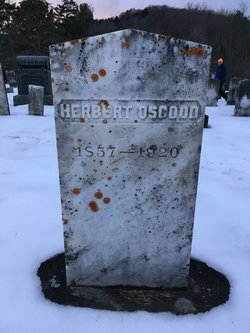
William W. Osgood
| Birth | : | 5 Dec 1843 Randolph, Orange County, Vermont, USA |
| Death | : | 5 Aug 1907 Randolph, Orange County, Vermont, USA |
| Burial | : | Saint Paul Catholic Cemetery, Saint Paul, Grayson County, USA |
| Coordinate | : | 37.5391998, -86.1980972 |
| Plot | : | Section 1 Row 11 Plot #63 |
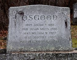
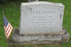
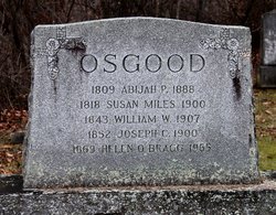
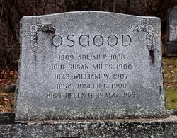
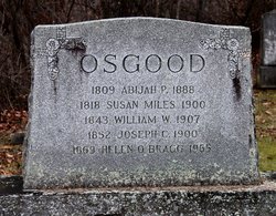
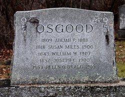
| Inscription | : | 1843 WILLIAM W. 1900 |
| Description | : | Abijah P. Osgood, Susan Miles, William W. Osgood, Joseph L. Osgood, Helen Bragg on the same stone. |
frequently asked questions (FAQ):
-
Where is William W. Osgood's memorial?
William W. Osgood's memorial is located at: Saint Paul Catholic Cemetery, Saint Paul, Grayson County, USA.
-
When did William W. Osgood death?
William W. Osgood death on 5 Aug 1907 in Randolph, Orange County, Vermont, USA
-
Where are the coordinates of the William W. Osgood's memorial?
Latitude: 37.5391998
Longitude: -86.1980972
Family Members:
Parent
Siblings
Flowers:
Nearby Cemetories:
1. Saint Paul Catholic Cemetery
Saint Paul, Grayson County, USA
Coordinate: 37.5391998, -86.1980972
2. Saint Elizabeth Cemetery
Clarkson, Grayson County, USA
Coordinate: 37.5031013, -86.2193985
3. Petty Cemetery
Big Clifty, Grayson County, USA
Coordinate: 37.5503360, -86.1469590
4. Saint Mary Cemetery
Big Clifty, Grayson County, USA
Coordinate: 37.5493460, -86.1456600
5. Cedar Hill Cemetery
Big Clifty, Grayson County, USA
Coordinate: 37.5497017, -86.1453018
6. Petty Cemetery
Grayson County, USA
Coordinate: 37.5505981, -86.1444016
7. Clarkson Cemetery
Clarkson, Grayson County, USA
Coordinate: 37.4967030, -86.2146150
8. Mulberry Flats Cemetery
Leitchfield, Grayson County, USA
Coordinate: 37.5164870, -86.2508530
9. Moore Cemetery #2
Eastview, Hardin County, USA
Coordinate: 37.5881160, -86.1810570
10. Moore Cemetery #1
Hardin County, USA
Coordinate: 37.5881700, -86.1810200
11. Hazelwood Cemetery
Leitchfield, Grayson County, USA
Coordinate: 37.5587000, -86.2616000
12. Hazelwood Cemetery
Grayson County, USA
Coordinate: 37.5586014, -86.2617035
13. Beaver Dam Cemetery
Leitchfield, Grayson County, USA
Coordinate: 37.4991740, -86.2485450
14. Mount Hebron Cemetery
Grayson County, USA
Coordinate: 37.5813720, -86.2506300
15. Saint Francis Cemetery
Leitchfield, Grayson County, USA
Coordinate: 37.5815360, -86.2520010
16. Antioch Christian Church Cemetery
Big Clifty, Grayson County, USA
Coordinate: 37.5240780, -86.1109310
17. Pleasant Grove Methodist Church Cemetery
Hardin County, USA
Coordinate: 37.6116982, -86.2117004
18. Akers Family Cemetery
Summit, Hardin County, USA
Coordinate: 37.5673190, -86.1124840
19. New Hope Church Of Christ Cemetery
Big Clifty, Grayson County, USA
Coordinate: 37.5222300, -86.1076070
20. Holly Missionary Baptist Church Cemetery
Eveleigh, Grayson County, USA
Coordinate: 37.5534240, -86.2895390
21. Kerr Cemetery
Leitchfield, Grayson County, USA
Coordinate: 37.5144005, -86.2869034
22. John Griffin Cemetery
Grayson County, USA
Coordinate: 37.5068750, -86.1104540
23. Mount Vernon Church Cemetery
Leitchfield, Grayson County, USA
Coordinate: 37.5133900, -86.2901800
24. Dellview Cemetery
Hardin County, USA
Coordinate: 37.5793991, -86.1141968

