
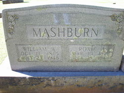
William Wesley “Bud” Mashburn
| Birth | : | 13 Oct 1865 North Carolina, USA |
| Death | : | 23 Jul 1948 Macon County, North Carolina, USA |
| Burial | : | Pleasant Hill Baptist Church Cemetery, Springfield, Orangeburg County, USA |
| Coordinate | : | 33.5308060, -81.2372610 |
| Description | : | father: William "Billy" F. Mashburn ▬▬▬▬▬▬▬▬▬▬ஜ۩۞۩ஜ▬▬▬▬▬▬▬▬▬▬ RITES HELD FOR W. W. MASHBURN Well Known Farmer, Livestock Dealer Dies At Age Of 82 Funeral services for W. W. (Bud) Mashburn, well known Macon County farmer and livestock dealer, were held at the Bethel Methodist church at 11 a. m. Sunday, July 25, with the Rev. L. C. Stevens, pastor of the Methodist Macon circuit, assisted by the Rev. W. L. Sorrells, officiating. Mr. Mashburn died at his home, Franklin, Route 1, at 6:30 a. m. July 23 following an illness of a year. A native of this county, he was the son of William and... Read More |
frequently asked questions (FAQ):
-
Where is William Wesley “Bud” Mashburn's memorial?
William Wesley “Bud” Mashburn's memorial is located at: Pleasant Hill Baptist Church Cemetery, Springfield, Orangeburg County, USA.
-
When did William Wesley “Bud” Mashburn death?
William Wesley “Bud” Mashburn death on 23 Jul 1948 in Macon County, North Carolina, USA
-
Where are the coordinates of the William Wesley “Bud” Mashburn's memorial?
Latitude: 33.5308060
Longitude: -81.2372610
Family Members:
Parent
Spouse

Siblings
Children


Flowers:


Nearby Cemetories:
1. Pleasant Hill Baptist Church Cemetery
Springfield, Orangeburg County, USA
Coordinate: 33.5308060, -81.2372610
2. Edward Bolin Family Cemetery
Springfield, Orangeburg County, USA
Coordinate: 33.5273000, -81.2275030
3. Oakey Spring Baptist Church Cemetery
Springfield, Orangeburg County, USA
Coordinate: 33.5375190, -81.2700730
4. Gin Branch Cemetery
Orangeburg County, USA
Coordinate: 33.5582085, -81.2614899
5. Bailey Cemetery
Neeses, Orangeburg County, USA
Coordinate: 33.5535170, -81.2019500
6. Gleaton-Fogle-Corbett Cemetery
Neeses, Orangeburg County, USA
Coordinate: 33.5444330, -81.1955790
7. Rocky Swamp Southern Methodist Church Cemetery
Neeses, Orangeburg County, USA
Coordinate: 33.5093200, -81.1953380
8. Gibson Cemetery
Springfield, Orangeburg County, USA
Coordinate: 33.5699480, -81.2198720
9. Rocky Swamp Methodist Church Cemetery
Neeses, Orangeburg County, USA
Coordinate: 33.5097600, -81.1908120
10. Morgan Family Cemetery
Springfield, Orangeburg County, USA
Coordinate: 33.4862595, -81.2287064
11. Davis Family Cemetery
Neeses, Orangeburg County, USA
Coordinate: 33.5588220, -81.1930310
12. Williams Family Cemetery
Springfield, Orangeburg County, USA
Coordinate: 33.4901730, -81.2649830
13. Brodie Family Cemetery
Springfield, Orangeburg County, USA
Coordinate: 33.4968500, -81.2758630
14. Gospel Temple Baptist Church Cemetery
Neeses, Orangeburg County, USA
Coordinate: 33.5285610, -81.1809660
15. Springfield Methodist Church Cemetery
Orangeburg County, USA
Coordinate: 33.4970000, -81.2771000
16. Springfield Cemetery
Springfield, Orangeburg County, USA
Coordinate: 33.4890404, -81.2650986
17. Miller Family Cemetery
Jamison, Orangeburg County, USA
Coordinate: 33.5042750, -81.2885380
18. Odom Family Cemetery
Springfield, Orangeburg County, USA
Coordinate: 33.4837150, -81.2636380
19. Hopewell Southern Methodist Church Cemetery
Neeses, Orangeburg County, USA
Coordinate: 33.5826760, -81.2242090
20. Samaria Baptist Church Cemetery
Springfield, Orangeburg County, USA
Coordinate: 33.5097510, -81.2994180
21. Epting Family Cemetery
Springfield, Orangeburg County, USA
Coordinate: 33.5224950, -81.3051030
22. Axson Family Cemetery
Neeses, Orangeburg County, USA
Coordinate: 33.5812300, -81.2046300
23. Gleaton-Fogle-Corbett Family Cemetery
Neeses, Orangeburg County, USA
Coordinate: 33.5605600, -81.1784560
24. Fanning Family Cemetery
Springfield, Orangeburg County, USA
Coordinate: 33.5362790, -81.3058450