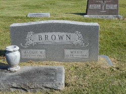
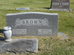
Willie Brown
| Birth | : | 29 Jan 1877 Ray County, Missouri, USA |
| Death | : | 7 Nov 1966 Excelsior Springs, Clay County, Missouri, USA |
| Burial | : | Center Cemetery, Danville, Rockingham County, USA |
| Coordinate | : | 42.9303017, -71.1235962 |
| Plot | : | Section 3 |
| Description | : | MO Death Cert # 66-0044704 Father = James Brown Mother = Mary Kathryn Artman Widow = Maggie Mae Brown Informant = George A. Brown Occupation = Farmer COD = Arteriosclerosis |
frequently asked questions (FAQ):
-
Where is Willie Brown's memorial?
Willie Brown's memorial is located at: Center Cemetery, Danville, Rockingham County, USA.
-
When did Willie Brown death?
Willie Brown death on 7 Nov 1966 in Excelsior Springs, Clay County, Missouri, USA
-
Where are the coordinates of the Willie Brown's memorial?
Latitude: 42.9303017
Longitude: -71.1235962
Family Members:
Spouse
Children
Flowers:
Nearby Cemetories:
1. Center Cemetery
Danville, Rockingham County, USA
Coordinate: 42.9303017, -71.1235962
2. North Danville Cemetery
Danville, Rockingham County, USA
Coordinate: 42.9371920, -71.1184170
3. Old Meeting House Cemetery
Danville, Rockingham County, USA
Coordinate: 42.9371920, -71.1184170
4. Meetinghouse Cemetery
Danville, Rockingham County, USA
Coordinate: 42.9370790, -71.1179230
5. Ye Old Cemetery
Danville, Rockingham County, USA
Coordinate: 42.9397011, -71.1205978
6. Dimond Cemetery
Danville, Rockingham County, USA
Coordinate: 42.9146590, -71.1277470
7. Collins Cemetery
South Danville, Rockingham County, USA
Coordinate: 42.9069500, -71.1222600
8. Collins Cemetery
Danville, Rockingham County, USA
Coordinate: 42.9066577, -71.1219277
9. Blake Road Graveyard
Rockingham County, USA
Coordinate: 42.9067700, -71.1159400
10. Bagley Family Cemetery
Danville, Rockingham County, USA
Coordinate: 42.9038890, -71.1080560
11. Eaton Cemetery
South Danville, Rockingham County, USA
Coordinate: 42.8991700, -71.1218500
12. Soldiers Cemetery
Rockingham County, USA
Coordinate: 42.8936005, -71.1108017
13. West Brentwood Cemetery
Brentwood, Rockingham County, USA
Coordinate: 42.9628370, -71.0942900
14. Hoyt-Currier Cemetery
Fremont, Rockingham County, USA
Coordinate: 42.9677780, -71.1388890
15. Pine Knoll Cemetery
East Hampstead, Rockingham County, USA
Coordinate: 42.8922130, -71.1369390
16. Isaac Brown Cemetery
Fremont, Rockingham County, USA
Coordinate: 42.9681000, -71.0952000
17. Ladd-Fellows Cemetery
Brentwood, Rockingham County, USA
Coordinate: 42.9636002, -71.0852966
18. Brentwood Cemetery
Brentwood, Rockingham County, USA
Coordinate: 42.9637000, -71.0847800
19. Pine Grove Cemetery
Kingston, Rockingham County, USA
Coordinate: 42.9121300, -71.0682300
20. Center Cemetery
Sandown, Rockingham County, USA
Coordinate: 42.9256420, -71.1861710
21. Ray Cemetery
East Hampstead, Rockingham County, USA
Coordinate: 42.8836120, -71.1330550
22. Devenell-Tasker Cemetery
Strafford, Strafford County, USA
Coordinate: 42.8827780, -71.1330560
23. Greenwood Cemetery
Kingston, Rockingham County, USA
Coordinate: 42.9422569, -71.0596161
24. Plains Cemetery
Kingston, Rockingham County, USA
Coordinate: 42.9341340, -71.0522750


