


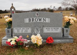
Willie Jim “Tom” Brown
| Birth | : | 18 Dec 1921 Moss, Clay County, Tennessee, USA |
| Death | : | 24 Dec 2010 Celina, Clay County, Tennessee, USA |
| Burial | : | Dawson Memorial Park, Glendive, Dawson County, USA |
| Coordinate | : | 47.0889015, -104.7746964 |
| Description | : | Willie Jim "Tom" Brown, 89 Moss, Tennessee Tom Brown passed away Friday, December 24, 2010 at the Cumberland River Hospital in Celina, Tennessee. Willie Jim Brown was born December 18, 1921 in Moss, Tennessee to the late Luke and Cora (Craighead) Brown. Willie Brown was a farmer and affiliated with the Church of Christ. His family includes spouse, Mona Brown of Moss; sons, Buster Brown & Frances of Moss & Clyde Brown & wife, Peggy of Moss; daughters, Diana Webb & husband, Ronnie of Celina, Joy Rhoton of Moss and Wendy Spears & husband, David of Moss; brothers, Aaron Brown of Moss and... Read More |
frequently asked questions (FAQ):
-
Where is Willie Jim “Tom” Brown's memorial?
Willie Jim “Tom” Brown's memorial is located at: Dawson Memorial Park, Glendive, Dawson County, USA.
-
When did Willie Jim “Tom” Brown death?
Willie Jim “Tom” Brown death on 24 Dec 2010 in Celina, Clay County, Tennessee, USA
-
Where are the coordinates of the Willie Jim “Tom” Brown's memorial?
Latitude: 47.0889015
Longitude: -104.7746964
Family Members:
Parent

Spouse

Siblings

Flowers:


Nearby Cemetories:
1. Dawson Memorial Park
Glendive, Dawson County, USA
Coordinate: 47.0889015, -104.7746964
2. Dawson County Cemetery
Glendive, Dawson County, USA
Coordinate: 47.1105995, -104.6971970
3. Pleasant View Cemetery
Pleasant View, Dawson County, USA
Coordinate: 47.0362630, -104.9326090
4. Gluecksthal Lutheran Cemetery
Marsh, Dawson County, USA
Coordinate: 46.8848000, -104.9326000
5. Marsh Cemetery
Dawson County, USA
Coordinate: 46.8828011, -104.9306030
6. Grand View Cemetery
Dawson County, USA
Coordinate: 47.2971992, -104.5378036
7. Red Top Mennonite Cemetery
Red Top, Dawson County, USA
Coordinate: 47.4160995, -104.8106003
8. Lutheran Cemetery
Fallon, Prairie County, USA
Coordinate: 46.8320800, -105.1120100
9. West Church Cemetery
Dawson County, USA
Coordinate: 47.3266983, -105.1502991
10. Immanuel Evangelical Lutheran Cemetery
Bloomfield, Dawson County, USA
Coordinate: 47.4415000, -104.6735000
11. Union Cemetery
Dawson County, USA
Coordinate: 47.1822014, -105.2882996
12. Fallon Cemetery
Prairie County, USA
Coordinate: 46.8168983, -105.1327972
13. Little Flat Community Cemetery
Fallon, Prairie County, USA
Coordinate: 46.7659300, -105.0487600
14. Wibaux County Cemetery
Wibaux, Wibaux County, USA
Coordinate: 46.9846992, -104.1999969
15. Pierre Wibaux Memorial Site
Wibaux, Wibaux County, USA
Coordinate: 46.9884800, -104.1981600
16. Mildred Cemetery
Mildred, Prairie County, USA
Coordinate: 46.6850204, -104.9543457
17. Been Cemetery
Wibaux, Wibaux County, USA
Coordinate: 47.2094002, -104.1763992
18. Bethlehem Mennonite Cemetery
Bloomfield, Dawson County, USA
Coordinate: 47.5280000, -104.8747000
19. Riverview Cemetery
Savage, Richland County, USA
Coordinate: 47.4453011, -104.3443985
20. Blue Mountain Cemetery
Wibaux County, USA
Coordinate: 47.1650009, -104.1031036
21. Kiempel Cemetery
Dawson County, USA
Coordinate: 47.5780983, -104.7574997
22. Prairie County Cemetery
Terry, Prairie County, USA
Coordinate: 46.7881012, -105.3443985
23. Saint Philips Cemetery
Wibaux County, USA
Coordinate: 46.8208008, -104.1444016
24. Arnett Cemetery
Dawson County, USA
Coordinate: 47.4542007, -105.3638992