

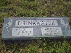
Wilma Evelyn Spiller Drinkwater
| Birth | : | 18 Jun 1916 Clements, Chase County, Kansas, USA |
| Death | : | 19 Aug 2002 Sedalia, Pettis County, Missouri, USA |
| Burial | : | Mount Carmel United Methodist Church Cemetery, Big Pool, Washington County, USA |
| Coordinate | : | 39.6171989, -77.9978027 |
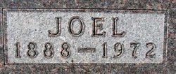
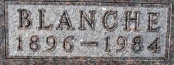
| Description | : | Drinkwater, Wilma Evelyn Wilma Evelyn Drinkwater, 86, of Sedalia, Mo., died Aug. 19, 2002, at her home. She was born June 18, 1916, at Clements, daughter of Joel and Blanche Dickson Spiller. On Jan. 17, 1936, in Junction City, she married Orlo Henry Drinkwater, who died Dec. 5, 1987. Mrs. Drinkwater grew up on Chase County. She moved to Frankfort in 1933, and graduated from Frankfort High School. She and her husband owned and operated Drinkwater's Hy-Klas Grocery Store in Centralia for 26 years before retiring and moving to Sedalia in 1983. She was a member of the Immanuel United Church... Read More |
frequently asked questions (FAQ):
-
Where is Wilma Evelyn Spiller Drinkwater's memorial?
Wilma Evelyn Spiller Drinkwater's memorial is located at: Mount Carmel United Methodist Church Cemetery, Big Pool, Washington County, USA.
-
When did Wilma Evelyn Spiller Drinkwater death?
Wilma Evelyn Spiller Drinkwater death on 19 Aug 2002 in Sedalia, Pettis County, Missouri, USA
-
Where are the coordinates of the Wilma Evelyn Spiller Drinkwater's memorial?
Latitude: 39.6171989
Longitude: -77.9978027
Family Members:
Parent
Spouse
Siblings
Children
Flowers:


Nearby Cemetories:
1. Mount Carmel United Methodist Church Cemetery
Big Pool, Washington County, USA
Coordinate: 39.6171989, -77.9978027
2. Green Spring Cemetery
Clear Spring, Washington County, USA
Coordinate: 39.6253014, -77.9669037
3. Allensville Cemetery
Hedgesville, Berkeley County, USA
Coordinate: 39.5792999, -77.9886017
4. Little Georgetown Cemetery
Little Georgetown, Berkeley County, USA
Coordinate: 39.5838300, -77.9563100
5. Johnsontown Church of the Brethren Cemetery
Hedgesville, Berkeley County, USA
Coordinate: 39.5794411, -78.0363922
6. Boyd Farm Graveyard
Clear Spring, Washington County, USA
Coordinate: 39.6475350, -77.9463240
7. Old Johnsontown Brethren Cemetery
Johnsontown, Berkeley County, USA
Coordinate: 39.5776900, -78.0376200
8. Park Head Cemetery
Big Pool, Washington County, USA
Coordinate: 39.6547000, -78.0478000
9. Snyder Family Cemetery
Pecktonville, Washington County, USA
Coordinate: 39.6547750, -78.0513210
10. Snyders Bible Chapel Cemetery
Holton, Morgan County, USA
Coordinate: 39.6046982, -78.0736008
11. Forsyth Family Plot
Clear Spring, Washington County, USA
Coordinate: 39.6768390, -77.9881670
12. Little Metropolitan AME Cemetery
Clear Spring, Washington County, USA
Coordinate: 39.6520900, -77.9311700
13. Saint Michael's Catholic Cemetery
Clear Spring, Washington County, USA
Coordinate: 39.6544000, -77.9315000
14. Saint Peters Lutheran Church Cemetery
Clear Spring, Washington County, USA
Coordinate: 39.6543999, -77.9310989
15. Hedgesville Cemetery
Hedgesville, Berkeley County, USA
Coordinate: 39.5536003, -77.9927979
16. Hedgesville Assembly of God Cemetery
Hedgesville, Berkeley County, USA
Coordinate: 39.5538600, -78.0256300
17. Clear Spring Methodist Episcopal Cemetery
Clear Spring, Washington County, USA
Coordinate: 39.6575790, -77.9284290
18. Falling Waters Presbyterian Cemetery
Spring Mills, Berkeley County, USA
Coordinate: 39.5580254, -77.9534454
19. Clear Spring Mennonite Church Cemetery
Clear Spring, Washington County, USA
Coordinate: 39.6460800, -77.9138500
20. Pleasant Hill Cemetery
Cherry Run, Morgan County, USA
Coordinate: 39.6535988, -78.0781021
21. Bethel Cemetery
Sleepy Creek, Morgan County, USA
Coordinate: 39.6567001, -78.0785980
22. Trinity Christian Church Cemetery
Clear Spring, Washington County, USA
Coordinate: 39.6604540, -77.9201530
23. Rose Hill Cemetery
Clear Spring, Washington County, USA
Coordinate: 39.6580400, -77.9177500
24. Schrivers Cemetery
Cherry Run, Morgan County, USA
Coordinate: 39.6385994, -78.0899963