
| Birth | : | 13 Jun 1916 Fontanelle, Adair County, Iowa, USA |
| Death | : | 23 Feb 2001 Corning, Adams County, Iowa, USA |
| Burial | : | Grafton Center Cemetery, Grafton Center, Grafton County, USA |
| Coordinate | : | 43.5764700, -71.9746500 |
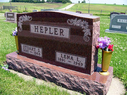
| Description | : | Wilma Ford was born June 13, 1916 in Jackson Township, Adair County, Iowa to Stuart and Lena (Rechtenbach) Hepler. She died February 23, 2001 at Alegent Health Mercy Hospital in Corning, Iowa. She attended rural schools through the eighth grade. On February 26, 1936 she married Otis Ford at the Methodist Parsonage in Greenfield. They farmed south of Bridgewater and later moved to the Ford family farm in Washington Township where they lived until moving to Bridgewater in 1962. She was active in many church, community and social groups, including the Eastern Star. Survivors include husband Otis Ford; sons, S. Marvin (Darlene)... Read More |
frequently asked questions (FAQ):
-
Where is Wilma Marie Hepler Ford's memorial?
Wilma Marie Hepler Ford's memorial is located at: Grafton Center Cemetery, Grafton Center, Grafton County, USA.
-
When did Wilma Marie Hepler Ford death?
Wilma Marie Hepler Ford death on 23 Feb 2001 in Corning, Adams County, Iowa, USA
-
Where are the coordinates of the Wilma Marie Hepler Ford's memorial?
Latitude: 43.5764700
Longitude: -71.9746500
Family Members:
Parent

Spouse

Siblings
Children
Flowers:


Nearby Cemetories:
1. Grafton Center Cemetery
Grafton Center, Grafton County, USA
Coordinate: 43.5764700, -71.9746500
2. Pine Grove Cemetery
Grafton, Grafton County, USA
Coordinate: 43.5665300, -71.9554000
3. Razor Hill Cemetery
Grafton, Grafton County, USA
Coordinate: 43.5872300, -71.9532900
4. East Grafton Cemetery
East Grafton, Grafton County, USA
Coordinate: 43.5682800, -71.9296600
5. Barney Plot
Grafton, Grafton County, USA
Coordinate: 43.5597220, -71.9336110
6. Prescott Hill Cemetery
Grafton, Grafton County, USA
Coordinate: 43.5351856, -71.9747934
7. Huntley Cemetery
Grafton County, USA
Coordinate: 43.5697220, -72.0488890
8. Hardy Hill Cemetery
Grafton, Grafton County, USA
Coordinate: 43.5504600, -72.0465200
9. Ford Cemetery
Grafton, Grafton County, USA
Coordinate: 43.5524670, -71.8986510
10. Morse Cemetery
Enfield, Grafton County, USA
Coordinate: 43.6060400, -72.0539100
11. Litchfield Cemetery
Danbury, Merrimack County, USA
Coordinate: 43.5423900, -71.8851600
12. Cobble Hill Cemetery
Canaan, Grafton County, USA
Coordinate: 43.6327780, -72.0416670
13. Choate Cemetery
Enfield Center, Grafton County, USA
Coordinate: 43.5665700, -72.0763900
14. North Road Cemetery
Wilmot, Merrimack County, USA
Coordinate: 43.5104870, -71.9268630
15. French Cemetery
Orange, Grafton County, USA
Coordinate: 43.6544200, -71.9685600
16. Butman Cemetery
Enfield, Grafton County, USA
Coordinate: 43.5952400, -72.0795610
17. Orange Common Cemetery
Orange, Grafton County, USA
Coordinate: 43.6535988, -71.9543991
18. Fowler Cemetery
Springfield, Sullivan County, USA
Coordinate: 43.4975000, -71.9652780
19. Church Cemetery
Orange, Grafton County, USA
Coordinate: 43.6555100, -71.9659600
20. Adams Cemetery
Enfield, Grafton County, USA
Coordinate: 43.5532500, -72.0833200
21. George Hill Cemetery
Enfield Center, Grafton County, USA
Coordinate: 43.5801400, -72.0906600
22. Baptist Cemetery
Danbury, Merrimack County, USA
Coordinate: 43.5336100, -71.8711100
23. Wells Cemetery
Canaan, Grafton County, USA
Coordinate: 43.6563200, -72.0253800
24. Tewksbury Cemetery
Wilmot, Merrimack County, USA
Coordinate: 43.4917669, -71.9407331