
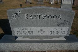

Wylie Earl “Sonny” Eastwood
| Birth | : | 18 Apr 1933 Stapleton, Logan County, Nebraska, USA |
| Death | : | 14 Dec 1998 Holdrege, Phelps County, Nebraska, USA |
| Burial | : | Hope Lutheran Cemetery, Smithfield, Gosper County, USA |
| Coordinate | : | 40.5667500, -99.6800000 |
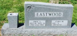
| Description | : | Wylie was a son of Paul Irving Eastwood (1912-1968) & Cuba Miller Richards (1917-2011). Wylie first married Mildred Joan Pearson (1934) on October 31, 1952 in Arnold, Custer Co., Nebraska. They had six identified children. Marriage ended in divorce. Wylie then married Sandra Lee Scheel (1941-2004) on December 17, 1989 in Las Vegas, Clark Co., Indiana. |
frequently asked questions (FAQ):
-
Where is Wylie Earl “Sonny” Eastwood's memorial?
Wylie Earl “Sonny” Eastwood's memorial is located at: Hope Lutheran Cemetery, Smithfield, Gosper County, USA.
-
When did Wylie Earl “Sonny” Eastwood death?
Wylie Earl “Sonny” Eastwood death on 14 Dec 1998 in Holdrege, Phelps County, Nebraska, USA
-
Where are the coordinates of the Wylie Earl “Sonny” Eastwood's memorial?
Latitude: 40.5667500
Longitude: -99.6800000
Family Members:
Parent

Spouse
Flowers:


Nearby Cemetories:
1. Hope Lutheran Cemetery
Smithfield, Gosper County, USA
Coordinate: 40.5667500, -99.6800000
2. Keely Cemetery
Smithfield, Gosper County, USA
Coordinate: 40.5727500, -99.6563500
3. Immanuel Cemetery
Bertrand, Phelps County, USA
Coordinate: 40.5682983, -99.6283035
4. Highland Cemetery
Bertrand, Phelps County, USA
Coordinate: 40.5194016, -99.6430969
5. Yoder Cemetery
Smithfield, Gosper County, USA
Coordinate: 40.4957000, -99.6845500
6. Sandstrom Cemetery
Phelps County, USA
Coordinate: 40.5983009, -99.5661011
7. Adullam Cemetery
Bertrand, Phelps County, USA
Coordinate: 40.6265000, -99.5856000
8. Robb Cemetery
Smithfield, Gosper County, USA
Coordinate: 40.6710691, -99.6996001
9. Quakerville Cemetery
Gosper County, USA
Coordinate: 40.6189003, -99.8097000
10. Fairfield Cemetery
Gosper County, USA
Coordinate: 40.4672012, -99.7549973
11. Plum Creek Massacre Cemetery
Phelps County, USA
Coordinate: 40.6726840, -99.6058220
12. Elwood Cemetery
Elwood, Gosper County, USA
Coordinate: 40.5999300, -99.8397300
13. Loomis Cemetery
Loomis, Phelps County, USA
Coordinate: 40.4801860, -99.5128300
14. Platte Valley Cemetery
Phelps County, USA
Coordinate: 40.6425018, -99.5028000
15. Shaw Cemetery
Phelps County, USA
Coordinate: 40.4303017, -99.5781021
16. Zion Cemetery
Gosper County, USA
Coordinate: 40.4085999, -99.7005997
17. Homerville Cemetery
Gosper County, USA
Coordinate: 40.4668999, -99.8593979
18. Williamsburg Cemetery
Phelps County, USA
Coordinate: 40.6490290, -99.4543150
19. McGuire Cemetery
Gosper County, USA
Coordinate: 40.4380989, -99.8664017
20. Moses Hill Cemetery
Loomis, Phelps County, USA
Coordinate: 40.5104490, -99.4388600
21. Evergreen Cemetery
Lexington, Dawson County, USA
Coordinate: 40.7639008, -99.6791992
22. Overton Cemetery
Overton, Dawson County, USA
Coordinate: 40.7317009, -99.5222015
23. Immanuel Lutheran Cemetery
Elwood, Gosper County, USA
Coordinate: 40.4206500, -99.8672000
24. Pleasant Grove Cemetery
Gosper County, USA
Coordinate: 40.4664001, -99.9250031