
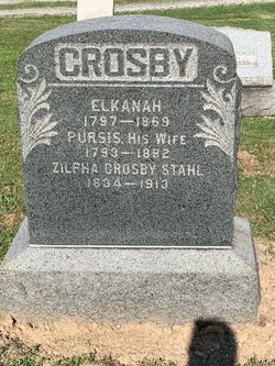

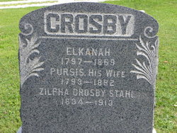
Zilpha Ann Crosby Stahl
| Birth | : | 5 Jul 1834 Cherry Valley, Ashtabula County, Ohio, USA |
| Death | : | 29 Jan 1913 Jefferson, Ashtabula County, Ohio, USA |
| Burial | : | Nara Visa Cemetery, Nara Visa, Quay County, USA |
| Coordinate | : | 35.6064900, -103.1161400 |
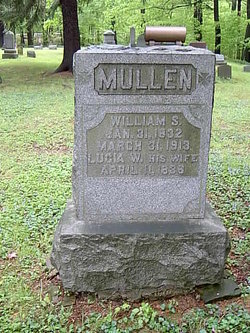
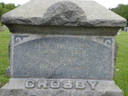
| Description | : | Married to Ebenezer Jackson on 10 Jan 1870 in Jefferson OH, then to William Selby Mullen on 17 Apr 1904 in Ashtabula Co, and finally to unknown Stahl. Groom's Name: Ebenezer Jackson Groom's Birth Date: Groom's Birthplace: Groom's Age: Bride's Name: Zilpha Ann Crosby Bride's Birth Date: Bride's Birthplace: Bride's Age: Marriage Date: 10 Jan 1870 Marriage Place: Jefferson, Ashtabula, Ohio Groom's Father's Name: Groom's Mother's Name: Bride's Father's Name: Bride's Mother's Name: Groom's Race: Groom's Marital Status: Groom's Previous Wife's Name: Bride's Race: Bride's Marital Status: Bride's Previous Husband's Name: Indexing Project (Batch) Number: M00008-7 System Origin: Ohio-VR Source Film Number: 890272 Reference Number: 2:3KBMLPC Collection: Ohio Marriages,... Read More |
frequently asked questions (FAQ):
-
Where is Zilpha Ann Crosby Stahl's memorial?
Zilpha Ann Crosby Stahl's memorial is located at: Nara Visa Cemetery, Nara Visa, Quay County, USA.
-
When did Zilpha Ann Crosby Stahl death?
Zilpha Ann Crosby Stahl death on 29 Jan 1913 in Jefferson, Ashtabula County, Ohio, USA
-
Where are the coordinates of the Zilpha Ann Crosby Stahl's memorial?
Latitude: 35.6064900
Longitude: -103.1161400
Family Members:
Parent

Spouse
Siblings
Flowers:


Nearby Cemetories:
1. Nara Visa Cemetery
Nara Visa, Quay County, USA
Coordinate: 35.6064900, -103.1161400
2. Independent Order of Odd Fellows Cemetery
Nara Visa, Quay County, USA
Coordinate: 35.6158400, -103.1076100
3. Obar Cemetery
Obar, Quay County, USA
Coordinate: 35.5200005, -103.2027969
4. Obar Cemetery
Amistad, Union County, USA
Coordinate: 35.5200900, -103.2032700
5. Rowe Cemetery
Quay County, USA
Coordinate: 35.6528850, -103.3075550
6. Cherokee Valley Cemetery
Quay County, USA
Coordinate: 35.6530991, -103.3285980
7. Centerville Cemetery
Centerville, Union County, USA
Coordinate: 35.7980000, -103.0986000
8. Fairview Cemetery
Amistad, Union County, USA
Coordinate: 35.8233810, -103.1616210
9. Fairmount Cemetery
Union County, USA
Coordinate: 35.8236008, -103.1607971
10. Amistad Cemetery
Amistad, Union County, USA
Coordinate: 35.9077988, -103.1769028
11. Logan Cemetery
Logan, Quay County, USA
Coordinate: 35.3774986, -103.3858032
12. Rana Cemetery
Quay County, USA
Coordinate: 35.2999600, -103.2768900
13. Rosebud Cemetery
Harding County, USA
Coordinate: 35.8319016, -103.4638977
14. Vigil Cemetery
Harding County, USA
Coordinate: 35.4143982, -103.5192032
15. Hayden Cemetery
Hayden, Union County, USA
Coordinate: 35.9658000, -103.2708000
16. Holy Trinity Catholic Cemetery
Hayden, Union County, USA
Coordinate: 35.9694000, -103.2695000
17. Anniston Cemetery
Quay County, USA
Coordinate: 35.2571983, -103.3218994
18. Genova Cemetery
Harding County, USA
Coordinate: 35.5395900, -103.5927900
19. Alamosa Cemetery
Harding County, USA
Coordinate: 35.4502983, -103.5706024
20. Cejita Cemetery
Harding County, USA
Coordinate: 35.8274994, -103.5864029
21. Maytum Cemetery
Harding County, USA
Coordinate: 35.9439011, -103.4950027
22. Endee Cemetery
Quay County, USA
Coordinate: 35.1453018, -103.1247025
23. Pedernal Cemetery
Hayden, Union County, USA
Coordinate: 36.0174800, -103.4244100
24. Pedernal Cemetery
Harding County, USA
Coordinate: 36.0175018, -103.4246979