
| Memorials | : | 0 |
| Location | : | Abtshagen, Landkreis Vorpommern-Rügen, Germany |
| Coordinate | : | 54.1905300, 13.0200500 |
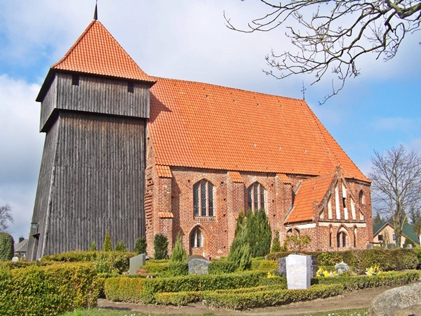
| Description | : | The Abtshagen cemetery is located on the grounds of the Abtshagen parish church. The village of Abtshagen is in the German federal state of Mecklenburg-Vorpommern. It is on Highway 194. Abtshagen is 4.5 km south of the town of Steinhagen and about 7.5 km north of the town of Grimmen. Stralsund, to the north, is probably the closest large city. The church structure dates back to 1380, the wooden tower was built in 1667. It's locally known as "Heilgeistkirche" (Holy Ghost Church). Thanks to "Frank", a findagrave.com contributor, who generously provided the photograph and an historical description. findagrave.com's database for German... Read More |
frequently asked questions (FAQ):
-
Where is Abtshagen?
Abtshagen is located at Wittenhagen Township Abtshagen, Landkreis Vorpommern-Rügen ,Mecklenburg-Vorpommern , 18510Germany.
-
Abtshagen cemetery's updated grave count on graveviews.com?
0 memorials
-
Where are the coordinates of the Abtshagen?
Latitude: 54.1905300
Longitude: 13.0200500
Nearby Cemetories:
1. Dorfkirche Voigdehagen
Voigdehagen, Landkreis Vorpommern-Rügen, Germany
Coordinate: 54.2699720, 13.0933610
2. Jüdischer Friedhof Stralsund
Stralsund, Landkreis Vorpommern-Rügen, Germany
Coordinate: 54.2909470, 13.0935840
3. Frankenfriedhof
Stralsund, Landkreis Vorpommern-Rügen, Germany
Coordinate: 54.3027798, 13.0942589
4. Sankt-Marien-Kirchhof Stralsund
Stralsund, Landkreis Vorpommern-Rügen, Germany
Coordinate: 54.3098620, 13.0870560
5. Sankt-Marien-Kirche Stralsund
Stralsund, Landkreis Vorpommern-Rügen, Germany
Coordinate: 54.3099330, 13.0879310
6. Sowjetischer Ehrenfriedhof Stralsund
Stralsund, Landkreis Vorpommern-Rügen, Germany
Coordinate: 54.3105020, 13.0881180
7. Sankt-Jacobi-Kirchhof Stralsund
Stralsund, Landkreis Vorpommern-Rügen, Germany
Coordinate: 54.3130810, 13.0919590
8. Saint Jurgen Friedhof
Stralsund, Landkreis Vorpommern-Rügen, Germany
Coordinate: 54.3239670, 13.0759190
9. Zentralfriedhof Stralsund
Stralsund, Landkreis Vorpommern-Rügen, Germany
Coordinate: 54.3312820, 13.0632160
10. Friedhof Rügen-Gustow
Gustow, Landkreis Vorpommern-Rügen, Germany
Coordinate: 54.3018300, 13.2137000
11. Dorfkirche Starkow St. Jürgen
Starkow, Landkreis Vorpommern-Rügen, Germany
Coordinate: 54.2752339, 12.7518441
12. Alter Friedhof Tribsees
Tribsees, Landkreis Vorpommern-Rügen, Germany
Coordinate: 54.0913182, 12.7637109
13. Friedhof Rügen-Poseritz
Poseritz, Landkreis Vorpommern-Rügen, Germany
Coordinate: 54.2981300, 13.2768800
14. St.-Johannes-Kirche zu Rambin
Rambin, Landkreis Vorpommern-Rügen, Germany
Coordinate: 54.3550560, 13.2048370
15. Friedhof Rügen-Rambin
Rambin, Landkreis Vorpommern-Rügen, Germany
Coordinate: 54.3550600, 13.2048300
16. Friedhof Rügen-Swantow
Landkreis Vorpommern-Rügen, Germany
Coordinate: 54.2889500, 13.3253400
17. Friedhof Langsdorf
Langsdorf, Landkreis Vorpommern-Rügen, Germany
Coordinate: 54.0776218, 12.7193233
18. St. Marienkirche Kenz
Stralsund, Landkreis Vorpommern-Rügen, Germany
Coordinate: 54.3263440, 12.7359760
19. Alter Friedhof
Neuenkirchen, Landkreis Vorpommern-Greifswald, Germany
Coordinate: 54.1186957, 13.3758868
20. Saint Joseph Catholic Church (Katholische Kirche)
Greifswald, Landkreis Vorpommern-Greifswald, Germany
Coordinate: 54.0929776, 13.3754894
21. Dom St Nikolai
Greifswald, Landkreis Vorpommern-Greifswald, Germany
Coordinate: 54.0954365, 13.3774535
22. Friedhof Rügen-Garz
Landkreis Vorpommern-Rügen, Germany
Coordinate: 54.3149800, 13.3556400
23. Friedhof Böhlendorf
Böhlendorf, Landkreis Vorpommern-Rügen, Germany
Coordinate: 54.0716160, 12.6710989
24. Sankt-Marien-Kirche
Barth, Landkreis Vorpommern-Rügen, Germany
Coordinate: 54.3691343, 12.7244318