
| Memorials | : | 0 |
| Location | : | Stralsund, Landkreis Vorpommern-Rügen, Germany |
| Coordinate | : | 54.3105020, 13.0881180 |
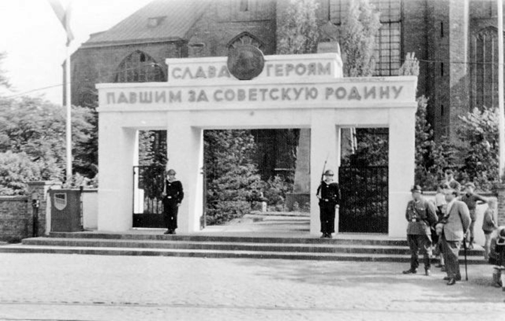
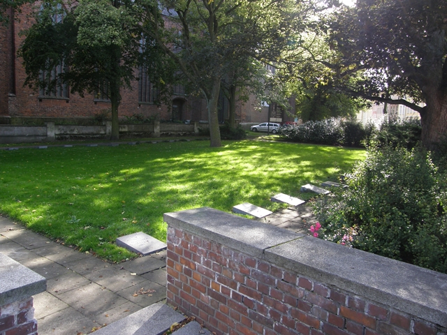
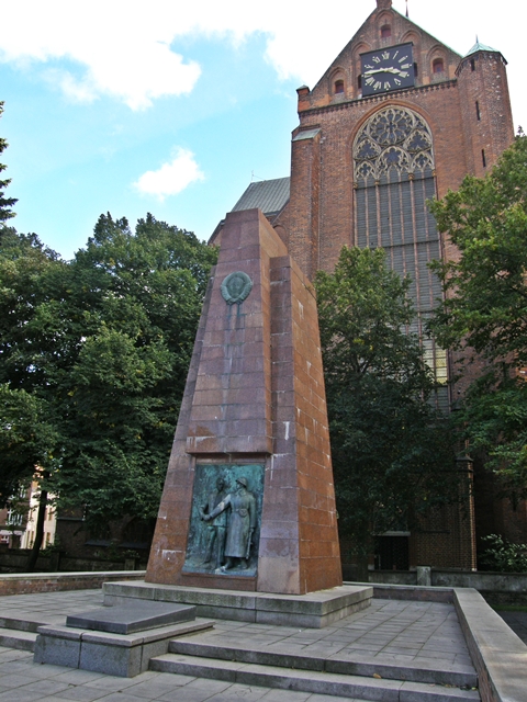
| Description | : | The Sowjetischer Ehrenfriedhof (Russian War Cemetery) is located just north of the St.-Marien-Kirche. The lot used to be part of the old St.-Marien-Kirchhof (St. Mary's Churchyard), which was closed and turned into a small park at the end of the 19th century. In 1945 the Russian army established an honor field at this site with graves for fallen soldiers of the Russian Army. Originally an arch marked the entrance to this cemetery, but that one was demolished in 1967 and now an obelisk serves as the Memorial for the Unknown Soldier. Other burial grounds in Stralsund: Sankt-Jürgen-Friedhof Zentralfriedhof Stralsund Sankt-Marien-Kirche Stralsund Jewish Cemetery of Stralsund Sankt-Jacobi-Kirchhof... Read More |
frequently asked questions (FAQ):
-
Where is Sowjetischer Ehrenfriedhof Stralsund?
Sowjetischer Ehrenfriedhof Stralsund is located at Neuer Markt Stralsund, Landkreis Vorpommern-Rügen ,Mecklenburg-Vorpommern , 18435Germany.
-
Sowjetischer Ehrenfriedhof Stralsund cemetery's updated grave count on graveviews.com?
0 memorials
-
Where are the coordinates of the Sowjetischer Ehrenfriedhof Stralsund?
Latitude: 54.3105020
Longitude: 13.0881180
Nearby Cemetories:
1. Sankt-Marien-Kirche Stralsund
Stralsund, Landkreis Vorpommern-Rügen, Germany
Coordinate: 54.3099330, 13.0879310
2. Sankt-Marien-Kirchhof Stralsund
Stralsund, Landkreis Vorpommern-Rügen, Germany
Coordinate: 54.3098620, 13.0870560
3. Sankt-Jacobi-Kirchhof Stralsund
Stralsund, Landkreis Vorpommern-Rügen, Germany
Coordinate: 54.3130810, 13.0919590
4. Frankenfriedhof
Stralsund, Landkreis Vorpommern-Rügen, Germany
Coordinate: 54.3027798, 13.0942589
5. Saint Jurgen Friedhof
Stralsund, Landkreis Vorpommern-Rügen, Germany
Coordinate: 54.3239670, 13.0759190
6. Jüdischer Friedhof Stralsund
Stralsund, Landkreis Vorpommern-Rügen, Germany
Coordinate: 54.2909470, 13.0935840
7. Zentralfriedhof Stralsund
Stralsund, Landkreis Vorpommern-Rügen, Germany
Coordinate: 54.3312820, 13.0632160
8. Dorfkirche Voigdehagen
Voigdehagen, Landkreis Vorpommern-Rügen, Germany
Coordinate: 54.2699720, 13.0933610
9. Friedhof Rügen-Gustow
Gustow, Landkreis Vorpommern-Rügen, Germany
Coordinate: 54.3018300, 13.2137000
10. Friedhof Rügen-Rambin
Rambin, Landkreis Vorpommern-Rügen, Germany
Coordinate: 54.3550600, 13.2048300
11. St.-Johannes-Kirche zu Rambin
Rambin, Landkreis Vorpommern-Rügen, Germany
Coordinate: 54.3550560, 13.2048370
12. Friedhof Rügen-Poseritz
Poseritz, Landkreis Vorpommern-Rügen, Germany
Coordinate: 54.2981300, 13.2768800
13. Abtshagen
Abtshagen, Landkreis Vorpommern-Rügen, Germany
Coordinate: 54.1905300, 13.0200500
14. Friedhof Rügen-Swantow
Landkreis Vorpommern-Rügen, Germany
Coordinate: 54.2889500, 13.3253400
15. Friedhof Rügen-Garz
Landkreis Vorpommern-Rügen, Germany
Coordinate: 54.3149800, 13.3556400
16. Friedhof Rügen-Kasnevitz
Landkreis Vorpommern-Rügen, Germany
Coordinate: 54.3397400, 13.4162100
17. Dorfkirche Starkow St. Jürgen
Starkow, Landkreis Vorpommern-Rügen, Germany
Coordinate: 54.2752339, 12.7518441
18. St. Marienkirche Kenz
Stralsund, Landkreis Vorpommern-Rügen, Germany
Coordinate: 54.3263440, 12.7359760
19. Sankt-Marien-Kirche
Barth, Landkreis Vorpommern-Rügen, Germany
Coordinate: 54.3691343, 12.7244318
20. Friedhof Rügen-Putbus
Landkreis Vorpommern-Rügen, Germany
Coordinate: 54.3539200, 13.4623500
21. Ev. Kirchengemeinde Bergen Friedhöfe
Landkreis Vorpommern-Rügen, Germany
Coordinate: 54.4122900, 13.4339200
22. St.-Margarethen-Kirche
Patzig, Landkreis Vorpommern-Rügen, Germany
Coordinate: 54.4647000, 13.3964530
23. Alter Friedhof
Neuenkirchen, Landkreis Vorpommern-Greifswald, Germany
Coordinate: 54.1186957, 13.3758868
24. Peter-Pauls-Friedhof Zingst
Zingst, Landkreis Vorpommern-Rügen, Germany
Coordinate: 54.4382951, 12.6888619