
| Memorials | : | 0 |
| Location | : | Windsor, Windsor and Maidenhead Royal Borough, England |
| Coordinate | : | 51.4790700, -0.5903400 |
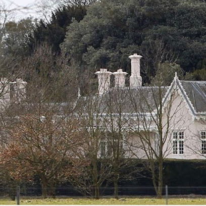
| Description | : | Adelaide Cottage (formerly, Adelaide Lodge) is a historic house in Windsor Home Park just east of Windsor Castle in the United Kingdom. Incorporating parts of John Nash's Royal Lodge from Windsor Great Park, it was re-erected in 1831, in the picturesque style for Queen Adelaide. Architect Jeffry Wyatville oversaw the construction. When it was first built, the house was described as "chastely elegant" and having two rooms, in addition to a retiring room for the Queen, and a pages' room, as well as furnishings from the former royal lodge and a marble fireplace mantel in the regency Graeco-Egyptian style. The... Read More |
frequently asked questions (FAQ):
-
Where is Adelaide Cottage?
Adelaide Cottage is located at Windsor Home Park Windsor, Windsor and Maidenhead Royal Borough ,Berkshire ,England.
-
Adelaide Cottage cemetery's updated grave count on graveviews.com?
0 memorials
-
Where are the coordinates of the Adelaide Cottage?
Latitude: 51.4790700
Longitude: -0.5903400
Nearby Cemetories:
1. Slopes of Windsor
Windsor, Windsor and Maidenhead Royal Borough, England
Coordinate: 51.4850000, -0.5950000
2. Royal Burial Ground
Windsor, Windsor and Maidenhead Royal Borough, England
Coordinate: 51.4740562, -0.5986640
3. St. Mary the Virgin Churchyard
Datchet, Windsor and Maidenhead Royal Borough, England
Coordinate: 51.4843260, -0.5782760
4. Albert Memorial Chapel
Windsor, Windsor and Maidenhead Royal Borough, England
Coordinate: 51.4837180, -0.6061340
5. St. George's Chapel
Windsor, Windsor and Maidenhead Royal Borough, England
Coordinate: 51.4835910, -0.6068820
6. St John the Baptist Churchyard
Windsor, Windsor and Maidenhead Royal Borough, England
Coordinate: 51.4786250, -0.6136450
7. Datchet Parish Council Cemetery
Datchet, Windsor and Maidenhead Royal Borough, England
Coordinate: 51.4836530, -0.5657230
8. Eton College Chapel
Eton, Windsor and Maidenhead Royal Borough, England
Coordinate: 51.4915352, -0.6087430
9. Church Road Cemetery
Old Windsor, Windsor and Maidenhead Royal Borough, England
Coordinate: 51.4622500, -0.5805900
10. St John the Evangelist Cemetery
Eton, Windsor and Maidenhead Royal Borough, England
Coordinate: 51.4927100, -0.6142100
11. St. Peter and St. Andrew Churchyard
Old Windsor, Windsor and Maidenhead Royal Borough, England
Coordinate: 51.4621120, -0.5727310
12. Eton Parish Cemetery
Eton, Windsor and Maidenhead Royal Borough, England
Coordinate: 51.4929619, -0.6140140
13. Windsor Cemetery
Windsor, Windsor and Maidenhead Royal Borough, England
Coordinate: 51.4703170, -0.6231090
14. St Andrew the Apostle Churchyard
Clewer, Windsor and Maidenhead Royal Borough, England
Coordinate: 51.4856620, -0.6246920
15. St. Laurence Churchyard
Upton, Slough Borough, England
Coordinate: 51.5023140, -0.5883950
16. Saint Andrew's Churchyard
Wraysbury, Windsor and Maidenhead Royal Borough, England
Coordinate: 51.4558200, -0.5600900
17. St John the Baptist Churchyard
Eton, Windsor and Maidenhead Royal Borough, England
Coordinate: 51.4958960, -0.6303240
18. St Mary Churchyard
Slough, Slough Borough, England
Coordinate: 51.5090790, -0.5991854
19. St Michael Churchyard
Horton, Windsor and Maidenhead Royal Borough, England
Coordinate: 51.4728500, -0.5403800
20. St Michael's Churchyard
Horton, Aylesbury Vale District, England
Coordinate: 51.4725400, -0.5402620
21. St Mary the Virgin Churchyard
Langley, Slough Borough, England
Coordinate: 51.5057940, -0.5536500
22. St Mary Magdalene Churchyard Boveney
South Bucks District, England
Coordinate: 51.4902860, -0.6474170
23. Slough Cemetery and Crematorium
Slough, Slough Borough, England
Coordinate: 51.5216350, -0.5917440
24. Saint Thomas Churchyard
Colnbrook, Slough Borough, England
Coordinate: 51.4845890, -0.5219910