
| Memorials | : | 0 |
| Location | : | Powiat żagański, Poland |
| Coordinate | : | 51.6183556, 15.3080832 |
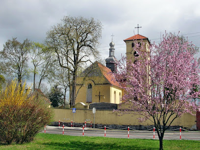
| Description | : | The Church of the Visitation of the Blessed Virgin in Żagań (formerly Sagan) was founded at the site where the Augustinian abbot Ludolf found a pole with the image of the Virgin Mary. A wooden chapel was constructed in 1404, followed by a permanent church in 1444. The structure was destroyed in the Thirty Years War, and was rebuilt in 1691. The church is surrounded by an active graveyard, established in the 16th century. The graveyard was enlarged in 1847 and contains a replica of the Holy Sepulchre in Jerusalem. |
frequently asked questions (FAQ):
-
Where is Żagań Church of the Visitation?
Żagań Church of the Visitation is located at ul. Podgórna, Żagań Powiat żagański ,Lubuskie ,Poland.
-
Żagań Church of the Visitation cemetery's updated grave count on graveviews.com?
0 memorials
-
Where are the coordinates of the Żagań Church of the Visitation?
Latitude: 51.6183556
Longitude: 15.3080832
Nearby Cemetories:
1. Klasztor Augustianów
Powiat żagański, Poland
Coordinate: 51.6159360, 15.3191850
2. Evangelical Church of Grace
Szprotawa, Powiat żagański, Poland
Coordinate: 51.6186110, 15.3213890
3. Żagań Communal Cemetery
Szprotawa, Powiat żagański, Poland
Coordinate: 51.6190600, 15.3325800
4. Dzietrzychowice Church of St. John the Baptist
Powiat żagański, Poland
Coordinate: 51.6644125, 15.3553497
5. Złotnik Communal Cemetery
Powiat żarski, Poland
Coordinate: 51.6925183, 15.2038111
6. Iłowa Communal Cemetery
Szprotawa, Powiat żagański, Poland
Coordinate: 51.5000700, 15.2051100
7. Iłowa Church of the Christ the King
Powiat żagański, Poland
Coordinate: 51.5006459, 15.2033924
8. Church of the Assumption
Szprotawa, Powiat żagański, Poland
Coordinate: 51.5648500, 15.5374000
9. Szprotawa Communal Cemetery
Zielona Góra, Miasto Zielona Góra, Poland
Coordinate: 51.5624339, 15.5557872
10. Białowice Church of the Sacred Heart of Jesus
Powiat zielonogórski, Poland
Coordinate: 51.7688294, 15.1733025
11. Mirocin Górny Communal Cemetery
Zielona Góra, Miasto Zielona Góra, Poland
Coordinate: 51.7541006, 15.5246106
12. Borów Wielki Church of St. Lawrence
Zielona Góra, Miasto Zielona Góra, Poland
Coordinate: 51.6799688, 15.6320039
13. Kożuchów Old Protestant Cemetery
Zielona Góra, Miasto Zielona Góra, Poland
Coordinate: 51.7433548, 15.5895350
14. Dugie Communal Cemetery
Powiat żagański, Poland
Coordinate: 51.6519933, 15.6506009
15. Gozdnica Communal Cemetery
Powiat żagański, Poland
Coordinate: 51.4348363, 15.0957059
16. Solniki Church of St. Anne
Powiat nowosolski, Poland
Coordinate: 51.7193945, 15.6566670
17. Studzieniec Communal Cemetery
Zielona Góra, Miasto Zielona Góra, Poland
Coordinate: 51.8009748, 15.5669361
18. Stara Oleszna Catholic Cemetery
Bolesławiec, Powiat bolesławiecki, Poland
Coordinate: 51.4113100, 15.5994600
19. Stara Oleszna Evangelical Cemetery
Bolesławiec, Powiat bolesławiecki, Poland
Coordinate: 51.4122400, 15.6021400
20. Rudno Church of St. Simon and St. Jude Thaddeus
Powiat nowosolski, Poland
Coordinate: 51.7848967, 15.6799890
21. Stara Jabłona Protestant Cemetery
Zielona Góra, Miasto Zielona Góra, Poland
Coordinate: 51.6276410, 15.7704773
22. Kliczków Old Cemetery
Bolesławiec, Powiat bolesławiecki, Poland
Coordinate: 51.3284500, 15.4334700
23. Jędrzychów Communal Cemetery
Zielona Góra, Miasto Zielona Góra, Poland
Coordinate: 51.9069430, 15.5018058
24. Cmentarz Komunalny w Nowej Soli
Powiat nowosolski, Poland
Coordinate: 51.8085928, 15.7220024