
| Memorials | : | 0 |
| Location | : | Powiat żagański, Poland |
| Coordinate | : | 51.5006459, 15.2033924 |
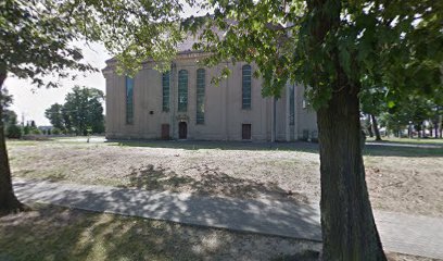
| Description | : | The Church of Christ the King in Iłowa (prior to 1945: Halbau) was constructed as a Protestant church between 1720-1725 according to a design by Giovanni Simonetti. In 1749 it suffered a severe fire and had to be rebuilt. The church was abandoned following the expulsion of the city's German population after WWII, and was eventually taken over by the Catholic Church, who maintain it today. The church has a number of epitaphs and gravestones on its walls from the 17th-18th centuries, several of which predate the current structure. |
frequently asked questions (FAQ):
-
Where is Iłowa Church of the Christ the King?
Iłowa Church of the Christ the King is located at ul. Adama Mickiewicza, Iłowa Powiat żagański ,Lubuskie ,Poland.
-
Iłowa Church of the Christ the King cemetery's updated grave count on graveviews.com?
0 memorials
-
Where are the coordinates of the Iłowa Church of the Christ the King?
Latitude: 51.5006459
Longitude: 15.2033924
Nearby Cemetories:
1. Iłowa Communal Cemetery
Szprotawa, Powiat żagański, Poland
Coordinate: 51.5000700, 15.2051100
2. Gozdnica Communal Cemetery
Powiat żagański, Poland
Coordinate: 51.4348363, 15.0957059
3. Żagań Church of the Visitation
Powiat żagański, Poland
Coordinate: 51.6183556, 15.3080832
4. Klasztor Augustianów
Powiat żagański, Poland
Coordinate: 51.6159360, 15.3191850
5. Evangelical Church of Grace
Szprotawa, Powiat żagański, Poland
Coordinate: 51.6186110, 15.3213890
6. Żagań Communal Cemetery
Szprotawa, Powiat żagański, Poland
Coordinate: 51.6190600, 15.3325800
7. Dzietrzychowice Church of St. John the Baptist
Powiat żagański, Poland
Coordinate: 51.6644125, 15.3553497
8. Złotnik Communal Cemetery
Powiat żarski, Poland
Coordinate: 51.6925183, 15.2038111
9. Stary Węgliniec Old Cemetery
Bolesławiec, Powiat bolesławiecki, Poland
Coordinate: 51.3051300, 15.1994300
10. Church of the Assumption
Szprotawa, Powiat żagański, Poland
Coordinate: 51.5648500, 15.5374000
11. Kliczków Old Cemetery
Bolesławiec, Powiat bolesławiecki, Poland
Coordinate: 51.3284500, 15.4334700
12. Szprotawa Communal Cemetery
Zielona Góra, Miasto Zielona Góra, Poland
Coordinate: 51.5624339, 15.5557872
13. Tomisław Communal Cemetery
Bolesławiec, Powiat bolesławiecki, Poland
Coordinate: 51.2937300, 15.4240900
14. Tomisław Church Graveyard
Bolesławiec, Powiat bolesławiecki, Poland
Coordinate: 51.2933700, 15.4283100
15. Czerwona Woda Church Graveyard
Bolesławiec, Powiat bolesławiecki, Poland
Coordinate: 51.2489900, 15.2138700
16. Pieńsk Communal Cemetery
Bolesławiec, Powiat bolesławiecki, Poland
Coordinate: 51.2631500, 15.0469800
17. Stara Oleszna Catholic Cemetery
Bolesławiec, Powiat bolesławiecki, Poland
Coordinate: 51.4113100, 15.5994600
18. Stara Oleszna Evangelical Cemetery
Bolesławiec, Powiat bolesławiecki, Poland
Coordinate: 51.4122400, 15.6021400
19. Białowice Church of the Sacred Heart of Jesus
Powiat zielonogórski, Poland
Coordinate: 51.7688294, 15.1733025
20. Wykroty Church Graveyard
Bolesławiec, Powiat bolesławiecki, Poland
Coordinate: 51.2330400, 15.2739600
21. Friedhof Sagar
Krauschwitz, Burgenlandkreis, Germany
Coordinate: 51.5158600, 14.7561570
22. Dłużyna Dolna Communal Cemetery
Wrocław, Miasto Wrocław, Poland
Coordinate: 51.2243300, 15.1232100
23. Bielawa Górna Church Graveyard
Wrocław, Miasto Wrocław, Poland
Coordinate: 51.1999400, 15.1945800
24. Alter Friedhof
Bad Muskau, Landkreis Görlitz, Germany
Coordinate: 51.5539699, 14.7070045