
| Memorials | : | 0 |
| Location | : | Tucson, Pima County, USA |
| Website | : | www.pima.gov/JointCourts/Photos/Rep_Reburials.html |
| Coordinate | : | 32.2248500, -110.9711220 |
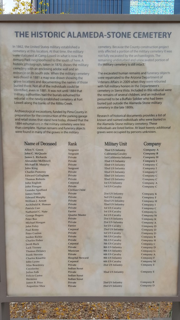
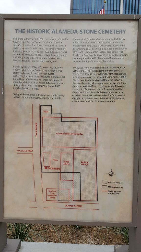
| Description | : | The National Cemetery, today called the Alameda-Stone Cemetery, is a defunct cemetery located in downtown Tucson. It consisted of a walled military cemetery, with a larger civilian cemetery that surrounded the north and east portions of the military cemetery. The military cemetery was in use from 1862 through 1881. Most of the military burials were exhumed in 1884 and were taken to the Fort Lowell Cemetery, located several miles to the east. Many of these were subsequently exhumed in 1891 and taken to the San Francisco Presidio. The civilian portion was in use from probably the late 1850s to early 1860s... Read More |
frequently asked questions (FAQ):
-
Where is Alameda-Stone Cemetery?
Alameda-Stone Cemetery is located at N Stone Avenue and E Alameda Street Tucson, Pima County ,Arizona , 85701USA.
-
Alameda-Stone Cemetery cemetery's updated grave count on graveviews.com?
0 memorials
-
Where are the coordinates of the Alameda-Stone Cemetery?
Latitude: 32.2248500
Longitude: -110.9711220
Nearby Cemetories:
1. Presidio San Agustin del Tucson Cemetery
Tucson, Pima County, USA
Coordinate: 32.2236840, -110.9732440
2. Cathedral of Saint Augustine Altar Crypt
Tucson, Pima County, USA
Coordinate: 32.2194500, -110.9709800
3. Camp Lowell Post Cemetery
Tucson, Pima County, USA
Coordinate: 32.2190400, -110.9681700
4. Trinity Presbyterian Church Memorial Garden
Tucson, Pima County, USA
Coordinate: 32.2312540, -110.9652820
5. Court Street Cemetery
Tucson, Pima County, USA
Coordinate: 32.2342030, -110.9748640
6. Saint Andrews Episcopal Church Columbarium
Tucson, Pima County, USA
Coordinate: 32.2148410, -110.9666540
7. First United Methodist Church Memorial Garden
Tucson, Pima County, USA
Coordinate: 32.2310090, -110.9572230
8. Our Saviour's Lutheran Church Memorial Garden
Tucson, Pima County, USA
Coordinate: 32.2379180, -110.9430730
9. Grace Saint Pauls Memorial Garden
Tucson, Pima County, USA
Coordinate: 32.2409000, -110.9370000
10. Catalina United Methodist Church Memorial Garden
Tucson, Pima County, USA
Coordinate: 32.2350650, -110.9313480
11. Evergreen Memorial Park
Tucson, Pima County, USA
Coordinate: 32.2623860, -110.9822510
12. Pima County Cemetery
Tucson, Pima County, USA
Coordinate: 32.2658997, -110.9850006
13. Holy Hope Cemetery and Mausoleum
Tucson, Pima County, USA
Coordinate: 32.2696991, -110.9831009
14. Saint James UMC Memorial Garden
Tucson, Pima County, USA
Coordinate: 32.2665390, -110.9443690
15. Northminster Presbyterian Church Cemetery
Tucson, Pima County, USA
Coordinate: 32.2645000, -110.9359000
16. Saint Marks Presbyterian Church Cemetery
Tucson, Pima County, USA
Coordinate: 32.2330170, -110.9119560
17. Saint Philips in the Hills Church Columbarium
Tucson, Pima County, USA
Coordinate: 32.2877007, -110.9433975
18. Fort Lowell Cemetery
Tucson, Pima County, USA
Coordinate: 32.2616000, -110.8961000
19. Ahmadiyya Muslim Cemetery
Tucson, Pima County, USA
Coordinate: 32.1520360, -110.9513440
20. South Lawn Memorial Cemetery
Tucson, Pima County, USA
Coordinate: 32.1521988, -110.9494019
21. Binghampton Cemetery
Tucson, Pima County, USA
Coordinate: 32.2797012, -110.9100037
22. Christ Church United Methodist Memorial Garden
Tucson, Pima County, USA
Coordinate: 32.2304100, -110.8757900
23. Rincon Congregational Church Columbarium
Tucson, Pima County, USA
Coordinate: 32.2241880, -110.8749300
24. Dove of Peace Lutheran Church Memorial Garden
Tucson, Pima County, USA
Coordinate: 32.3089160, -110.9803890