
| Memorials | : | 5 |
| Location | : | Dodge City, Ford County, USA |
| Coordinate | : | 37.6639500, -100.0913300 |
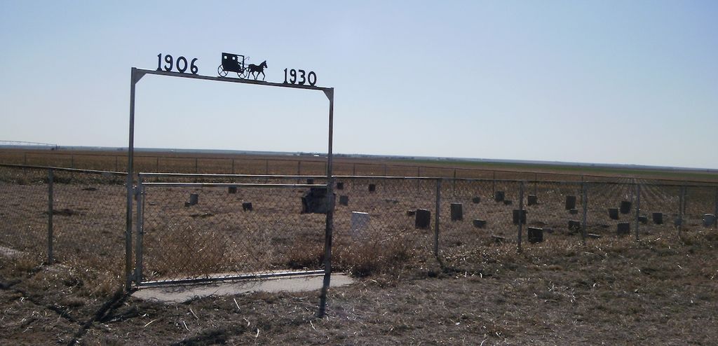
| Description | : | The best way to locate the grave yard. 60 South out of Dodge, seven miles to first black top, cross road, turn west go four miles, turn north go one mile, turn west go one half mile, grave yard on South Side. |
frequently asked questions (FAQ):
-
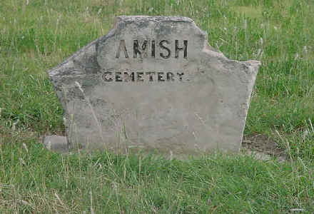
Where is Amish Cemetery?
Amish Cemetery is located at Dodge City, Ford County ,Kansas ,USA.
-
Amish Cemetery cemetery's updated grave count on graveviews.com?
3 memorials
-
Where are the coordinates of the Amish Cemetery?
Latitude: 37.6639500
Longitude: -100.0913300
Nearby Cemetories:
1. Christ the King Cemetery
Ford County, USA
Coordinate: 37.6493073, -100.0056305
2. Concord Cemetery
Ford County, USA
Coordinate: 37.5910988, -100.1157990
3. Scroggins Mausoleum
Dodge City, Ford County, USA
Coordinate: 37.7403000, -100.0498200
4. Maple Grove Cemetery
Dodge City, Ford County, USA
Coordinate: 37.7612410, -100.0507630
5. Boot Hill Cemetery (Defunct)
Dodge City, Ford County, USA
Coordinate: 37.7544800, -100.0222800
6. Johnson Cemetery
Ensign, Gray County, USA
Coordinate: 37.7086010, -100.2156130
7. Prairie Grove Cemetery (Defunct)
Dodge City, Ford County, USA
Coordinate: 37.7612600, -100.0129500
8. Ensign Cemetery
Ensign, Gray County, USA
Coordinate: 37.6274986, -100.2339020
9. Kansas Veterans Cemetery at Fort Dodge
Dodge City, Ford County, USA
Coordinate: 37.7315903, -99.9314041
10. German Mission Schlichting Cemetery
Dodge City, Ford County, USA
Coordinate: 37.5030530, -100.0886890
11. Cave Cemetery
Gray County, USA
Coordinate: 37.5469017, -100.2518997
12. Ridenhour Cemetery
Ford County, USA
Coordinate: 37.8396988, -100.1716995
13. Wilburn Cemetery
Fowler, Meade County, USA
Coordinate: 37.4742012, -100.1264038
14. Pleasant Vale Cemetery
Ford County, USA
Coordinate: 37.7933006, -99.9047012
15. Saint Andrew Catholic Cemetery
Wright, Ford County, USA
Coordinate: 37.7790800, -99.8875100
16. McCauley Cemetery
Fowler, Meade County, USA
Coordinate: 37.4609000, -100.2155800
17. First Congregational Church Cemetery
Fowler, Meade County, USA
Coordinate: 37.4606400, -100.2152600
18. Bloom Cemetery
Bloom, Ford County, USA
Coordinate: 37.4928017, -99.8966980
19. Cimarron Cemetery
Cimarron, Gray County, USA
Coordinate: 37.8178200, -100.3411900
20. Fairview Cemetery
Montezuma, Gray County, USA
Coordinate: 37.6431007, -100.4147034
21. Cimarron Cemetery Foote Addition
Cimarron, Gray County, USA
Coordinate: 37.8265700, -100.3452900
22. Pioneer Cemetery
Wright, Ford County, USA
Coordinate: 37.7783360, -99.7872570
23. Appleton Township Cemetery
Minneola, Clark County, USA
Coordinate: 37.4011002, -100.0046997
24. Ford Cemetery
Ford, Ford County, USA
Coordinate: 37.6319008, -99.7431030