
| Memorials | : | 4 |
| Location | : | Scotland |
| Coordinate | : | 55.9867390, -2.7499130 |
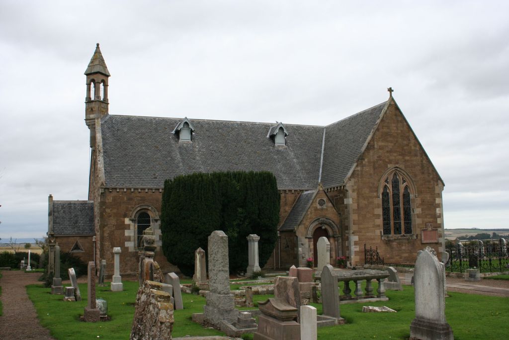
| Description | : | Athelstaneford is a village in East Lothian, Scotland and lies almost 3.5 miles north-east of the market town of Haddington and approximately 17 miles east of Edinburgh. According to popular legend, Athelstaneford is where the original Scottish saltire - the white diagonal cross on a sky blue background - was first adopted. |
frequently asked questions (FAQ):
-
Where is Athelstaneford Parish Church Cemetery?
Athelstaneford Parish Church Cemetery is located at Main Street East Lothian , EH39 5BEScotland.
-
Athelstaneford Parish Church Cemetery cemetery's updated grave count on graveviews.com?
4 memorials
-
Where are the coordinates of the Athelstaneford Parish Church Cemetery?
Latitude: 55.9867390
Longitude: -2.7499130

Nearby Cemetories:
1. Cranstoun Parish Churchyard
Scotland
Coordinate: 55.8792400, -2.9860300
2. Longformacus Parish Church
Scotland
Coordinate: 55.8080300, -2.4898700
3. Abercrombie Old Chapelyard
Scotland
Coordinate: 56.2210500, -2.7725053
4. Largo Cemetery
Scotland
Coordinate: 56.2230510, -2.9332210
5. Penicuik Old Churchyard
Scotland
Coordinate: 55.8270580, -3.2193700
6. Cults Cemetery
Scotland
Coordinate: 56.2767906, -3.0565600
7. St. Serf's Priory
Scotland
Coordinate: 56.1876160, -3.3529760
8. St Cuthbert Churchyard
Carham, Northumberland Unitary Authority, England
Coordinate: 55.6389230, -2.3238090
9. Ecclesmachan Cemetery
Scotland
Coordinate: 55.9461400, -3.5096500
10. Abdie Churchyard
Scotland
Coordinate: 56.3338200, -3.1993100
11. Creich Cemetery
Scotland
Coordinate: 56.3798110, -3.0912140
12. St Helen's Churchyard
Cornhill-on-Tweed, Northumberland Unitary Authority, England
Coordinate: 55.6464840, -2.2264990
13. Berwick-upon-Tweed Cemetery
Berwick-upon-Tweed, Northumberland Unitary Authority, England
Coordinate: 55.7799800, -2.0107500
14. Berwick Parish Church
Berwick-upon-Tweed, Northumberland Unitary Authority, England
Coordinate: 55.7721130, -2.0010390
15. Our Lady & St. Cuthbert's
Berwick-upon-Tweed, Northumberland Unitary Authority, England
Coordinate: 55.7695760, -1.9994210
16. All Saints Churchyard
Duddo, Northumberland Unitary Authority, England
Coordinate: 55.6859800, -2.0862900
17. St Paul's Churchyard
Branxton, Northumberland Unitary Authority, England
Coordinate: 55.6308820, -2.1726490
18. Flodden Field Cemetery
Branxton, Northumberland Unitary Authority, England
Coordinate: 55.6287730, -2.1765120
19. Mindrum Churchyard
Mindrum, Northumberland Unitary Authority, England
Coordinate: 55.5937100, -2.2481000
20. St. Mary the Virgin Chapelyard
Etal, Northumberland Unitary Authority, England
Coordinate: 55.6481100, -2.1150200
21. St. Anne's Churchyard
Ancroft, Northumberland Unitary Authority, England
Coordinate: 55.7000400, -1.9981800
22. St Michael and All Angels Churchyard
Ford, Northumberland Unitary Authority, England
Coordinate: 55.6301700, -2.0895430
23. Muiravonside Church of Scotland
Scotland
Coordinate: 55.9743440, -3.6742900
24. St Gregory Churchyard
Kirknewton, Northumberland Unitary Authority, England
Coordinate: 55.5658590, -2.1387780