| Memorials | : | 0 |
| Location | : | Pollards Corner, Columbia County, USA |
| Coordinate | : | 33.6259290, -82.2661600 |
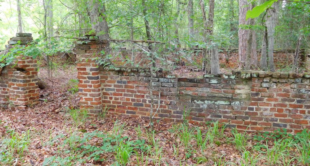
| Description | : | Cemetery Access is on gated property owned by Pollard Lumber Co. Drive north on Hwy 150/221 from Pollards Corner intersection about .6 mile and turn right onto a dirt road with a locked vehicle gate. Once gate access is permitted, cemetery is approximately .4 mile from highway. The cemetery is in bad condition as time and remote location has taken its toll. It is approximately 15x25 ft in size and encircled by a brick wall. No pedestrian gate exists now as you can see from the photo on this page. Although only one marker is upright and clearly visible,... Read More |
frequently asked questions (FAQ):
-
Where is Bailey Family Cemetery?
Bailey Family Cemetery is located at Pollards Corner, Columbia County ,Georgia ,USA.
-
Bailey Family Cemetery cemetery's updated grave count on graveviews.com?
0 memorials
-
Where are the coordinates of the Bailey Family Cemetery?
Latitude: 33.6259290
Longitude: -82.2661600
Nearby Cemetories:
1. Luke-Lamkin Cemetery
Columbia County, USA
Coordinate: 33.6208485, -82.2775860
2. Reid Family Cemetery
Columbia County, USA
Coordinate: 33.6180100, -82.2570000
3. Bethel Cemetery
Columbia County, USA
Coordinate: 33.6405983, -82.2593994
4. Second Mount Carmel Baptist Church Cemetery
Columbia County, USA
Coordinate: 33.6230730, -82.2394980
5. Germany Cemetery
Appling, Columbia County, USA
Coordinate: 33.6011586, -82.2629671
6. Blount-Pullin Cemetery
Columbia County, USA
Coordinate: 33.5968611, -82.2680000
7. Canaan of Galilee Baptist Church Cemetery
Appling, Columbia County, USA
Coordinate: 33.6527350, -82.2434650
8. Avary Family Cemetery
Columbia County, USA
Coordinate: 33.6236600, -82.2144400
9. Spring Grove Cemetery
Columbia County, USA
Coordinate: 33.6516991, -82.2228012
10. Solid Rock Baptist Church Cemetery
Appling, Columbia County, USA
Coordinate: 33.5876338, -82.2951234
11. Walnut Grove Baptist Church Cemetery
Appling, Columbia County, USA
Coordinate: 33.6058760, -82.3210050
12. Friendship Baptist Church Cemetery
Appling, Columbia County, USA
Coordinate: 33.5947820, -82.2183810
13. Kelley-Lamkin Cemetery
Appling, Columbia County, USA
Coordinate: 33.5741530, -82.2651100
14. Old Avery Cemetery
Columbia County, USA
Coordinate: 33.6192017, -82.2035980
15. Old Kiokee Baptist Church Cemetery
Appling, Columbia County, USA
Coordinate: 33.5779000, -82.2917900
16. Knox Cemetery
Columbia County, USA
Coordinate: 33.5732994, -82.2463989
17. Rehoboth Baptist Church Cemetery
Appling, Columbia County, USA
Coordinate: 33.6662423, -82.3131795
18. Harriss Family Cemetery
Appling, Columbia County, USA
Coordinate: 33.5901100, -82.3184100
19. Damascus Baptist Church Cemetery
Appling, Columbia County, USA
Coordinate: 33.6661220, -82.3169520
20. Lampkin Grove Baptist Church Cemetery
Appling, Columbia County, USA
Coordinate: 33.5665000, -82.2515500
21. Blanchard Cemetery
Columbia County, USA
Coordinate: 33.6274986, -82.3399963
22. Crawford Family Cemetery
Appling, Columbia County, USA
Coordinate: 33.5910700, -82.3331500
23. Dunn's Chapel Cemetery
Dunn Chapel, Columbia County, USA
Coordinate: 33.6576700, -82.3375300
24. Thomas Hardin Family Cemetery
Leah, Columbia County, USA
Coordinate: 33.6774370, -82.3317050

