
| Memorials | : | 68 |
| Location | : | Coshocton County, USA |
| Coordinate | : | 40.3564571, -81.6520681 |
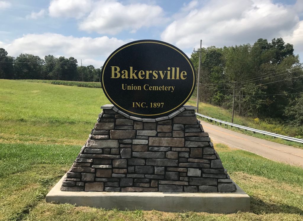
| Description | : | The cemetery is located just west of Bakersville on the south side of County Road 2 about 0.3 mile west of its intersection with Township Road 281. The cemetery is 2 acres in size. The cemetery is located in Adams Township, Coshocton County, Ohio, and is # 2176 (Bakersville Cemetery) in “Ohio Cemeteries 1803-2003”, compiled by the Ohio Genealogical Society. The U.S. Geological Survey (USGS) Geographic Names Information System (GNIS) feature ID for the cemetery is 1964097 (Bakersville Cemetery). |
frequently asked questions (FAQ):
-
Where is Bakersville Cemetery?
Bakersville Cemetery is located at County Road 2 Coshocton County ,Ohio , 43832USA.
-
Bakersville Cemetery cemetery's updated grave count on graveviews.com?
68 memorials
-
Where are the coordinates of the Bakersville Cemetery?
Latitude: 40.3564571
Longitude: -81.6520681
Nearby Cemetories:
1. Salem Amish-Mennonite Church Cemetery
Newcomerstown, Tuscarawas County, USA
Coordinate: 40.3560480, -81.6406400
2. Bakersville Presbyterian Cemetery
Bakersville, Coshocton County, USA
Coordinate: 40.3415510, -81.6429950
3. Campbell Cemetery
Bakersville, Coshocton County, USA
Coordinate: 40.3418999, -81.6686020
4. Evans Creek Lutheran Cemetery
Tuscarawas County, USA
Coordinate: 40.3756200, -81.6370700
5. Ebenezer Cemetery
Stone Creek, Tuscarawas County, USA
Coordinate: 40.3716170, -81.6188260
6. Renners Church Cemetery
Tuscarawas County, USA
Coordinate: 40.3738290, -81.6848690
7. Mount Zion Cemetery
Tuscarawas, Tuscarawas County, USA
Coordinate: 40.3577995, -81.6025009
8. Woods College Cemetery
Coshocton County, USA
Coordinate: 40.3405991, -81.6975021
9. Taylor Cemetery
Bakersville, Coshocton County, USA
Coordinate: 40.3177986, -81.6493988
10. McCollum Family Cemetery
Baltic, Tuscarawas County, USA
Coordinate: 40.3848000, -81.6904000
11. McCollum Cemetery
Baltic, Tuscarawas County, USA
Coordinate: 40.3847530, -81.6904810
12. Corbit-Swigert Cemetery
Orange, Coshocton County, USA
Coordinate: 40.3107986, -81.6564026
13. Clapboard Cemetery
Coshocton County, USA
Coordinate: 40.3391991, -81.7244034
14. Saint Jacobs Reformed Cemetery
Tuscarawas County, USA
Coordinate: 40.4047891, -81.6098445
15. Bethel Cemetery
Salem Township, Tuscarawas County, USA
Coordinate: 40.3497009, -81.5730972
16. Fiat Cemetery
Fiat, Tuscarawas County, USA
Coordinate: 40.4175072, -81.6648102
17. Fairview Cemetery
Fresno, Coshocton County, USA
Coordinate: 40.3238983, -81.7328033
18. Everal Chapel Cemetery
Coshocton County, USA
Coordinate: 40.2882110, -81.6320300
19. Kimball Cemetery
Fresno, Coshocton County, USA
Coordinate: 40.3541985, -81.7442017
20. Evansburg Cemetery
Orange, Coshocton County, USA
Coordinate: 40.2873300, -81.6771800
21. Powell's Cemetery
Coshocton, Coshocton County, USA
Coordinate: 40.3301239, -81.7438202
22. Bowman Cemetery
West Lafayette, Coshocton County, USA
Coordinate: 40.3031006, -81.7247009
23. Mount Zion Lutheran Church Cemetery
Chili, Coshocton County, USA
Coordinate: 40.3792266, -81.7495691
24. Halifax Cemetery
Coshocton, Coshocton County, USA
Coordinate: 40.4087030, -81.7294830