
| Memorials | : | 66 |
| Location | : | Hornsby Shire, Australia |
| Coordinate | : | -33.5262140, 151.1528610 |
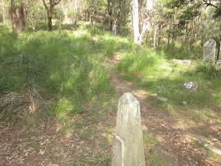
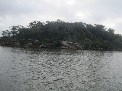
| Description | : | Bar Island, traditionally part of the land of the Dharug and Darkinjung Aboriginal People, covers an area of abt 3.8 hectares. |
frequently asked questions (FAQ):
-
Where is Bar Island Cemetery?
Bar Island Cemetery is located at entrance to Marramarra Creek, nr Berowra Creek, Hawkesbury River, Hornsby Shire ,New South Wales , 2083Australia.
-
Bar Island Cemetery cemetery's updated grave count on graveviews.com?
66 memorials
-
Where are the coordinates of the Bar Island Cemetery?
Latitude: -33.5262140
Longitude: 151.1528610
Nearby Cemetories:
1. Frances Peat Lone Grave
Mooney Mooney, Central Coast Council, Australia
Coordinate: -33.5333171, 151.1989208
2. Brooklyn General Cemetery
Brooklyn, Hornsby Shire, Australia
Coordinate: -33.5471710, 151.1990020
3. Holy Trinity Church Cemetery
Spencer, Central Coast Council, Australia
Coordinate: -33.4293910, 151.1639380
4. Maloney Gravesite
Glenworth Valley, Central Coast Council, Australia
Coordinate: -33.4039645, 151.1957958
5. Greengrove Saint Peters Cemetery
Greengrove, Central Coast Council, Australia
Coordinate: -33.3803020, 151.1400300
6. Barrenjoey Head
Palm Beach, Northern Beaches Council, Australia
Coordinate: -33.5802716, 151.3300583
7. Church Point Historic Cemetery
Church Point, Northern Beaches Council, Australia
Coordinate: -33.6450120, 151.2841090
8. Point Clare Cemetery
Point Clare, Central Coast Council, Australia
Coordinate: -33.4344800, 151.3128600
9. Veteran Hall
Saratoga, Central Coast Council, Australia
Coordinate: -33.4786400, 151.3452750
10. Point Frederick Pioneer Cemetery
Point Frederick, Central Coast Council, Australia
Coordinate: -33.4498830, 151.3417900
11. The Old Man's Valley Cemetery
Hornsby, Hornsby Shire, Australia
Coordinate: -33.6994480, 151.0923970
12. Avalon Anglican Columbarium
Avalon, Northern Beaches Council, Australia
Coordinate: -33.6333540, 151.3304900
13. Mona Vale Cemetery
Mona Vale, Northern Beaches Council, Australia
Coordinate: -33.6752140, 151.2879720
14. Kincumber South Cemetery
Kincumber South, Central Coast Council, Australia
Coordinate: -33.4880610, 151.3759430
15. Mona Vale Anglican Church
Mona Vale, Northern Beaches Council, Australia
Coordinate: -33.6745924, 151.3031547
16. Greenway Chapel & Memorial Gardens
Kincumber, Central Coast Council, Australia
Coordinate: -33.4639900, 151.3734500
17. Bradys Gully Cemetery
Gosford, Central Coast Council, Australia
Coordinate: -33.4168700, 151.3492720
18. Helys Grave
Wyoming, Central Coast Council, Australia
Coordinate: -33.4031120, 151.3505420
19. St Paul's Anglican Church Cemetery
Kincumber, Central Coast Council, Australia
Coordinate: -33.4697950, 151.3952220
20. Upper Mangrove Saint Thomas Anglican
Upper Mangrove Creek, Central Coast Council, Australia
Coordinate: -33.3108330, 151.1296840
21. Frenchs Forest Cemetery
Davidson, Northern Beaches Council, Australia
Coordinate: -33.7392360, 151.2020750
22. Ebenezer Uniting Cemetery
Windsor, Hawkesbury City, Australia
Coordinate: -33.5360290, 150.8914210
23. St. Thomas Cemetery
Ebenezer, Hawkesbury City, Australia
Coordinate: -33.4862900, 150.8938900
24. Cherrybrook Uniting Church Cemetery
Cherrybrook, Hornsby Shire, Australia
Coordinate: -33.7304230, 151.0428770