
| Memorials | : | 0 |
| Location | : | Zoetermeer, Zoetermeer Municipality, Netherlands |
| Coordinate | : | 52.0494000, 4.5077000 |
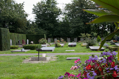
| Description | : | The Begraafplaats Binnenweg was constructed in 1956, because the Kerkhof Oude Kerk was too small, and could not be expanded. In 1966, the cemetery was expanded. In 1974, the municipality Zoetermeer decided to build a new cemetery the Begraafplaats Hoflaan instead of expanding Begraafplaats Binnenweg. |
frequently asked questions (FAQ):
-
Where is Begraafplaats Binnenweg?
Begraafplaats Binnenweg is located at Binnenweg 2 Zoetermeer, Zoetermeer Municipality ,Zuid-Holland , 2712 XENetherlands.
-
Begraafplaats Binnenweg cemetery's updated grave count on graveviews.com?
0 memorials
-
Where are the coordinates of the Begraafplaats Binnenweg?
Latitude: 52.0494000
Longitude: 4.5077000
Nearby Cemetories:
1. Zoetermeer Old Churchyard
Zoetermeer, Zoetermeer Municipality, Netherlands
Coordinate: 52.0562600, 4.4959300
2. Kerkhof RK Sint Nicolaaskerk
Zoetermeer, Zoetermeer Municipality, Netherlands
Coordinate: 52.0575321, 4.4954131
3. Begraafplaats Hoflaan
Zoetermeer, Zoetermeer Municipality, Netherlands
Coordinate: 52.0652820, 4.4638980
4. Crematorium Meerbloemhof
Zoetermeer Municipality, Netherlands
Coordinate: 52.0668059, 4.4615465
5. Begraafplaats Vrederust
Benthuizen, Alphen aan den Rijn Municipality, Netherlands
Coordinate: 52.0745097, 4.5441947
6. Kerkhof Hervormde Kerk Benthuizen
Benthuizen, Alphen aan den Rijn Municipality, Netherlands
Coordinate: 52.0770000, 4.5407400
7. Rooms Katholieke Begraafplaats Bleiswijk
Bleiswijk, Lansingerland Municipality, Netherlands
Coordinate: 52.0146067, 4.5324334
8. Gemeentelijke Begraafplaats Westhage
Moerkapelle, Zuidplas Municipality, Netherlands
Coordinate: 52.0446179, 4.5690196
9. Rooms-Katholieke begraafplaats Berkel en Rodenrijs
Berkel en Rodenrijs, Lansingerland Municipality, Netherlands
Coordinate: 52.0010000, 4.4831400
10. Gemeentelijke Begraafplaats Stompwijk
Stompwijk, Leidschendam-Voorburg Municipality, Netherlands
Coordinate: 52.0952190, 4.4647780
11. RK Begraafplaats H. Joannes de Dooper
Pijnacker, Pijnacker-Nootdorp Municipality, Netherlands
Coordinate: 52.0204000, 4.4328100
12. Nederlands Hervormde Begraafplaats Wilsveen
Wilsveen, Leidschendam-Voorburg Municipality, Netherlands
Coordinate: 52.0738933, 4.4222136
13. Begraafplaats Sint Janshof
Pijnacker-Nootdorp Municipality, Netherlands
Coordinate: 52.0358500, 4.4133597
14. Begraafplaats St. Jans Onthoofding
Zuidbuurt, Zoeterwoude Municipality, Netherlands
Coordinate: 52.1091010, 4.5028680
15. Kerkhof H.H. Engelbewaarderskerk
Hazerswoude-Dorp, Alphen aan den Rijn Municipality, Netherlands
Coordinate: 52.0966540, 4.5834430
16. Algemene Begraafplaats
Hazerswoude-Dorp, Alphen aan den Rijn Municipality, Netherlands
Coordinate: 52.0929000, 4.5898200
17. RK Begraafplaats Sint-Bartholomeüskerk
Nootdorp, Pijnacker-Nootdorp Municipality, Netherlands
Coordinate: 52.0491000, 4.3941100
18. Oude Algemene Begraafplaats Gemeneweg
Hazerswoude-Dorp, Alphen aan den Rijn Municipality, Netherlands
Coordinate: 52.0990941, 4.5915500
19. Nederlands-Hervormde Begraafplaats Dorpskerk
Zoeterwoude-Dorp, Zoeterwoude Municipality, Netherlands
Coordinate: 52.1212195, 4.4971618
20. Rooms Katholieke Begraafplaats Sint Agatha
Leidschendam, Leidschendam-Voorburg Municipality, Netherlands
Coordinate: 52.0934310, 4.4022130
21. Begraafplaats Roemer
Boskoop, Alphen aan den Rijn Municipality, Netherlands
Coordinate: 52.0769000, 4.6335700
22. Dierenbegraafplaats Groenendijk
Groenendijk, Alphen aan den Rijn Municipality, Netherlands
Coordinate: 52.1284310, 4.5529946
23. Nederlands Hervormd Kerkhof Dorpskerk
Voorschoten, Voorschoten Municipality, Netherlands
Coordinate: 52.1251120, 4.4465990
24. Waddinxveen Old Cemetery
Waddinxveen, Waddinxveen Municipality, Netherlands
Coordinate: 52.0459800, 4.6450900