
| Memorials | : | 0 |
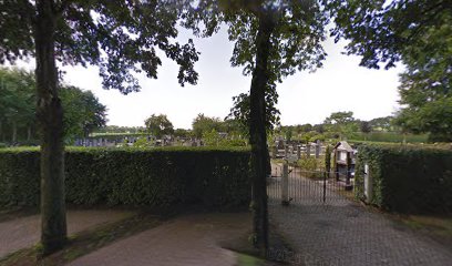
| Location | : | Veele, Vlagtwedde Municipality, Netherlands |
| Website | : | www.veelerkerkhof.nl/ |
| Coordinate | : | 53.0372680, 7.1001330 |
| Description | : | The first person was buried at this cemetery in 1876. Later, the cemetery was owned by the Trenning family. Eventually they family gave the cemetery to the people of Veele. |
frequently asked questions (FAQ):
-
Where is Begraafplaats Veelerkerkhof?
Begraafplaats Veelerkerkhof is located at Wedderstraat Veele, Vlagtwedde Municipality ,Groningen , 9541 EDNetherlands.
-
Begraafplaats Veelerkerkhof cemetery's updated grave count on graveviews.com?
0 memorials
-
Where are the coordinates of the Begraafplaats Veelerkerkhof?
Latitude: 53.0372680
Longitude: 7.1001330
Nearby Cemetories:
1. Vlagtwedde General Cemetery
Vlagtwedde, Vlagtwedde Municipality, Netherlands
Coordinate: 53.0252400, 7.1198700
2. Onstwedde General Cemetery
Onstwedde, Stadskanaal Municipality, Netherlands
Coordinate: 53.0425700, 7.0436300
3. Joodse Begraafplaats
Vlagtwedde Municipality, Netherlands
Coordinate: 53.0266000, 7.1584000
4. Vriescheloo Protestant Cemetery
Vriescheloo, Bellingwedde Municipality, Netherlands
Coordinate: 53.0762600, 7.1226700
5. Joodse Begraafplaats
Bourtange, Vlagtwedde Municipality, Netherlands
Coordinate: 53.0134700, 7.1837900
6. Blijham Protestant Cemetery
Blijham, Bellingwedde Municipality, Netherlands
Coordinate: 53.1106600, 7.0870100
7. Oude Pekela algemene begraafplaats
Oude Pekela, Pekela Municipality, Netherlands
Coordinate: 53.1016100, 7.0113100
8. Joodse Begraafplaats
Oude Pekela, Pekela Municipality, Netherlands
Coordinate: 53.1000000, 7.0072220
9. Nieuwe Pekela Luthers
Nieuwe Pekela, Pekela Municipality, Netherlands
Coordinate: 53.0882800, 6.9788500
10. Nieuwe Pekela Hervormd
Nieuwe Pekela, Pekela Municipality, Netherlands
Coordinate: 53.0741930, 6.9606250
11. Bellingwolde Begraafplaats Kerkweg
Bellingwolde, Bellingwedde Municipality, Netherlands
Coordinate: 53.1189500, 7.1705400
12. Joodse Begraafplaats
Bellingwolde, Bellingwedde Municipality, Netherlands
Coordinate: 53.1193400, 7.1700200
13. Boven Pekela cemetery
Boven Pekela, Pekela Municipality, Netherlands
Coordinate: 53.0342900, 6.9338300
14. Gemeentelijke Begraafplaats Ceresstraat
Stadskanaal, Stadskanaal Municipality, Netherlands
Coordinate: 52.9702635, 6.9754545
15. Begraafplaats Oosterkadekerk
Stadskanaal Municipality, Netherlands
Coordinate: 52.9776980, 6.9640720
16. Gemeentelijke Begraafplaats Brugstraat
Stadskanaal, Stadskanaal Municipality, Netherlands
Coordinate: 52.9774600, 6.9632400
17. Joodse Begraafplaats
Stadskanaal Municipality, Netherlands
Coordinate: 52.9686940, 6.9737780
18. Stadskanaal Noorderbegraafplaats
Stadskanaal, Stadskanaal Municipality, Netherlands
Coordinate: 53.0071900, 6.9182500
19. Floralaan
Musselkanaal, Stadskanaal Municipality, Netherlands
Coordinate: 52.9359046, 7.0092084
20. Oude Joodse Begraafplaats
Sint Vitusholt, Oldambt Municipality, Netherlands
Coordinate: 53.1437480, 7.0231610
21. Winschoten Oude Begraafplaats
Winschoten, Oldambt Municipality, Netherlands
Coordinate: 53.1450200, 7.0246400
22. Westerlee Churchyard
Westerlee, Oldambt Municipality, Netherlands
Coordinate: 53.1423510, 6.9815000
23. Joodse Begraafplaats
Ommelanderwijk, Veendam Municipality, Netherlands
Coordinate: 53.0822900, 6.9020500
24. Friedhof Wymeer
Bunde, Landkreis Leer, Germany
Coordinate: 53.1349470, 7.2400330