
| Memorials | : | 0 |
| Location | : | Willemstad, Moerdijk Municipality, Netherlands |
| Coordinate | : | 51.6958300, 4.4413000 |
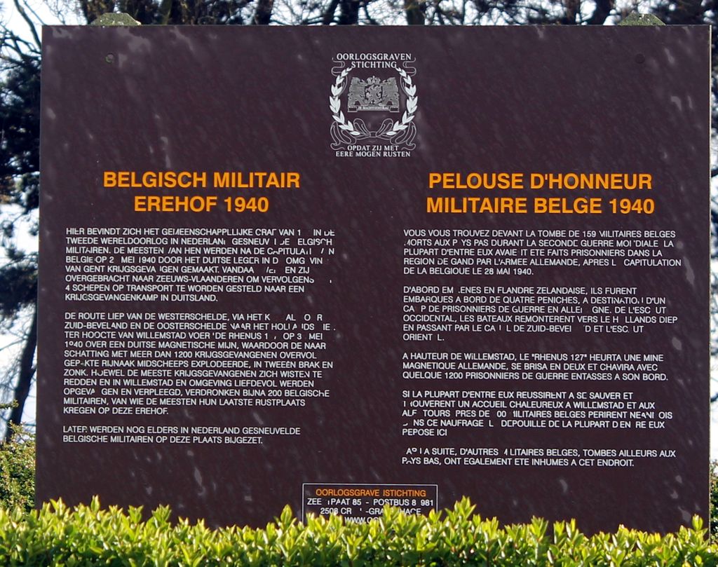
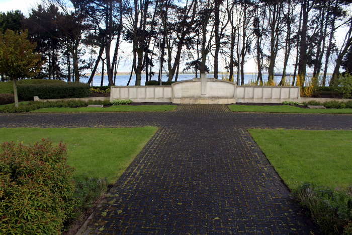
| Description | : | On the 30th of May 1940 the "Rhenus 127", packed with 1200 German prisoners of war, sailed over a German magnetic mine, on the 'Hollands Diep, near Willemstad. The ship broke in two and sank. Most of the prisoners managed to save themselves, but many Belgian soldiers drowned. (The estimates of the number who drowned vary from 132 to nearly 200.) The Belgian tribute cemetery in Willemstad (Moerdijk) contains the graves of 159 Belgian soldiers. There is a concrete memorial which is 1 meter high, 3 meter wide and 3 meter deep with the names of 159 Belgian... Read More |
frequently asked questions (FAQ):
-
Where is Belgian War Cemetery 1940?
Belgian War Cemetery 1940 is located at Willemstad, Moerdijk Municipality ,Noord-Brabant ,Netherlands.
-
Belgian War Cemetery 1940 cemetery's updated grave count on graveviews.com?
0 memorials
-
Where are the coordinates of the Belgian War Cemetery 1940?
Latitude: 51.6958300
Longitude: 4.4413000

Nearby Cemetories:
1. Koepelkerk Kerkhof
Willemstad, Moerdijk Municipality, Netherlands
Coordinate: 51.6921700, 4.4383000
2. Numansdorp Protestant Cemetery
Numansdorp, Cromstrijen Municipality, Netherlands
Coordinate: 51.7336800, 4.4298800
3. Fijnaart-en-Heiningen Roman Catholic Cemetery
Fijnaart, Moerdijk Municipality, Netherlands
Coordinate: 51.6368300, 4.4641900
4. Fijnaart-en-Heiningen Protestant Cemetery
Fijnaart, Moerdijk Municipality, Netherlands
Coordinate: 51.6376700, 4.4700100
5. Joodse Begraafplaats
Klundert, Moerdijk Municipality, Netherlands
Coordinate: 51.6645940, 4.5288210
6. Oude Begraafplaats
Zuid-Beijerland, Korendijk Municipality, Netherlands
Coordinate: 51.7490968, 4.3670754
7. Begraafplaats Noordhoek
Noordhoek, Moerdijk Municipality, Netherlands
Coordinate: 51.6419539, 4.5333775
8. Stampersgat Roman Catholic Cemetery
Stampersgat, Halderberge Municipality, Netherlands
Coordinate: 51.6141200, 4.4450400
9. Joodse Begraafplaats
Strijen Municipality, Netherlands
Coordinate: 51.7468300, 4.5570500
10. Standdaarbuiten Catholic Cemetery
Standdaarbuiten, Moerdijk Municipality, Netherlands
Coordinate: 51.6140900, 4.5149400
11. Begraafplaats Nederlands Hervormde Kerk v.m.
Standdaarbuiten, Moerdijk Municipality, Netherlands
Coordinate: 51.6089430, 4.5166929
12. Algemene Begraafplaats
Cillaarshoek, Strijen Municipality, Netherlands
Coordinate: 51.7721000, 4.5474300
13. Den Bommel General Cemetery
Den Bommel, Goeree-Overflakkee Municipality, Netherlands
Coordinate: 51.7159400, 4.2812700
14. Begraafplaats Noordtoren
Zevenbergen, Moerdijk Municipality, Netherlands
Coordinate: 51.6455214, 4.5835365
15. Algemene Begraafplaats
Mijnsheerenland, Binnenmaas Municipality, Netherlands
Coordinate: 51.7999720, 4.4823990
16. Algemene Begraafplaats
Zevenbergen, Moerdijk Municipality, Netherlands
Coordinate: 51.6465490, 4.5985048
17. R.K.Begraafplaats Laurentius
Oud Gastel, Halderberge Municipality, Netherlands
Coordinate: 51.5869694, 4.4628189
18. Rooms Katholieke Begraafplaats Zevenbergen
Zevenbergen, Moerdijk Municipality, Netherlands
Coordinate: 51.6454476, 4.5993329
19. Algemene Begraafplaats Oudenbosch
Oudenbosch, Halderberge Municipality, Netherlands
Coordinate: 51.5967744, 4.5244521
20. Protestantse Begraafplaats Moerdijk
Moerdijk, Moerdijk Municipality, Netherlands
Coordinate: 51.6999519, 4.6233284
21. Protestantse Begraafplaats
Oud Gastel, Halderberge Municipality, Netherlands
Coordinate: 51.5841651, 4.4683994
22. Rooms Katholieke Begraafplaats Moerdijk
Moerdijk, Moerdijk Municipality, Netherlands
Coordinate: 51.7012173, 4.6304095
23. Oudenbosch Rooms-Katholieke Begraafplaats
Oudenbosch, Halderberge Municipality, Netherlands
Coordinate: 51.5891200, 4.5310900
24. Piershil Algemene Begraafplaats
Piershil, Korendijk Municipality, Netherlands
Coordinate: 51.7936127, 4.3203654