
| Memorials | : | 0 |
| Location | : | Center Township, Benton County, USA |
| Coordinate | : | 40.5841904, -87.2491302 |
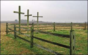
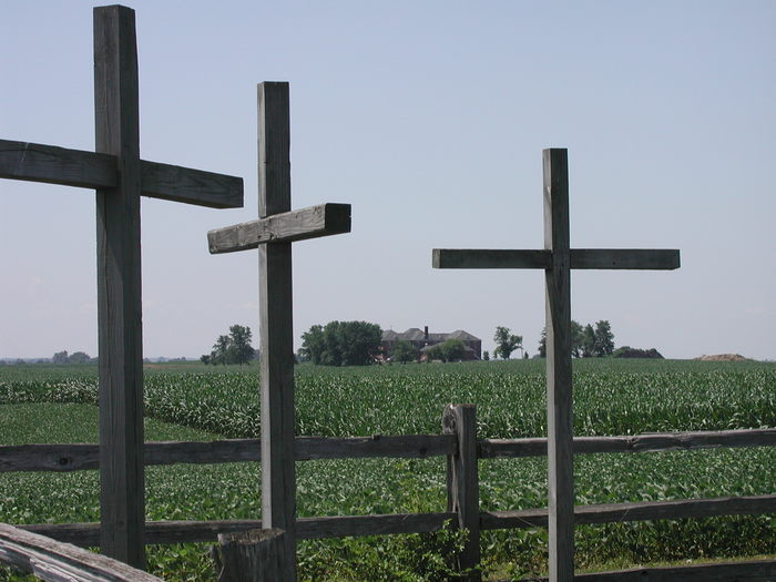
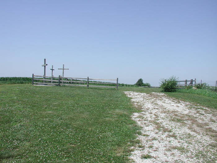
| Description | : | GPS Cords: 40.58419, -87.24913 Cemetery Notes: No stones at this cemetery. Until recently it was a cornfield, but once it was discovered - the Boy Scouts build the fence to protect it, and now 3 wooden crosses can be seen from the road. The cemetery is located in Center Township (SE quadrant of the SW quadrant of the SE quadrant of Section 30 Township 25N Range 7W) about 600 feet west of S County Road 400 E about 0.5 miles north of E County Road 200 S. Indiana Cemetery Locations, Volume 3, published by the... Read More |
frequently asked questions (FAQ):
-
Where is Benton County Poor Farm Cemetery?
Benton County Poor Farm Cemetery is located at S County Road 400 E Center Township, Benton County ,Indiana , 47944USA.
-
Benton County Poor Farm Cemetery cemetery's updated grave count on graveviews.com?
0 memorials
-
Where are the coordinates of the Benton County Poor Farm Cemetery?
Latitude: 40.5841904
Longitude: -87.2491302
Nearby Cemetories:
1. Davis Family Cemetery
Fowler, Benton County, USA
Coordinate: 40.5970060, -87.1691060
2. Dan Patch Gravesite
Oxford, Benton County, USA
Coordinate: 40.5194016, -87.2452011
3. Oxford West Cemetery
Oxford, Benton County, USA
Coordinate: 40.5188850, -87.2591260
4. Oxford Catholic Cemetery
Oxford, Benton County, USA
Coordinate: 40.5160751, -87.2466888
5. McConnell Cemetery
Oxford, Benton County, USA
Coordinate: 40.5157310, -87.2459150
6. Sacred Heart Cemetery
Fowler, Benton County, USA
Coordinate: 40.6075516, -87.3341980
7. Fowler Cemetery
Fowler, Benton County, USA
Coordinate: 40.6086731, -87.3342514
8. Justus Cemetery
Oxford, Benton County, USA
Coordinate: 40.5133018, -87.2489014
9. Timmons Cemetery
Oxford, Benton County, USA
Coordinate: 40.5630722, -87.1431503
10. Mount Gilboa Cemetery
Fowler, Benton County, USA
Coordinate: 40.6489983, -87.1664276
11. Griffin Cemetery
Templeton, Benton County, USA
Coordinate: 40.4991989, -87.2014008
12. Perigo Cemetery
Chase, Benton County, USA
Coordinate: 40.5094330, -87.3456730
13. Boswell Cemetery
Boswell, Benton County, USA
Coordinate: 40.5200005, -87.3700027
14. Robertson Cemetery (Defunct)
Dunnington, Benton County, USA
Coordinate: 40.6503270, -87.3810730
15. West Pine Chapel Cemetery
Pine Village, Warren County, USA
Coordinate: 40.4732500, -87.3297500
16. Smith Cemetery
Boswell, Benton County, USA
Coordinate: 40.4818993, -87.3589020
17. Pine Village Cemetery
Pine Village, Warren County, USA
Coordinate: 40.4486771, -87.2578812
18. Jones Cemetery
Hooker Corner, Warren County, USA
Coordinate: 40.4596620, -87.3210470
19. Hooker Cemetery
Rainsville, Warren County, USA
Coordinate: 40.4491997, -87.3161011
20. Gray Cemetery
Pine Village, Warren County, USA
Coordinate: 40.4413986, -87.2878036
21. Foster Cemetery
Green Hill, Warren County, USA
Coordinate: 40.4659400, -87.1259300
22. Apostolic Christian Church Cemetery
Fowler, Benton County, USA
Coordinate: 40.7075691, -87.1340637
23. Saint John the Baptist Cemetery
Earl Park, Benton County, USA
Coordinate: 40.6747017, -87.4222031
24. Earl Park Cemetery
Earl Park, Benton County, USA
Coordinate: 40.6755981, -87.4225006