
| Memorials | : | 103 |
| Location | : | Georgetown County, USA |
| Coordinate | : | 33.5476900, -79.3953610 |
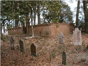
| Description | : | Black River Church or Prince Frederick's Church. This is the original location of the church before it was moved to Plantersville. There are two historical markers near the graveyard, Prince George Winyah Parish and Prince Frederick's Parish. The graveyard is on private property and borders the Black River. At least 3 individuals buried here are Revolutionary War Patriots. |
frequently asked questions (FAQ):
-
Where is Black River Church Cemetery?
Black River Church Cemetery is located at Hwy. 51 (Browns Ferry) near Dunbar, S.C. Georgetown County ,South Carolina ,USA.
-
Black River Church Cemetery cemetery's updated grave count on graveviews.com?
103 memorials
-
Where are the coordinates of the Black River Church Cemetery?
Latitude: 33.5476900
Longitude: -79.3953610
Nearby Cemetories:
1. Wilson Cemetery
Georgetown County, USA
Coordinate: 33.5513992, -79.4024963
2. Old Prince Frederick Cemetery
Georgetown County, USA
Coordinate: 33.5350120, -79.3909680
3. Eastland Cemetery
Georgetown, Georgetown County, USA
Coordinate: 33.5314400, -79.3864600
4. Exum Family Cemetery
Choppee, Georgetown County, USA
Coordinate: 33.5660000, -79.3814370
5. Antioch Cemetery
Rhems, Georgetown County, USA
Coordinate: 33.5674700, -79.4204000
6. Rocky Point Plantation Cemetery
Choppee, Georgetown County, USA
Coordinate: 33.5480120, -79.3560500
7. Mount Olive Missionary Baptist Church Cemetery
Georgetown, Georgetown County, USA
Coordinate: 33.5275410, -79.3540620
8. Barnes Cemetery
Andrews, Williamsburg County, USA
Coordinate: 33.5716960, -79.4381910
9. Rose Hill Cemetery
Georgetown, Georgetown County, USA
Coordinate: 33.5927880, -79.4013580
10. Moore Family Graveyard
Rose Hill, Georgetown County, USA
Coordinate: 33.5925200, -79.4176370
11. Baxley Family Cemetery
Choppee, Georgetown County, USA
Coordinate: 33.5619860, -79.3391890
12. Arnett Memorial Gardens
Georgetown County, USA
Coordinate: 33.5532830, -79.3320450
13. Nazareth AME Church
Georgetown, Georgetown County, USA
Coordinate: 33.5439480, -79.3289290
14. Mount Sinai Baptist Church Cemetery
Georgetown, Georgetown County, USA
Coordinate: 33.4982000, -79.3619800
15. Red Hill Cemetery
Georgetown County, USA
Coordinate: 33.5958360, -79.4425890
16. Chester Hill Missionary Baptist Cemetery
Georgetown, Georgetown County, USA
Coordinate: 33.4881950, -79.3680360
17. Hopewell Missionary Church Cemetery
Georgetown, Georgetown County, USA
Coordinate: 33.5329160, -79.3183170
18. Johnson Family Cemetery
Georgetown County, USA
Coordinate: 33.4855760, -79.3630240
19. Saint Paul AME Cemetery
Oatland, Georgetown County, USA
Coordinate: 33.4882000, -79.3486800
20. Saint Lukes AME Church Cemetery
Georgetown County, USA
Coordinate: 33.6213913, -79.4112015
21. Central Missionary Baptist Church
Williamsburg County, USA
Coordinate: 33.5901100, -79.3175900
22. Greater Mount Ararat Cemetery
Nesmith, Williamsburg County, USA
Coordinate: 33.6142200, -79.4524700
23. Black Mingo Jack's Creek Millpond Graveyard
Nesmith, Williamsburg County, USA
Coordinate: 33.6205300, -79.4456000
24. Black Mingo Cemetery
Williamsburg County, USA
Coordinate: 33.6194000, -79.4480972