
| Memorials | : | 0 |
| Location | : | Powiat kędzierzyńsko-kozielski, Poland |
| Coordinate | : | 50.3584050, 18.3221940 |
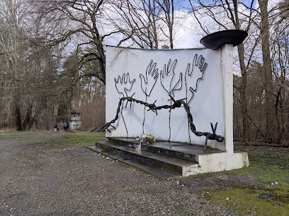
| Description | : | Second-largest subcamp of Auschwitz concentration camp. Established on 1 April 1944; initially with 3,000 male and 200 female prisoners. Housed approximately 4,500 prisoners from fifteen countries at its peak. The SS evacuated the camp on 21 January 1945 due to the approach of the Red Army; about 4,000 prisoners were marched to Gross-Rosen concentration camp, arriving on 2 February. |
frequently asked questions (FAQ):
-
Where is Blechhammer Concentration Camp?
Blechhammer Concentration Camp is located at Blachownia Śląska Powiat kędzierzyńsko-kozielski ,Opolskie ,Poland.
-
Blechhammer Concentration Camp cemetery's updated grave count on graveviews.com?
0 memorials
-
Where are the coordinates of the Blechhammer Concentration Camp?
Latitude: 50.3584050
Longitude: 18.3221940
Nearby Cemetories:
1. Sławięcice Communal Cemetery
Opole, Miasto Opole, Poland
Coordinate: 50.3815500, 18.3126471
2. Ujazd Old Communal Cemetery
Opole, Miasto Opole, Poland
Coordinate: 50.3883296, 18.3589507
3. Cmentarz Komunalny Kuźniczka
Powiat kędzierzyńsko-kozielski, Poland
Coordinate: 50.3561008, 18.1982702
4. Klucz Catholic Cemetery
Opole, Miasto Opole, Poland
Coordinate: 50.4356519, 18.2828430
5. Klodnica Communcal Cemetery
Opole, Miasto Opole, Poland
Coordinate: 50.3519210, 18.1694476
6. Cmentarz Koźle
Powiat kędzierzyńsko-kozielski, Poland
Coordinate: 50.3224707, 18.1534550
7. Koźle Old Communal Cemetery
Opole, Miasto Opole, Poland
Coordinate: 50.3276687, 18.1509425
8. Leśnica Communal Cemetery
Opole, Miasto Opole, Poland
Coordinate: 50.4340219, 18.1891626
9. Góra Świętej Anny Cemetery
Opole, Miasto Opole, Poland
Coordinate: 50.4559500, 18.1709800
10. Church. St. Nicholas
Żyrowa, Powiat krapkowicki, Poland
Coordinate: 50.4534520, 18.1314970
11. Strzelce Opolskie Communal Cemetery
Opole, Miasto Opole, Poland
Coordinate: 50.5129401, 18.2910418
12. Szymiszów Church of St. Simon and St. Jude
Powiat strzelecki, Poland
Coordinate: 50.5174036, 18.2518617
13. Pokrzywnica Catholic Cemetery
Opole, Miasto Opole, Poland
Coordinate: 50.3373829, 18.0604687
14. Łany Catholic Cemetery
Opole, Miasto Opole, Poland
Coordinate: 50.2116166, 18.1887323
15. Lenschütz Cemetery
Powiat kędzierzyńsko-kozielski, Poland
Coordinate: 50.2913730, 18.0655230
16. Jemielnica Church of All Saints
Opole, Miasto Opole, Poland
Coordinate: 50.5451996, 18.3867174
17. Sakrau Labor Camp
Powiat krapkowicki, Poland
Coordinate: 50.4811110, 18.0852780
18. Pawłowiczki Church of St. Andrew and St. Jame
Opole, Miasto Opole, Poland
Coordinate: 50.2518430, 18.0558694
19. Pawłowiczki Catholic Cemetery
Opole, Miasto Opole, Poland
Coordinate: 50.2510991, 18.0562102
20. Friedhof Twardawa
Opole, Miasto Opole, Poland
Coordinate: 50.3419170, 17.9942680
21. Kirche Twardawa
Opole, Miasto Opole, Poland
Coordinate: 50.3442510, 17.9876280
22. Gogolin Parish Cemetery
Opole, Miasto Opole, Poland
Coordinate: 50.4900735, 18.0304671
23. St. Brixen Bryksy
Powiat kędzierzyńsko-kozielski, Poland
Coordinate: 50.2894680, 17.9742540
24. Kamień Śląski Church of St. Hyacint
Opole, Miasto Opole, Poland
Coordinate: 50.5394114, 18.0754378