
| Memorials | : | 8 |
| Location | : | Höör, Höörs kommun, Sweden |
| Coordinate | : | 55.8772220, 13.5186110 |
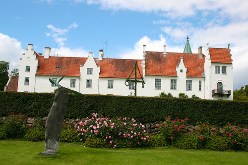
| Description | : | Bosjökloster Castle or Bosjö Abbey, on the shore of Lake Ringsjön in Höör Municipality, Scania, southern Sweden was originally a nunnery, founded in 1080 by the Benedictine Order. The oldest preserved document that mentions Bosjö Abbey was written by Pope Lucius III in 1181, when he confirmed its privileges. According to local legend, the land was donated by Tord Thott, the first known ancestor of the Scanian noble family Thott. The abbey was transformed into a castle in the 16th century, and only parts of the original building remains. No one knows exactly when Bosjökloster was founded, but most of those... Read More |
frequently asked questions (FAQ):
-
Where is Bosjökloster?
Bosjökloster is located at Bosjökloster 111 S-243 95 Höör Höör, Höörs kommun ,Skåne län ,Sweden.
-
Bosjökloster cemetery's updated grave count on graveviews.com?
0 memorials
-
Where are the coordinates of the Bosjökloster?
Latitude: 55.8772220
Longitude: 13.5186110
Nearby Cemetories:
1. Stehags Kyrkogård
Stehag, Eslövs kommun, Sweden
Coordinate: 55.8972610, 13.4154224
2. Gudmuntorp Kyrkogard
Gudmuntorp, Höörs kommun, Sweden
Coordinate: 55.8175370, 13.4832510
3. Eslöv Cemetery
Eslöv, Eslövs kommun, Sweden
Coordinate: 55.8292000, 13.2993850
4. Norra Rörum Kyrkogård
Norra Rorum, Höörs kommun, Sweden
Coordinate: 56.0202914, 13.5120413
5. Västra Sallerup kyrkogården
Eslöv, Eslövs kommun, Sweden
Coordinate: 55.8296490, 13.2744130
6. Holmby Kyrkogard
Holmby, Eslövs kommun, Sweden
Coordinate: 55.7475170, 13.4025110
7. Långaröds kyrkogård
Hörby kommun, Sweden
Coordinate: 55.7877780, 13.8380560
8. Öveds Kyrkogård
Vollsjo, Sjöbo kommun, Sweden
Coordinate: 55.6886928, 13.6440773
9. Konga Cemetery
Konga, Svalövs kommun, Sweden
Coordinate: 55.9786757, 13.1997595
10. Torrlösa Kyrkogård
Torrlösa, Svalövs kommun, Sweden
Coordinate: 55.9102400, 13.1424700
11. Stora Harrie
Stora Harrie, Kävlinge kommun, Sweden
Coordinate: 55.8078680, 13.1548061
12. Riseberga Churchyard
Riseberga, Klippans kommun, Sweden
Coordinate: 56.0724417, 13.3017722
13. Vollsjö Lutheran Church Cemetery
Vollsjo, Sjöbo kommun, Sweden
Coordinate: 55.6939190, 13.7756540
14. Dalby Kyrka
Lunds kommun, Sweden
Coordinate: 55.6643304, 13.3442858
15. Fredentorp Cemetery
Lund, Lunds kommun, Sweden
Coordinate: 55.7306750, 13.1781860
16. Veberöds kyrkogård
Veberod, Lunds kommun, Sweden
Coordinate: 55.6345795, 13.4893709
17. Södervidinge Kyrkogård
Sodervidinge, Kävlinge kommun, Sweden
Coordinate: 55.8218690, 13.0959845
18. Lund Northern Cemetery
Lund, Lunds kommun, Sweden
Coordinate: 55.7145400, 13.1926900
19. Lunds Östra kyrkogård
Lund, Lunds kommun, Sweden
Coordinate: 55.6990000, 13.2016000
20. Stora Råby kyrkogård
Lunds kommun, Sweden
Coordinate: 55.6859377, 13.2250434
21. Sankt Lars
Lund, Lunds kommun, Sweden
Coordinate: 55.6817900, 13.1676700
22. Esarp
Staffanstorps kommun, Sweden
Coordinate: 55.6188889, 13.3261111
23. Uppåkra Kyrkogård
Lilla Uppakra, Staffanstorps kommun, Sweden
Coordinate: 55.6610140, 13.1855162
24. Lyngby Cemetery
Lyngby, Lunds kommun, Sweden
Coordinate: 55.5967500, 13.3422100