
| Memorials | : | 0 |
| Location | : | Norra Rorum, Höörs kommun, Sweden |
| Phone | : | 0413-220 95 |
| Website | : | www.svenskakyrkan.se/hoor/norra-rorums-kyrka |
| Coordinate | : | 56.0202914, 13.5120413 |
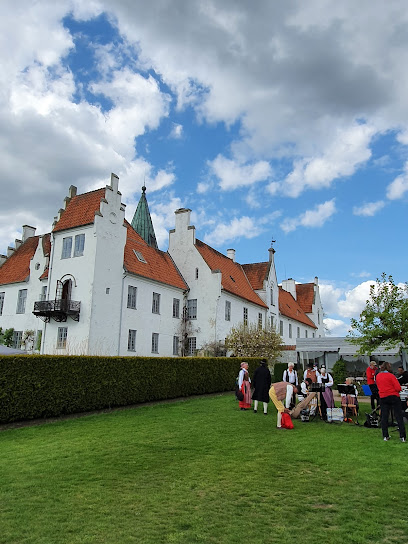
| Description | : | Norra Rörum's church is a Roman medieval church, originally built around the year 1200. In 1782 a large "new church" was added to the south. At about the same time, a burial ground was built in the middle of the north of the Lillienberg and Stiernclou estuaries. The upper floor of the tomb was open inward to the church and served as a so-called dominion church (now sacristy). About 1830 the entire church was placed under thin vaults, and the altar was moved from the choir in the east to its present location in the middle of the northern wall.... Read More |
frequently asked questions (FAQ):
-
Where is Norra Rörum Kyrkogård?
Norra Rörum Kyrkogård is located at Hammarsväg 1, 243 92 Höör Norra Rorum, Höörs kommun ,Skåne län ,Sweden.
-
Norra Rörum Kyrkogård cemetery's updated grave count on graveviews.com?
0 memorials
-
Where are the coordinates of the Norra Rörum Kyrkogård?
Latitude: 56.0202914
Longitude: 13.5120413
Nearby Cemetories:
1. Riseberga Churchyard
Riseberga, Klippans kommun, Sweden
Coordinate: 56.0724417, 13.3017722
2. Stehags Kyrkogård
Stehag, Eslövs kommun, Sweden
Coordinate: 55.8972610, 13.4154224
3. Bosjökloster
Höör, Höörs kommun, Sweden
Coordinate: 55.8772220, 13.5186110
4. Konga Cemetery
Konga, Svalövs kommun, Sweden
Coordinate: 55.9786757, 13.1997595
5. East Cemetery
Hassleholm, Hässleholms kommun, Sweden
Coordinate: 56.1541940, 13.7787090
6. Gudmuntorp Kyrkogard
Gudmuntorp, Höörs kommun, Sweden
Coordinate: 55.8175370, 13.4832510
7. Eslöv Cemetery
Eslöv, Eslövs kommun, Sweden
Coordinate: 55.8292000, 13.2993850
8. Klippans Kapellkyrkogård
Klippan, Klippans kommun, Sweden
Coordinate: 56.1352600, 13.1556600
9. Västra Sallerup kyrkogården
Eslöv, Eslövs kommun, Sweden
Coordinate: 55.8296490, 13.2744130
10. Torrlösa Kyrkogård
Torrlösa, Svalövs kommun, Sweden
Coordinate: 55.9102400, 13.1424700
11. Vinslöv Kyrkogårdar
Vinslov, Hässleholms kommun, Sweden
Coordinate: 56.1073330, 13.9155520
12. Holmby Kyrkogard
Holmby, Eslövs kommun, Sweden
Coordinate: 55.7475170, 13.4025110
13. Nya Kyrkogården
Örkelljunga kommun, Sweden
Coordinate: 56.2788143, 13.2711418
14. Stora Harrie
Stora Harrie, Kävlinge kommun, Sweden
Coordinate: 55.8078680, 13.1548061
15. Långaröds kyrkogård
Hörby kommun, Sweden
Coordinate: 55.7877780, 13.8380560
16. Sireköpinge Kyrka
Landskrona kommun, Sweden
Coordinate: 55.9277780, 12.9922220
17. Södervidinge Kyrkogård
Sodervidinge, Kävlinge kommun, Sweden
Coordinate: 55.8218690, 13.0959845
18. Bjornekulla Kyrka
Åstorp, Åstorps kommun, Sweden
Coordinate: 56.1340861, 12.9631889
19. Öveds Kyrkogård
Vollsjo, Sjöbo kommun, Sweden
Coordinate: 55.6886928, 13.6440773
20. Össjö Kyrkogård
Ängelholm, Ängelholms kommun, Sweden
Coordinate: 56.2287780, 13.0280280
21. Fredentorp Cemetery
Lund, Lunds kommun, Sweden
Coordinate: 55.7306750, 13.1781860
22. Gryts Kyrkogård
Gryt, Östra Göinge kommun, Sweden
Coordinate: 56.2056600, 14.0491300
23. Lund Northern Cemetery
Lund, Lunds kommun, Sweden
Coordinate: 55.7145400, 13.1926900
24. Saxtorp Kyrkogård
Saxtorp, Landskrona kommun, Sweden
Coordinate: 55.8400034, 12.9597311