
| Memorials | : | 0 |
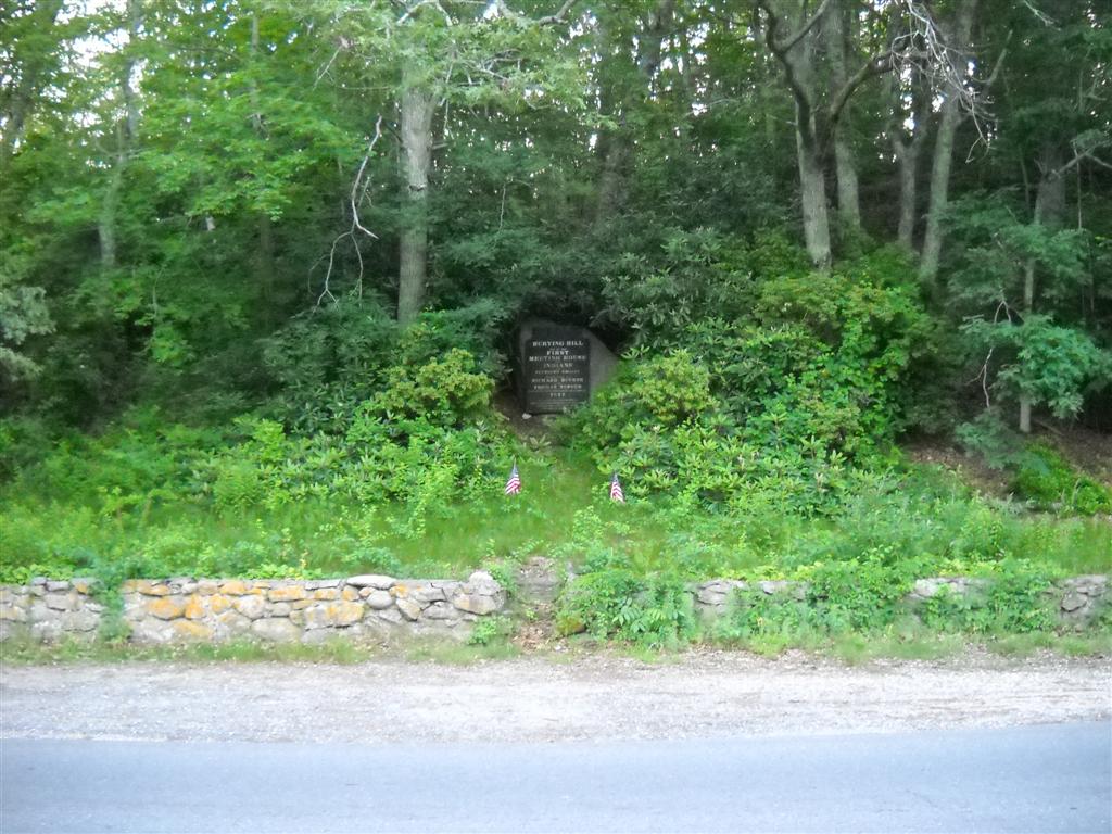
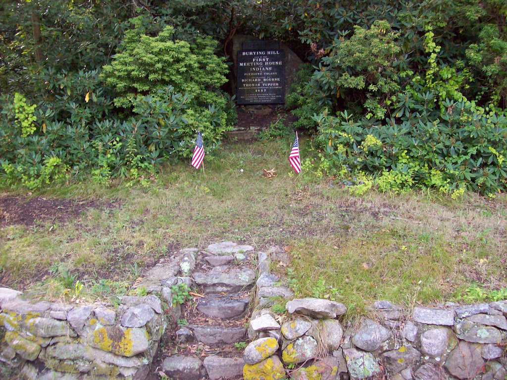
| Location | : | Bourne, Barnstable County, USA |
| Coordinate | : | 41.7741520, -70.5611730 |
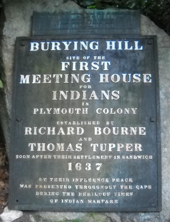
| Description | : | The plaque reads: BURYING HILL Site of the FIRST MEETING HOUSE for INDIANS in Plymouth Colony Established by RICHARD BOURNE and THOMAS TUPPER soon after their settlement in Sandwich 1637 By their influence peace was preserved throughout the Cape during the perilous times of Indian warfare. |
frequently asked questions (FAQ):
-
Where is Bournedale Burying Hill?
Bournedale Burying Hill is located at Bourne, Barnstable County ,Massachusetts ,USA.
-
Bournedale Burying Hill cemetery's updated grave count on graveviews.com?
0 memorials
-
Where are the coordinates of the Bournedale Burying Hill?
Latitude: 41.7741520
Longitude: -70.5611730
Nearby Cemetories:
1. Bournedale Herring Pond Indian Cemetery
Bourne, Barnstable County, USA
Coordinate: 41.7861900, -70.5658722
2. Herring Pond Wampanoag Indian Cemetery
Plymouth, Plymouth County, USA
Coordinate: 41.7867290, -70.5658940
3. Sagamore Cemetery
Bourne, Barnstable County, USA
Coordinate: 41.7714005, -70.5339966
4. Herring Pond Cemetery
Plymouth, Plymouth County, USA
Coordinate: 41.7971700, -70.5588800
5. Cedarville Cemetery
Plymouth, Plymouth County, USA
Coordinate: 41.8049736, -70.5560837
6. Saddle and Pillion Cemetery
Sagamore, Barnstable County, USA
Coordinate: 41.7672005, -70.5192032
7. Bourne Family Cemetery #02
Bourne, Barnstable County, USA
Coordinate: 41.7577230, -70.6001190
8. Nightingale Cemetery
Plymouth, Plymouth County, USA
Coordinate: 41.8113400, -70.5588260
9. Bourne Family Cemetery
Bourne, Barnstable County, USA
Coordinate: 41.7501602, -70.6032104
10. Bourne Village Cemetery
Bourne, Barnstable County, USA
Coordinate: 41.7425117, -70.5938110
11. Lakewood Cemetery
Plymouth, Plymouth County, USA
Coordinate: 41.8141260, -70.5567690
12. Bay View Cemetery
Sandwich, Barnstable County, USA
Coordinate: 41.7583008, -70.5102997
13. Freeman Cemetery
Sandwich, Barnstable County, USA
Coordinate: 41.7573013, -70.5083008
14. Old Bourne Cemetery
Bourne, Barnstable County, USA
Coordinate: 41.7386017, -70.5986023
15. Saint Peters Cemetery
Sandwich, Barnstable County, USA
Coordinate: 41.7502480, -70.5079346
16. Oakland Grove Cemetery
Bourne, Barnstable County, USA
Coordinate: 41.7402992, -70.6042023
17. Old Town Cemetery
Sandwich, Barnstable County, USA
Coordinate: 41.7556992, -70.5011978
18. Nickerson Burial Ground
Plymouth, Plymouth County, USA
Coordinate: 41.7642740, -70.6306530
19. Monument Neck Cemetery
Gray Gables, Barnstable County, USA
Coordinate: 41.7346001, -70.6128006
20. Mount Hope Cemetery
Sandwich, Barnstable County, USA
Coordinate: 41.7518997, -70.4850006
21. Almshouse Burial Ground
Sandwich, Barnstable County, USA
Coordinate: 41.7501000, -70.4847000
22. Long Neck Cemetery
Wareham, Plymouth County, USA
Coordinate: 41.7461014, -70.6369019
23. Spring Hill Cemetery
Sandwich, Barnstable County, USA
Coordinate: 41.7487984, -70.4775009
24. Monument Beach Cemetery
Monument Beach, Barnstable County, USA
Coordinate: 41.7151800, -70.6094600