
| Memorials | : | 0 |
| Location | : | Tallapoosa County, USA |
| Coordinate | : | 32.6851145, -85.8688873 |
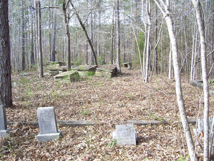
| Description | : | SE 1/4 SE 1/4 Section 29 Township 20N Range 22E. This cemetery is located 1.3 miles southwest of Union Methodist Church on Alabama Highway 50; 75 feet south of the road. There are 9 or 10 stacked rock tombs with no identification and one 10 X 12 foot stacked rock tomb. About 20 -25 graves have no identification. This cemetery is in only fair condition and seems to receive very little upkeep. No burials have taken place here for 50 - 60 years. Recorded by R McNutt on February 16, 1995. |
frequently asked questions (FAQ):
-
Where is Boyd Cemetery?
Boyd Cemetery is located at Tallapoosa County ,Alabama ,USA.
-
Boyd Cemetery cemetery's updated grave count on graveviews.com?
0 memorials
-
Where are the coordinates of the Boyd Cemetery?
Latitude: 32.6851145
Longitude: -85.8688873
Nearby Cemetories:
1. Guthrie Cemetery
Tallapoosa County, USA
Coordinate: 32.6636009, -85.8703003
2. Beulah Cemetery
Tallapoosa County, USA
Coordinate: 32.6618996, -85.8561020
3. Harper Hill Cemetery
Tallapoosa County, USA
Coordinate: 32.6706009, -85.8380966
4. New Prospect United Methodist Church Cemetery
Reeltown, Tallapoosa County, USA
Coordinate: 32.6769040, -85.8195900
5. Centerport Cemetery
Tallapoosa County, USA
Coordinate: 32.7272606, -85.8528137
6. Hornsby Cemetery on Goldmine Road
Kent, Elmore County, USA
Coordinate: 32.6568100, -85.9119980
7. Lovejoy Cemetery
Elmore County, USA
Coordinate: 32.7033005, -85.9400024
8. Hornsby Cemetery at Red Hill
Tallassee, Elmore County, USA
Coordinate: 32.6854040, -85.9434510
9. Refuge Cemetery
Red Hill, Elmore County, USA
Coordinate: 32.6842995, -85.9439011
10. County Line Cemetery
Kowaliga, Elmore County, USA
Coordinate: 32.7425995, -85.9175491
11. Taunton Cemetery
Red Hill, Elmore County, USA
Coordinate: 32.6511830, -85.9426330
12. Old Doris Chapel Cemetery
Tallassee, Elmore County, USA
Coordinate: 32.6228290, -85.9129280
13. Hornsby Cemetery
Elmore County, USA
Coordinate: 32.6231003, -85.9139023
14. Sharon Cemetery
Reeltown, Tallapoosa County, USA
Coordinate: 32.6166800, -85.8349900
15. Saugahatchee Assembly of God Cemetery
Reeltown, Tallapoosa County, USA
Coordinate: 32.6419470, -85.7964310
16. Old Sharon Primitive Baptist Cemetery
Reeltown, Tallapoosa County, USA
Coordinate: 32.6411600, -85.7965300
17. Pleasant Valley Missionary Baptist Church Cemetery
Tallapoosa County, USA
Coordinate: 32.6736840, -85.7752450
18. Pleasant Hill Church Cemetery
Kent, Elmore County, USA
Coordinate: 32.6308330, -85.9431000
19. Shiloh Missionary Baptist Church Cemetery
Kowaliga, Elmore County, USA
Coordinate: 32.7175800, -85.9680800
20. Bethlehem East Cemetery
Kent, Elmore County, USA
Coordinate: 32.6199989, -85.9430008
21. Watson Chapel Cemetery
Red Hill, Elmore County, USA
Coordinate: 32.6819000, -85.9760971
22. Benson-Bethel United Methodist Church Cemetery
Kowaliga, Elmore County, USA
Coordinate: 32.7165900, -85.9714500
23. Sardis United Methodist Church Cemetery
Thornton, Tallapoosa County, USA
Coordinate: 32.7043991, -85.7589035
24. Lake Martin Baptist Church
Dadeville, Tallapoosa County, USA
Coordinate: 32.7675700, -85.8118100