
| Memorials | : | 0 |
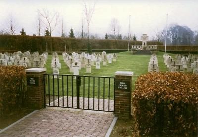
| Location | : | Breda, Breda Municipality, Netherlands |
| Coordinate | : | 51.5826900, 4.7472600 |
frequently asked questions (FAQ):
-
Where is Breda Polish Military Cemetery?
Breda Polish Military Cemetery is located at Breda, Breda Municipality ,Noord-Brabant ,Netherlands.
-
Breda Polish Military Cemetery cemetery's updated grave count on graveviews.com?
0 memorials
-
Where are the coordinates of the Breda Polish Military Cemetery?
Latitude: 51.5826900
Longitude: 4.7472600


Nearby Cemetories:
1. Breda Begraafplaats Haagveld
Breda, Breda Municipality, Netherlands
Coordinate: 51.5791800, 4.7469830
2. Breda Zuylen Roman Catholic Cemetery
Breda, Breda Municipality, Netherlands
Coordinate: 51.5793400, 4.7489700
3. Princenhage Cemetery
Princenhage, Breda Municipality, Netherlands
Coordinate: 51.5762400, 4.7392600
4. Markendaalse Kerk Cemetery
Breda, Breda Municipality, Netherlands
Coordinate: 51.5887628, 4.7710466
5. Breda Grote Kerk
Breda, Breda Municipality, Netherlands
Coordinate: 51.5890000, 4.7750000
6. Our Lady's Church
Breda, Breda Municipality, Netherlands
Coordinate: 51.5890900, 4.7753160
7. Begraafplaats Prinsenbeek
Prinsenbeek, Breda Municipality, Netherlands
Coordinate: 51.6004268, 4.7167543
8. Begraafplaats RK Kerk Heilige Moeder Gods
Effen, Breda Municipality, Netherlands
Coordinate: 51.5541678, 4.7332827
9. Breda Begraafplaats Vogelenzang
Breda, Breda Municipality, Netherlands
Coordinate: 51.5687100, 4.7912500
10. Breda De Bieberg Begraafplaats
Breda, Breda Municipality, Netherlands
Coordinate: 51.5576400, 4.7885300
11. Breda Begraafplaats Overakker
Breda, Breda Municipality, Netherlands
Coordinate: 51.5671900, 4.8036700
12. Ulvenhout Roman Catholic Cemetery
Ulvenhout, Breda Municipality, Netherlands
Coordinate: 51.5525900, 4.7961100
13. Begraafplaats Teteringen
Teteringen, Breda Municipality, Netherlands
Coordinate: 51.6112929, 4.8165026
14. Bavel Katholieke Begraafplaats
Bavel, Breda Municipality, Netherlands
Coordinate: 51.5659700, 4.8294800
15. Terheijden Antonius Abt Kerkhof
Terheijden, Drimmelen Municipality, Netherlands
Coordinate: 51.6425700, 4.7518400
16. Etten-Leur Cemetery
Etten-Leur Municipality, Netherlands
Coordinate: 51.5603076, 4.6457993
17. Begraafplaats St Marcoen
Dorst, Oosterhout Municipality, Netherlands
Coordinate: 51.5906301, 4.8581754
18. Joodse Begraafplaats
Oosterhout, Oosterhout Municipality, Netherlands
Coordinate: 51.6396000, 4.8201600
19. Roman Catholic Cemetery Sint Bavo Parish
Zundert Municipality, Netherlands
Coordinate: 51.5142580, 4.7002220
20. Begraafplaats Parochie H Gummarus
Wagenberg, Drimmelen Municipality, Netherlands
Coordinate: 51.6646339, 4.7468280
21. Kerkhof Langeweg
Langeweg, Moerdijk Municipality, Netherlands
Coordinate: 51.6467982, 4.6645953
22. Oosterhout Protestant Cemetery
Oosterhout, Oosterhout Municipality, Netherlands
Coordinate: 51.6415100, 4.8510800
23. R.K. Begraafplaats Heilige Cornelius
Den Hout, Oosterhout Municipality, Netherlands
Coordinate: 51.6600504, 4.8136076
24. Made General Cemetery
Made, Drimmelen Municipality, Netherlands
Coordinate: 51.6709734, 4.7794867