
| Memorials | : | 45 |
| Location | : | Upper Marlboro, Prince George's County, USA |
| Coordinate | : | 38.6971300, -76.7357800 |
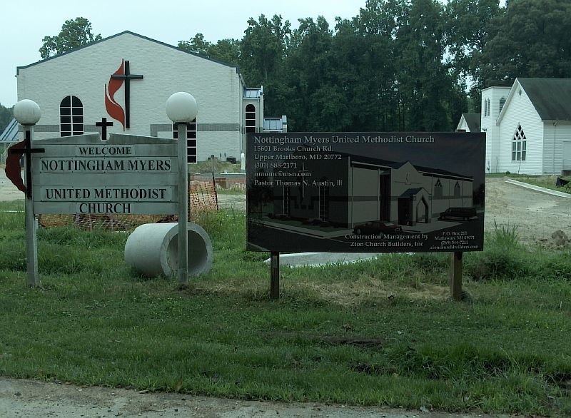
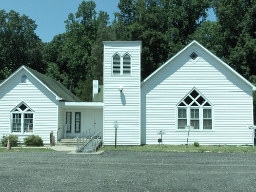
| Description | : | 15601 Brooks Church Road Upper Marlboro, MD 20772 (Upper Marlboro zip code, it's located in Naylor, Maryland) (301) 888-2171 This black church began in 1867 when John H. Skimmer, who was a prominent planter in the Nottingham area, sold one acre of land of his farm "Mansfield" to five black trustees for the sole purpose of establishing a Methodist church and school for black children. A small log church was built in 1879 and was named Brooks Church. The original log church was destroyed in 1939 for the construction of a new Italinate style church. The church was renamed in 1955. It's... Read More |
frequently asked questions (FAQ):
-
Where is Brooks Myers United Methodist Church Cemetery?
Brooks Myers United Methodist Church Cemetery is located at 15601 Brooks Church Road Upper Marlboro, Prince George's County ,Maryland ,USA.
-
Brooks Myers United Methodist Church Cemetery cemetery's updated grave count on graveviews.com?
45 memorials
-
Where are the coordinates of the Brooks Myers United Methodist Church Cemetery?
Latitude: 38.6971300
Longitude: -76.7357800
Nearby Cemetories:
1. Waring Hollyday Family Cemetery
Baden, Prince George's County, USA
Coordinate: 38.6877365, -76.7495270
2. Brookfield United Methodist Church Cemetery
Naylor, Prince George's County, USA
Coordinate: 38.7126800, -76.7454700
3. Skinner Family Cemetery
Naylor, Prince George's County, USA
Coordinate: 38.7122879, -76.7477112
4. Naylor Family Cemetery
Brandywine, Prince George's County, USA
Coordinate: 38.6680500, -76.7327600
5. Bowie Family Cemetery
Croom, Prince George's County, USA
Coordinate: 38.7365500, -76.7447500
6. Mackall Family Cemetery
Brandywine, Prince George's County, USA
Coordinate: 38.7129200, -76.7832200
7. Saint Pauls Episcopal Cemetery
Baden, Prince George's County, USA
Coordinate: 38.6605988, -76.7724991
8. Saint Simons Episcopal Chapel Cemetery
Prince George's County, USA
Coordinate: 38.7442017, -76.7544022
9. Immanuel United Methodist Church Cemetery
Brandywine, Prince George's County, USA
Coordinate: 38.6516991, -76.7716980
10. Saint Thomas Episcopal Church Cemetery
Croom, Prince George's County, USA
Coordinate: 38.7477989, -76.7585983
11. Gibbons Church Cemetery
Brandywine, Prince George's County, USA
Coordinate: 38.6961000, -76.8090000
12. Sim Grave Cemetery
Croom, Prince George's County, USA
Coordinate: 38.7455200, -76.7777700
13. Smithville Methodist Church Cemetery
Dunkirk, Calvert County, USA
Coordinate: 38.7216000, -76.6668400
14. Sadigstone Grave
Aquasco, Prince George's County, USA
Coordinate: 38.7435532, -76.7839890
15. Shiloh Methodist Episcopal Church South
Dunkirk, Calvert County, USA
Coordinate: 38.7207630, -76.6612240
16. Hampton Plantation
Owings, Calvert County, USA
Coordinate: 38.6851220, -76.6560340
17. Cedarville Assembly of God Church Cemetery
Brandywine, Prince George's County, USA
Coordinate: 38.6631012, -76.8047028
18. House of Prayer Cemetery
Brandywine, Prince George's County, USA
Coordinate: 38.6962600, -76.8180300
19. Saint Mary's Methodist Episcopal Cemetery
Croom, Prince George's County, USA
Coordinate: 38.7600470, -76.7580380
20. Fowler Tanyhill Family Cemetery
Dunkirk, Calvert County, USA
Coordinate: 38.7151300, -76.6549100
21. Orme Family Cemetery
Orme, Prince George's County, USA
Coordinate: 38.6319427, -76.7497253
22. Coopers United Methodist Church Cemetery
Dunkirk, Calvert County, USA
Coordinate: 38.7070500, -76.6498800
23. Southern Memorial Gardens
Dunkirk, Calvert County, USA
Coordinate: 38.7200012, -76.6532974
24. Connick Family Cemetery
Baden, Prince George's County, USA
Coordinate: 38.6285900, -76.7516500