
| Memorials | : | 1 |
| Location | : | Palestine, Anderson County, USA |
| Coordinate | : | 31.7632160, -95.7189850 |
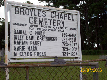
| Description | : | 31degree 45' 48"N, Lon: 95degree 43' 08"W A granite stone at the entrance to the cemetery says that C.J. (Charlie) and Mary (Molly) Poole donated the Broyles Chapel Cemetery land on April 16, 1904. Broyles Chapel Cemetery is located on the north side of Farm Road 320 (Sterne Avenue) west of Palestine, Texas, several miles outside the city limits. It is well kept and surrounded by a chain link fence. |
frequently asked questions (FAQ):
-
Where is Broyles Chapel Cemetery?
Broyles Chapel Cemetery is located at Palestine, Anderson County ,Texas ,USA.
-
Broyles Chapel Cemetery cemetery's updated grave count on graveviews.com?
1 memorials
-
Where are the coordinates of the Broyles Chapel Cemetery?
Latitude: 31.7632160
Longitude: -95.7189850
Nearby Cemetories:
1. Rocky Point Cemetery
Palestine, Anderson County, USA
Coordinate: 31.7932400, -95.7100030
2. Land of Memory Cemetery
Palestine, Anderson County, USA
Coordinate: 31.7975700, -95.7115200
3. McMeans Cemetery
Anderson County, USA
Coordinate: 31.7608662, -95.6684265
4. Crist-Calloway Cemetery
Harmony, Anderson County, USA
Coordinate: 31.7188570, -95.7583390
5. Link Family Cemetery
Palestine, Anderson County, USA
Coordinate: 31.8209520, -95.7081150
6. Fort Houston Cemetery
Palestine, Anderson County, USA
Coordinate: 31.7271996, -95.6519012
7. Mount Zion Cemetery
Palestine, Anderson County, USA
Coordinate: 31.7408400, -95.7949100
8. Newton Cemetery
Palestine, Anderson County, USA
Coordinate: 31.8033790, -95.6506470
9. Halick Cemetery
Palestine, Anderson County, USA
Coordinate: 31.7015170, -95.6767560
10. Mallard Cemetery
Palestine, Anderson County, USA
Coordinate: 31.8125070, -95.6415700
11. Beth Israel Cemetery
Palestine, Anderson County, USA
Coordinate: 31.7722600, -95.6217400
12. Syrian Cemetery
Palestine, Anderson County, USA
Coordinate: 31.7731090, -95.6212350
13. Saint Josephs Catholic Cemetery
Palestine, Anderson County, USA
Coordinate: 31.7724600, -95.6210550
14. Palestine City Cemetery
Palestine, Anderson County, USA
Coordinate: 31.7638600, -95.6176400
15. Pleasant Springs Cemetery
Palestine, Anderson County, USA
Coordinate: 31.7250004, -95.6256027
16. Memorial Cemetery
Palestine, Anderson County, USA
Coordinate: 31.7722206, -95.6149673
17. Bacon Cemetery #01
Anderson County, USA
Coordinate: 31.6613998, -95.7303009
18. Price Cemetery
Anderson County, USA
Coordinate: 31.8038029, -95.6085053
19. Jerusalem & Bethel Cemetery
Montalba, Anderson County, USA
Coordinate: 31.8622208, -95.6885071
20. Magnolia Cemetery
Tucker, Anderson County, USA
Coordinate: 31.6588993, -95.7375031
21. Antioch Cemetery
Montalba, Anderson County, USA
Coordinate: 31.8717500, -95.7049500
22. Butler Family Cemetery
Montalba, Anderson County, USA
Coordinate: 31.8647920, -95.6718300
23. Roselawn Park Cemetery
Palestine, Anderson County, USA
Coordinate: 31.7537510, -95.5862480
24. Hubbard Cemetery
Palestine, Anderson County, USA
Coordinate: 31.7002850, -95.6020850