
| Memorials | : | 1 |
| Location | : | Holderness, Grafton County, USA |
| Coordinate | : | 43.7583600, -71.5675200 |
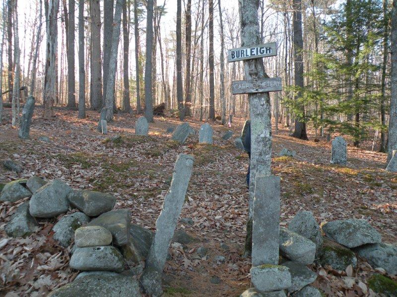
| Description | : | This cemetery is very old and small, few stones still standing but hard to read. Some stones on ground and broken. There are many field stones which are apparently headstones. NO CARR stones found. To get to cemetery take RT 113 in Holderness, go left onto Burleigh farm road, follow to farm, then take another left at the farm on to a dirt road which is also Burleigh farm road. Grave yard is on the right hand side on the hill up the dirt road. |
frequently asked questions (FAQ):
-
Where is Burleigh-Carr Cemetery?
Burleigh-Carr Cemetery is located at Holderness, Grafton County ,New Hampshire ,USA.
-
Burleigh-Carr Cemetery cemetery's updated grave count on graveviews.com?
1 memorials
-
Where are the coordinates of the Burleigh-Carr Cemetery?
Latitude: 43.7583600
Longitude: -71.5675200
Nearby Cemetories:
1. Prescott Cemetery
Holderness, Grafton County, USA
Coordinate: 43.7546400, -71.5682400
2. True Cemetery
Holderness, Grafton County, USA
Coordinate: 43.7819440, -71.5538890
3. Sanborn Cemetery
Holderness, Grafton County, USA
Coordinate: 43.7612800, -71.6050600
4. Squam Bridge Cemetery
Holderness, Grafton County, USA
Coordinate: 43.7316500, -71.5887200
5. Ladd Cemetery
Holderness, Grafton County, USA
Coordinate: 43.7873700, -71.5506400
6. George Cemetery
Sandwich, Carroll County, USA
Coordinate: 43.7880560, -71.5338890
7. Shaw Cemetery
Holderness, Grafton County, USA
Coordinate: 43.7436110, -71.6225000
8. Piper Cemetery
Holderness, Grafton County, USA
Coordinate: 43.7133460, -71.5691080
9. Eastman Cemetery
Sandwich, Carroll County, USA
Coordinate: 43.7930300, -71.5263500
10. Owl Brook Cemetery
Ashland, Grafton County, USA
Coordinate: 43.7333200, -71.6300100
11. Campbell Cemetery
Center Harbor, Belknap County, USA
Coordinate: 43.7372686, -71.5012926
12. Clark Cemetery
Ashland, Grafton County, USA
Coordinate: 43.7133330, -71.6113890
13. Howe-Clark Cemetery
Grafton County, USA
Coordinate: 43.7133330, -71.6113890
14. Hicks Hill Cemetery
Ashland, Grafton County, USA
Coordinate: 43.7277780, -71.6313890
15. East Holderness Cemetery
Holderness, Grafton County, USA
Coordinate: 43.7112700, -71.5257800
16. Eastman Cemetery
Holderness, Grafton County, USA
Coordinate: 43.7013890, -71.5522220
17. Coxboro Cemetery
Holderness, Grafton County, USA
Coordinate: 43.6979600, -71.5640000
18. Church Hill Cemetery
Ashland, Grafton County, USA
Coordinate: 43.7455560, -71.6522220
19. Thompson Cemetery
Sandwich, Carroll County, USA
Coordinate: 43.8014000, -71.5025000
20. Merrill Cemetery
Holderness, Grafton County, USA
Coordinate: 43.6933330, -71.5677780
21. Eastern Corner Road Cemetery
Campton, Grafton County, USA
Coordinate: 43.8177540, -71.6045920
22. Greenleaf Cemetery
Center Harbor, Belknap County, USA
Coordinate: 43.6930560, -71.5436110
23. Fogg Cemetery
New Hampton, Belknap County, USA
Coordinate: 43.6908330, -71.5827780
24. Thompson Cemetery
Center Harbor, Belknap County, USA
Coordinate: 43.7036070, -71.5099560