| Memorials | : | 99 |
| Location | : | Cania, North Burnett Region, Australia |
| Coordinate | : | -24.6524500, 150.9827500 |
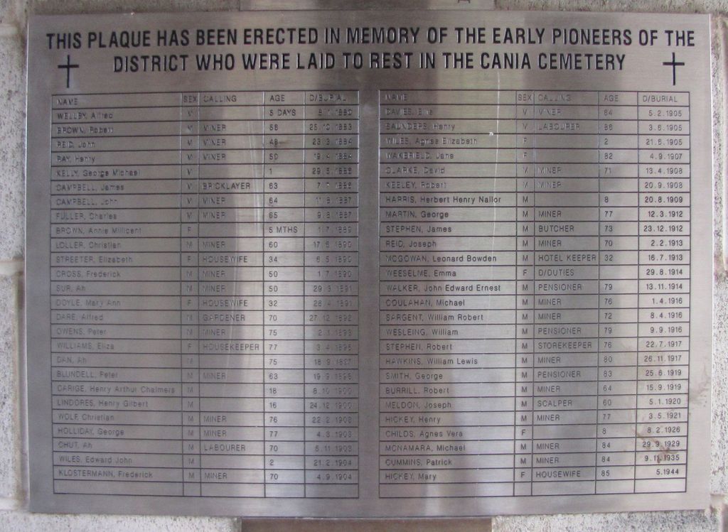
| Description | : | Cania Cemetery was the cemetery for a small gold mining community. It is now located under the waters impounded by Cania Dam (Lake Cania), located on 3 Moon Creek, a tributary of the Burnett River. A memorial for the cemetery and those interred is located near the dam wall. Recorded burials are dated from 1880 to 1944. The GPS/map is that of the memorial and relocated headstones, not of the actual cemetery. |
frequently asked questions (FAQ):
-
Where is Cania Cemetery?
Cania Cemetery is located at Cania, North Burnett Region ,Queensland ,Australia.
-
Cania Cemetery cemetery's updated grave count on graveviews.com?
99 memorials
-
Where are the coordinates of the Cania Cemetery?
Latitude: -24.6524500
Longitude: 150.9827500
Nearby Cemetories:
1. Monto Cemetery
Monto, North Burnett Region, Australia
Coordinate: -24.8481228, 151.1401369
2. Mulgildie Cemetery
Mulgildie, North Burnett Region, Australia
Coordinate: -24.9688690, 151.1355900
3. Builyan Cemetery
Builyan, Gladstone Region, Australia
Coordinate: -24.5294091, 151.3854020
4. Rawbelle Cemetery and Homestead
Rawbelle, North Burnett Region, Australia
Coordinate: -25.0303900, 150.8394100
5. Biloela Lawn Cemetery
Biloela, Banana Shire, Australia
Coordinate: -24.4151320, 150.5343680
6. Biloela Monumental Cemetery
Biloela, Banana Shire, Australia
Coordinate: -24.3949580, 150.5203020
7. Edan Park Cemetery
Biloela, Banana Shire, Australia
Coordinate: -24.3928519, 150.5214024
8. Miriam Vale Pioneer Cemetery
Miriam Vale, Gladstone Region, Australia
Coordinate: -24.3226660, 151.5537650
9. Bororen Cemetery
Bororen, Gladstone Region, Australia
Coordinate: -24.2552740, 151.4997310
10. Calliope Cemetery
Calliope, Gladstone Region, Australia
Coordinate: -24.0102060, 151.2094060
11. Calliope Lawn Cemetery
Calliope, Gladstone Region, Australia
Coordinate: -24.0097200, 151.2093200
12. Binjour Cemetery
Binjour, North Burnett Region, Australia
Coordinate: -25.3074300, 151.2626200
13. Jambin Cemetery
Jambin, Banana Shire, Australia
Coordinate: -24.1653890, 150.3713830
14. Eidsvold Cemetery
Eidsvold, North Burnett Region, Australia
Coordinate: -25.3948440, 151.1182060
15. Boyne Tannum Memorial Parklands
Boyne Island, Gladstone Region, Australia
Coordinate: -23.9721533, 151.3390476
16. Boolboonda Cemetery
Boolboonda, Bundaberg Region, Australia
Coordinate: -25.0652000, 151.6921200
17. Lone Grave Boyne Island
Boyne Island, Gladstone Region, Australia
Coordinate: -23.9370940, 151.3426570
18. Banana Cemetery
Banana, Banana Shire, Australia
Coordinate: -24.4667020, 150.1226700
19. Mount Perry Cemetery
Mount Perry, North Burnett Region, Australia
Coordinate: -25.1844540, 151.6523560
20. Port Curtis Garden Cemetery
Gladstone, Gladstone Region, Australia
Coordinate: -23.8687930, 151.2122510
21. Gladstone Cemetery
Gladstone, Gladstone Region, Australia
Coordinate: -23.8670550, 151.2392600
22. Friend Park
Gladstone, Gladstone Region, Australia
Coordinate: -23.8498400, 151.2744000
23. Mount Larcom General Cemetery
Mount Larcom, Gladstone Region, Australia
Coordinate: -23.8067677, 150.9823696
24. Rosedale Cemetery
Rosedale, Gladstone Region, Australia
Coordinate: -24.6180630, 151.9158230

