| Memorials | : | 1 |
| Location | : | Carmantown, Atlantic County, USA |
| Coordinate | : | 39.4483250, -74.6446000 |
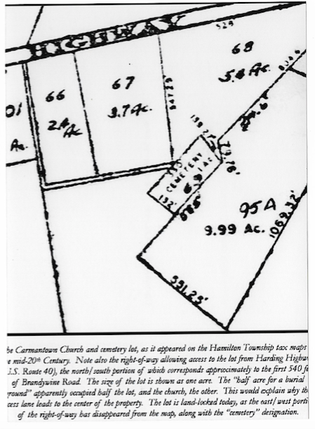
| Description | : | The Carmantown Church and cemetery lot, as it appeared on the Hamilton Township tax maps in the mid-20th Century. Note also the right-of-way allowing access to the lot from Harding Highway (U.S. Route 40), the north/south portion of which corresponds approximately to the first 540 feet of Brandywine Road. The size of the lot is shown as one acre. The "half acre for a burial ground" apparently occupied half the lot, and the church, the other. This would explain why the access lane leads to the center of the property. The lot is land-locked today,... Read More |
frequently asked questions (FAQ):
-
Where is Carmantown Cemetery?
Carmantown Cemetery is located at Yorktown Place Carmantown, Atlantic County ,New Jersey , 08330USA.
-
Carmantown Cemetery cemetery's updated grave count on graveviews.com?
1 memorials
-
Where are the coordinates of the Carmantown Cemetery?
Latitude: 39.4483250
Longitude: -74.6446000
Nearby Cemetories:
1. Holy Cross Cemetery and Chapel Mausoleum
Mays Landing, Atlantic County, USA
Coordinate: 39.4490395, -74.6839523
2. Lincoln Memorial Park
Mays Landing, Atlantic County, USA
Coordinate: 39.4478493, -74.6872635
3. Laurel Memorial Park and Crematory
Egg Harbor Township, Atlantic County, USA
Coordinate: 39.4565887, -74.5941925
4. Union Cemetery
Mays Landing, Atlantic County, USA
Coordinate: 39.4373894, -74.7080536
5. Presbyterian Cemetery
Mays Landing, Atlantic County, USA
Coordinate: 39.4539185, -74.7269821
6. Westcott Free Burying Ground
Mays Landing, Atlantic County, USA
Coordinate: 39.4526215, -74.7281189
7. Catawba Church and Burying Ground
Atlantic County, USA
Coordinate: 39.4082794, -74.7136078
8. Beth Kehillah Cemetery
Egg Harbor Township, Atlantic County, USA
Coordinate: 39.4091250, -74.5689580
9. Rodef Sholom Cemetery
Egg Harbor Township, Atlantic County, USA
Coordinate: 39.4080000, -74.5670500
10. Emeth Shalom Cemetery
Egg Harbor Township, Atlantic County, USA
Coordinate: 39.4067154, -74.5674896
11. Smith-Ireland Burying Ground
Estellville, Atlantic County, USA
Coordinate: 39.4151800, -74.7329640
12. Saint Nicholas Roman Catholic Church Cemetery
Egg Harbor City, Atlantic County, USA
Coordinate: 39.5318222, -74.6367950
13. Ahavas Abram Cemetery
Egg Harbor Township, Atlantic County, USA
Coordinate: 39.3990135, -74.5517273
14. Beth Israel Cemetery
Egg Harbor Township, Atlantic County, USA
Coordinate: 39.3980500, -74.5524300
15. Beth Jacob Cemetery
Egg Harbor Township, Atlantic County, USA
Coordinate: 39.3980500, -74.5524300
16. Mount Calvary Cemetery
Pleasantville, Atlantic County, USA
Coordinate: 39.3983002, -74.5511017
17. Asbury Methodist Episcopal Church Cemetery
English Creek, Atlantic County, USA
Coordinate: 39.3621483, -74.6706314
18. Zion United Methodist Church Cemetery
Egg Harbor Township, Atlantic County, USA
Coordinate: 39.3674200, -74.5880000
19. Zion Cemetery
Bargaintown, Atlantic County, USA
Coordinate: 39.3661390, -74.5885100
20. Germania Cemetery
Germania, Atlantic County, USA
Coordinate: 39.5310707, -74.5867081
21. Atlantic County Veterans Cemetery
Estell Manor, Atlantic County, USA
Coordinate: 39.3882790, -74.7386017
22. Estellville Methodist Church Cemetery
Mays Landing, Atlantic County, USA
Coordinate: 39.3976900, -74.7477700
23. Methodist Burying Ground
Estellville, Atlantic County, USA
Coordinate: 39.3978615, -74.7480164
24. Steelmans Creek Burial Ground
Estell Manor, Atlantic County, USA
Coordinate: 39.3878517, -74.7388687

