
| Memorials | : | 0 |
| Location | : | Monroeville, Monroe County, USA |
| Coordinate | : | 31.5816700, -87.4297200 |
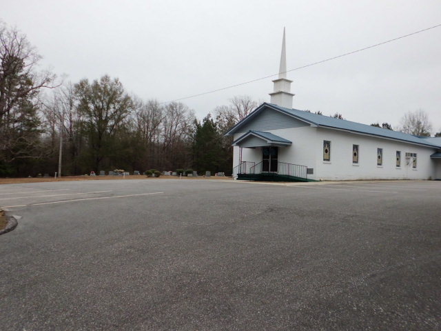
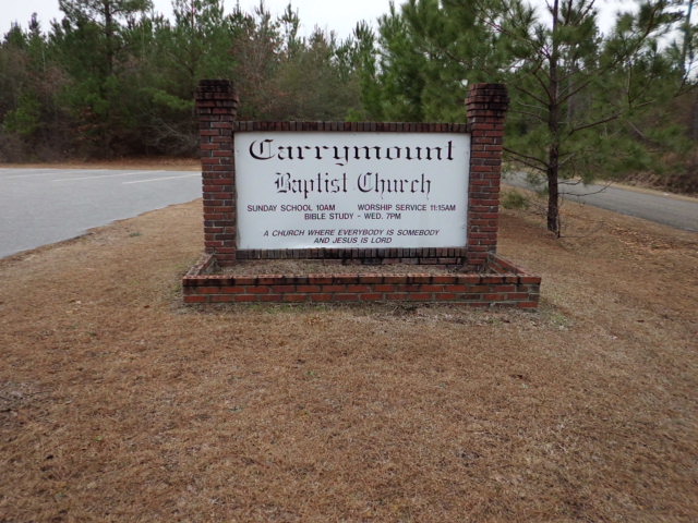
| Description | : | The church/cemetery is southeast of the community of Fountain, Monroeville postal zone. From Monroeville take Highway 41 north. Turn left (west) at Hixon Road (also known as Snyder Quarters Road) through Fountain. Cross the rail lines and the cemetery is 1.6 miles on the left side of the road. Another direct route is to follow Hwy-84 from Monroeville through Purdue Hill. At the Lena Landeeger Highway turn right and follow to Fountain and its intersection with Hwy-41. Turn right onto Hwy-41, go under the RR trestle and up a long hill, turn right onto Hixon Road... Read More |
frequently asked questions (FAQ):
-
Where is Carrymount Baptist Church Cemetery?
Carrymount Baptist Church Cemetery is located at 22 Snyder Quarters Rd Monroeville, Monroe County ,Alabama ,USA.
-
Carrymount Baptist Church Cemetery cemetery's updated grave count on graveviews.com?
0 memorials
-
Where are the coordinates of the Carrymount Baptist Church Cemetery?
Latitude: 31.5816700
Longitude: -87.4297200
Nearby Cemetories:
1. Fountain Baptist Cemetery
Fountain, Monroe County, USA
Coordinate: 31.5956760, -87.4063830
2. Crapps Cemetery
Old Salem, Monroe County, USA
Coordinate: 31.5411040, -87.4381380
3. Old Salem Cemetery
Old Salem, Monroe County, USA
Coordinate: 31.5410260, -87.4094710
4. New Chapel Cemetery
Mexia, Monroe County, USA
Coordinate: 31.5413850, -87.4039490
5. Bryant Cemetery
Finchburg, Monroe County, USA
Coordinate: 31.6275005, -87.4480972
6. Palmer Abney Cemetery
Monroe County, USA
Coordinate: 31.5925680, -87.3740500
7. York Chapel AME Church Cemetery
Finchburg, Monroe County, USA
Coordinate: 31.6305510, -87.4264434
8. Saint Thomas Church Cemetery
Wainwright, Monroe County, USA
Coordinate: 31.6127110, -87.4849650
9. Ridge Cemetery #2
Monroe County, USA
Coordinate: 31.5944970, -87.3636620
10. Eureka Baptist Church Cemetery
Finchburg, Monroe County, USA
Coordinate: 31.6356130, -87.4657830
11. Forehand Cemetery
Wainwright, Monroe County, USA
Coordinate: 31.6316060, -87.4775220
12. Mount Ararat Cemetery
Monroe County, USA
Coordinate: 31.6449300, -87.4054900
13. Williams-English Cemetery
Finchburg, Monroe County, USA
Coordinate: 31.6131880, -87.4987010
14. Holmes Cemetery
Finchburg, Monroe County, USA
Coordinate: 31.6089320, -87.5036450
15. Lowery Family Cemetery
Perdue Hill, Monroe County, USA
Coordinate: 31.5208333, -87.3911111
16. Bryant-Deer Cemetery
Monroe County, USA
Coordinate: 31.6488991, -87.4013977
17. Corinth-Deer Cemetery
Franklin, Monroe County, USA
Coordinate: 31.6491670, -87.4012540
18. Ridge Cemetery
Peterman, Monroe County, USA
Coordinate: 31.5967007, -87.3471985
19. Racom Cemetery
Perdue Hill, Monroe County, USA
Coordinate: 31.5101230, -87.4470280
20. Bohannon Smith Cemetery
Mexia, Monroe County, USA
Coordinate: 31.5234440, -87.3761940
21. Frye Cemetery
Axle, Monroe County, USA
Coordinate: 31.6180120, -87.3507500
22. Claiborne Cemetery
Monroe County, USA
Coordinate: 31.5464001, -87.5124969
23. Bethel Baptist Church Cemetery
Monroeville, Monroe County, USA
Coordinate: 31.5367190, -87.3527030
24. Dellet Family Cemetery
Claiborne, Monroe County, USA
Coordinate: 31.5480213, -87.5146866