
| Memorials | : | 0 |
| Location | : | Monroe County, USA |
| Coordinate | : | 31.5944970, -87.3636620 |
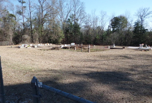
| Description | : | The Ridge Cemetery (also known as Lower Ridge Cemetery)is easily confused with the Ridge Cemetery, which is located a couple miles east on the same county road, but on the north side, in a wooded area. To reach this cemetery requires one to drive through the historic town of Monroeville, Alabama. At the NW corner of the old courthouse square turn right onto Hwy-41, north toward the Claiborne Lock & Dam area. Leaving Monroeville, drive about 5 miles to where CR-42 will "T" into Hwy-41. Turn right onto CR-42 and go past the new Antioch Church... Read More |
frequently asked questions (FAQ):
-
Where is Ridge Cemetery #2?
Ridge Cemetery #2 is located at CR-42 West Monroe County ,Alabama , 36460USA.
-
Ridge Cemetery #2 cemetery's updated grave count on graveviews.com?
0 memorials
-
Where are the coordinates of the Ridge Cemetery #2?
Latitude: 31.5944970
Longitude: -87.3636620

Nearby Cemetories:
1. Palmer Abney Cemetery
Monroe County, USA
Coordinate: 31.5925680, -87.3740500
2. Ridge Cemetery
Peterman, Monroe County, USA
Coordinate: 31.5967007, -87.3471985
3. Frye Cemetery
Axle, Monroe County, USA
Coordinate: 31.6180120, -87.3507500
4. McWilliams-Davison Cemetery
Axle, Monroe County, USA
Coordinate: 31.5956440, -87.3279620
5. Fountain Baptist Cemetery
Fountain, Monroe County, USA
Coordinate: 31.5956760, -87.4063830
6. Limestone Missionary Baptist Church Cemetery
Monroe County, USA
Coordinate: 31.5503900, -87.3322200
7. Carrymount Baptist Church Cemetery
Monroeville, Monroe County, USA
Coordinate: 31.5816700, -87.4297200
8. Bethel Baptist Church Cemetery
Monroeville, Monroe County, USA
Coordinate: 31.5367190, -87.3527030
9. Mount Ararat Cemetery
Monroe County, USA
Coordinate: 31.6449300, -87.4054900
10. Mount Olive Baptist Church Cemetery
Monroe County, USA
Coordinate: 31.6145950, -87.2941930
11. Bryant-Deer Cemetery
Monroe County, USA
Coordinate: 31.6488991, -87.4013977
12. New Chapel Cemetery
Mexia, Monroe County, USA
Coordinate: 31.5413850, -87.4039490
13. Corinth-Deer Cemetery
Franklin, Monroe County, USA
Coordinate: 31.6491670, -87.4012540
14. York Chapel AME Church Cemetery
Finchburg, Monroe County, USA
Coordinate: 31.6305510, -87.4264434
15. Old Salem Cemetery
Old Salem, Monroe County, USA
Coordinate: 31.5410260, -87.4094710
16. Mars Hill Baptist Church Cemetery
Peterman, Monroe County, USA
Coordinate: 31.5942320, -87.2849240
17. Hopewell C.M.E. Church Cemetery
Monroeville, Monroe County, USA
Coordinate: 31.5258700, -87.3407600
18. Bohannon Smith Cemetery
Mexia, Monroe County, USA
Coordinate: 31.5234440, -87.3761940
19. Methodist Cemetery
Monroeville, Monroe County, USA
Coordinate: 31.5272630, -87.3294760
20. Virginia Tucker Memorial Chapel Cemetery
Monroeville, Monroe County, USA
Coordinate: 31.5277805, -87.3247223
21. Pineville Cemetery
Monroeville, Monroe County, USA
Coordinate: 31.5302930, -87.3187190
22. Baptist Cemetery
Monroeville, Monroe County, USA
Coordinate: 31.5300700, -87.3187100
23. Hillcrest Cemetery
Monroeville, Monroe County, USA
Coordinate: 31.5300370, -87.3175070
24. Lowery Family Cemetery
Perdue Hill, Monroe County, USA
Coordinate: 31.5208333, -87.3911111