
| Memorials | : | 0 |
| Location | : | Gilmer County, USA |
| Coordinate | : | 34.6505090, -84.3885000 |
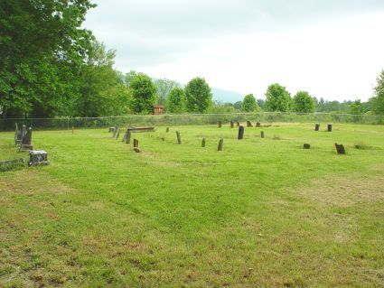
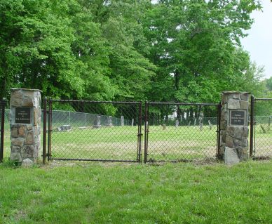
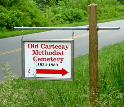
| Description | : | Directions: From Ellijay or Hwy 515, take Hwy 52 East for approx. seven miles to intersection with Roy Road. Turn left onto Roy Road. This old cemetery is on the left about one-half mile down Roy Road -- look for the sign on the left. The land for a church and cemetery was granted to Cartecay Methodist Church in 1844 by Lewis D. Ellington. After that church was destroyed by fire, a new church was built in 1859 at what is now the intersection of Hwy 52 East and Roy Roy, on land donated to the church by Barnett... Read More |
frequently asked questions (FAQ):
-
Where is Cartecay United Methodist Church Cemetery Old?
Cartecay United Methodist Church Cemetery Old is located at Roy Road Gilmer County ,Georgia ,USA.
-
Cartecay United Methodist Church Cemetery Old cemetery's updated grave count on graveviews.com?
0 memorials
-
Where are the coordinates of the Cartecay United Methodist Church Cemetery Old?
Latitude: 34.6505090
Longitude: -84.3885000
Nearby Cemetories:
1. Cartecay United Methodist Church Cemetery
Cartecay, Gilmer County, USA
Coordinate: 34.6444016, -84.3893967
2. Pettit Family Cemetery
Ellijay, Gilmer County, USA
Coordinate: 34.6609450, -84.3878120
3. Flint Hill Cemetery
Ellijay, Gilmer County, USA
Coordinate: 34.6619730, -84.3775210
4. Mount Zion Baptist Church Cemetery
Ellijay, Gilmer County, USA
Coordinate: 34.6642000, -84.4146000
5. Scrougetown Baptist Church Cemetery
Gilmer County, USA
Coordinate: 34.6739006, -84.3743973
6. River Hill Baptist Church Cemetery
Ellijay, Gilmer County, USA
Coordinate: 34.6653700, -84.3574580
7. Oak Hill United Methodist Church Cemetery
Gilmer County, USA
Coordinate: 34.6537940, -84.4381450
8. Ebenezer Baptist Church Cemetery
Ellijay, Gilmer County, USA
Coordinate: 34.6147194, -84.3619385
9. Edmundson Family Cemetery
Tickanetley, Gilmer County, USA
Coordinate: 34.6626510, -84.3396740
10. Faith Chapel Church of God of Prophecy Cemetery
Ellijay, Gilmer County, USA
Coordinate: 34.6742830, -84.3439350
11. Burrell Cemetery
Ellijay, Gilmer County, USA
Coordinate: 34.6172220, -84.3488880
12. Teague Family Cemetery
Ellijay, Gilmer County, USA
Coordinate: 34.6214840, -84.4355940
13. New Testament Church Cemetery
Ellijay, Gilmer County, USA
Coordinate: 34.6795500, -84.3296900
14. Macedonia Baptist Church Cemetery
Ellijay, Gilmer County, USA
Coordinate: 34.6768400, -84.3274800
15. Clear Creek Baptist Church Cemetery
Gilmer County, USA
Coordinate: 34.5992012, -84.4199982
16. Old Cloninger Cemetery
Gilmer County, USA
Coordinate: 34.6197900, -84.4528500
17. New Liberty Baptist Church Cemetery
Ellijay, Gilmer County, USA
Coordinate: 34.6801338, -84.3178024
18. Turniptown Baptist Church Cemetery
East Ellijay, Gilmer County, USA
Coordinate: 34.7103004, -84.4218979
19. Davis Cemetery
Ellijay, Gilmer County, USA
Coordinate: 34.6482720, -84.4686990
20. Bible Baptist Church Cemetery
Ellijay, Gilmer County, USA
Coordinate: 34.6421180, -84.4702590
21. Yukon Cemetery
Ellijay, Gilmer County, USA
Coordinate: 34.6243970, -84.4652080
22. Ellijay Church of Christ Cemetery
Ellijay, Gilmer County, USA
Coordinate: 34.6236100, -84.4652700
23. East New Hope Baptist Church Cemetery
Roy, Gilmer County, USA
Coordinate: 34.6632410, -84.3062840
24. Mount Vernon Baptist Church Cemetery
Ellijay, Gilmer County, USA
Coordinate: 34.6249710, -84.4663560