
| Memorials | : | 0 |
| Location | : | Kent, Marshall County, USA |
| Coordinate | : | 39.7614450, -80.8641560 |
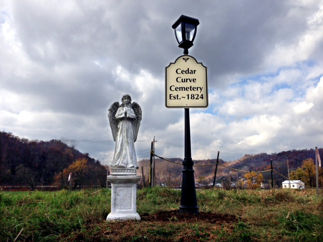
| Description | : | Employees of the Dominion Natrium Processing Facility, in partnership with Blue Racer Midstream, have undertaken the commendable civic duty of restoring two very old Marshall County cemeteries that lie within the secure borders of the Fractionation Facility. Through an archeological survey of their lands, Dominion determined the location of the abandoned Locust Grove and Cedar Curve Cemeteries. These burial grounds lie near the railroad line adjacent to the Ohio River in a section of Franklin District formerly known variously as Wells Bottom and Welcome. Locust Grove has 32 grave markers including one veteran of the Revolutionary War, while Cedar Curve... Read More |
frequently asked questions (FAQ):
-
Where is Cedar Curve Cemetery?
Cedar Curve Cemetery is located at Kent, Marshall County ,West Virginia , 26055USA.
-
Cedar Curve Cemetery cemetery's updated grave count on graveviews.com?
0 memorials
-
Where are the coordinates of the Cedar Curve Cemetery?
Latitude: 39.7614450
Longitude: -80.8641560
Nearby Cemetories:
1. Locust Grove Cemetery
Kent, Marshall County, USA
Coordinate: 39.7566060, -80.8618710
2. Atkinson-Pioneer Cemetery
Clarington, Monroe County, USA
Coordinate: 39.7674630, -80.8731910
3. Sykes Cemetery
Monroe County, USA
Coordinate: 39.7447014, -80.8783035
4. Clarington Cemetery
Clarington, Monroe County, USA
Coordinate: 39.7867012, -80.8516998
5. Mount Sinai Methodist Cemetery
Clarington, Monroe County, USA
Coordinate: 39.7409090, -80.8923190
6. Walton Cemetery
Monroe County, USA
Coordinate: 39.7907900, -80.8450000
7. Zesiger Cemetery
Clarington, Monroe County, USA
Coordinate: 39.7575280, -80.9070110
8. Cain Ridge Cemetery
Clarington, Monroe County, USA
Coordinate: 39.7725700, -80.9048200
9. Harbison Cemetery
Marshall County, USA
Coordinate: 39.7735600, -80.8213200
10. Ollum Cemetery
Monroe County, USA
Coordinate: 39.7259100, -80.8631500
11. Case Cemetery
Clarington, Monroe County, USA
Coordinate: 39.7933080, -80.8901170
12. Old Case Cemetery
Clarington, Monroe County, USA
Coordinate: 39.7936860, -80.8920400
13. Salem Church Cemetery
Clarington, Monroe County, USA
Coordinate: 39.7422970, -80.9125970
14. Rutter Cemetery
Clarington, Monroe County, USA
Coordinate: 39.7505989, -80.9169006
15. Lude Cemetery
Clarington, Monroe County, USA
Coordinate: 39.7189270, -80.8792370
16. Mount Vernon Cemetery
Clarington, Monroe County, USA
Coordinate: 39.7120207, -80.8634298
17. Doty Cemetery
Marshall County, USA
Coordinate: 39.7921982, -80.8127975
18. Saint James Lutheran Cemetery
Clarington, Monroe County, USA
Coordinate: 39.7411820, -80.9238030
19. Zion Methodist Church Cemetery
Clarington, Monroe County, USA
Coordinate: 39.7934100, -80.9289900
20. Cameron Cemetery
Cameron, Monroe County, USA
Coordinate: 39.7661855, -80.9412092
21. Buck Hill Bottom Cemetery
Hannibal, Monroe County, USA
Coordinate: 39.7022980, -80.8412070
22. Fairview Cemetery
Marshall County, USA
Coordinate: 39.7400017, -80.7881012
23. Mount Union Cemetery
Hannibal, Monroe County, USA
Coordinate: 39.7003500, -80.8839900
24. Old Cameron Cemetery
Cameron, Monroe County, USA
Coordinate: 39.7669750, -80.9468970