
| Memorials | : | 0 |
| Location | : | Kent, Marshall County, USA |
| Coordinate | : | 39.7566060, -80.8618710 |
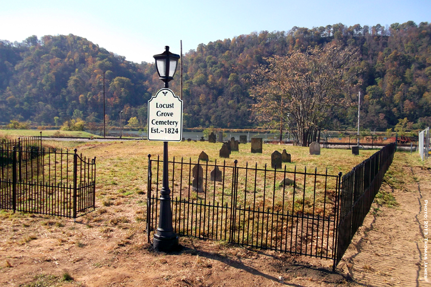
| Description | : | Locust Grove is located within the secure borders of the Dominion Natrium Processing Facility, located about 15 miles south of Moundsville, WV, on State Route 2. The nearest post office is Proctor, WV. This cemetery contains the remains of many pioneer families including one veteran of the Revolutionary War. Thirty-two grave markers have been set upright by employees of Dominion as the company has elected to maintain the yard in a manner befitting consecrated ground. New perimeter fencing, lighting and overall beautification was undertaken and Locust Grove Cemetery was rededicated on 29 October 2013. Members of The Marshall County Historical... Read More |
frequently asked questions (FAQ):
-
Where is Locust Grove Cemetery?
Locust Grove Cemetery is located at Kent, Marshall County ,West Virginia , 26055USA.
-
Locust Grove Cemetery cemetery's updated grave count on graveviews.com?
0 memorials
-
Where are the coordinates of the Locust Grove Cemetery?
Latitude: 39.7566060
Longitude: -80.8618710
Nearby Cemetories:
1. Cedar Curve Cemetery
Kent, Marshall County, USA
Coordinate: 39.7614450, -80.8641560
2. Atkinson-Pioneer Cemetery
Clarington, Monroe County, USA
Coordinate: 39.7674630, -80.8731910
3. Sykes Cemetery
Monroe County, USA
Coordinate: 39.7447014, -80.8783035
4. Mount Sinai Methodist Cemetery
Clarington, Monroe County, USA
Coordinate: 39.7409090, -80.8923190
5. Ollum Cemetery
Monroe County, USA
Coordinate: 39.7259100, -80.8631500
6. Clarington Cemetery
Clarington, Monroe County, USA
Coordinate: 39.7867012, -80.8516998
7. Zesiger Cemetery
Clarington, Monroe County, USA
Coordinate: 39.7575280, -80.9070110
8. Harbison Cemetery
Marshall County, USA
Coordinate: 39.7735600, -80.8213200
9. Walton Cemetery
Monroe County, USA
Coordinate: 39.7907900, -80.8450000
10. Cain Ridge Cemetery
Clarington, Monroe County, USA
Coordinate: 39.7725700, -80.9048200
11. Lude Cemetery
Clarington, Monroe County, USA
Coordinate: 39.7189270, -80.8792370
12. Salem Church Cemetery
Clarington, Monroe County, USA
Coordinate: 39.7422970, -80.9125970
13. Case Cemetery
Clarington, Monroe County, USA
Coordinate: 39.7933080, -80.8901170
14. Rutter Cemetery
Clarington, Monroe County, USA
Coordinate: 39.7505989, -80.9169006
15. Old Case Cemetery
Clarington, Monroe County, USA
Coordinate: 39.7936860, -80.8920400
16. Mount Vernon Cemetery
Clarington, Monroe County, USA
Coordinate: 39.7120207, -80.8634298
17. Saint James Lutheran Cemetery
Clarington, Monroe County, USA
Coordinate: 39.7411820, -80.9238030
18. Doty Cemetery
Marshall County, USA
Coordinate: 39.7921982, -80.8127975
19. Buck Hill Bottom Cemetery
Hannibal, Monroe County, USA
Coordinate: 39.7022980, -80.8412070
20. Mount Union Cemetery
Hannibal, Monroe County, USA
Coordinate: 39.7003500, -80.8839900
21. Fairview Cemetery
Marshall County, USA
Coordinate: 39.7400017, -80.7881012
22. Cameron Cemetery
Cameron, Monroe County, USA
Coordinate: 39.7661855, -80.9412092
23. Zion Methodist Church Cemetery
Clarington, Monroe County, USA
Coordinate: 39.7934100, -80.9289900
24. Old Cameron Cemetery
Cameron, Monroe County, USA
Coordinate: 39.7669750, -80.9468970