
| Memorials | : | 199 |
| Location | : | Lees Creek, Clinton County, USA |
| Coordinate | : | 39.4257400, -83.6551500 |
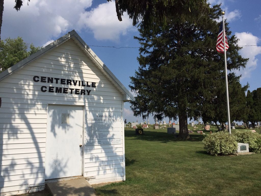
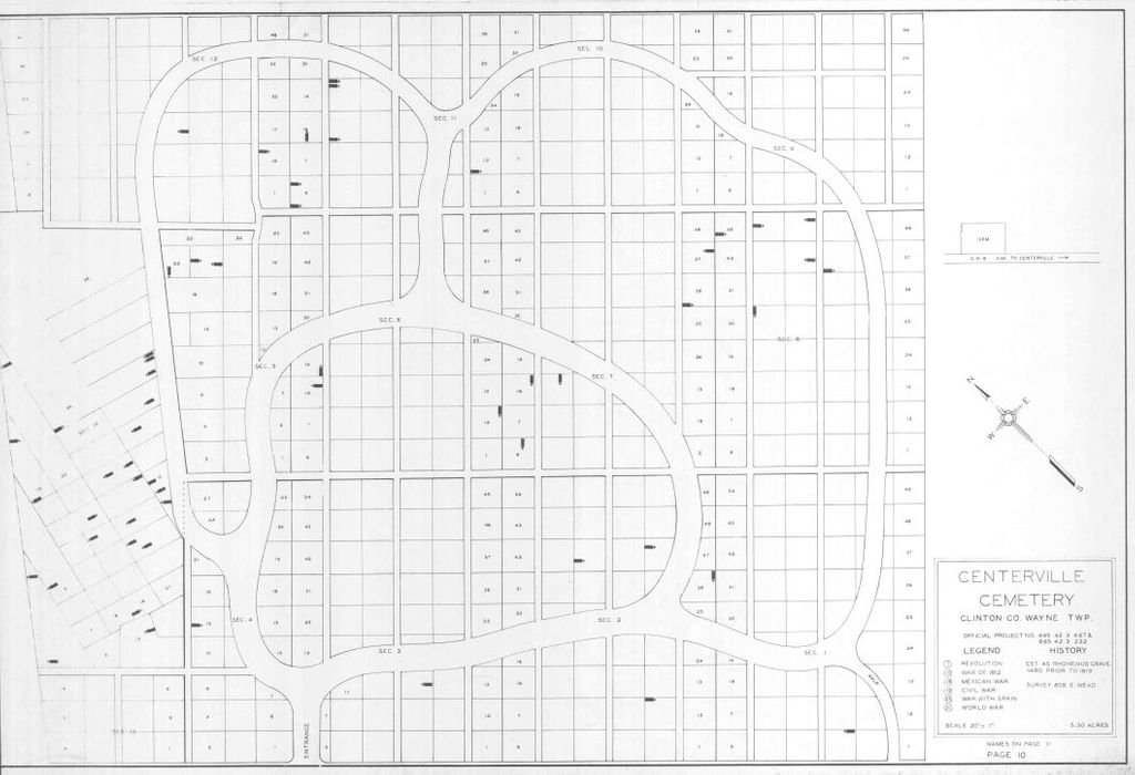
| Description | : | The cemetery is located on the northeast side of Cox Road (County Road 9) about 0.5 miles west of its intersection with Ohio State Route 729. The cemetery is located in Wayne Township, Clinton County, Ohio, and is # 2024 (Centerville Cemetery / Rhonemus Cemetery / Lees Creek Cemetery / Sharpes Cemetery) in “Ohio Cemeteries 1803-2003”, compiled by the Ohio Genealogical Society. The cemetery is registered with the Ohio Division of Real Estate and Professional Licensing (ODRE) as Dozer Cemetery with registration license number CGR.0000981863. The U.S. Geological Survey (USGS) Geographic Names Information System (GNIS) feature ID for... Read More |
frequently asked questions (FAQ):
-
Where is Centerville Cemetery?
Centerville Cemetery is located at Cox Road (County Road 9) Lees Creek, Clinton County ,Ohio , 45169USA.
-
Centerville Cemetery cemetery's updated grave count on graveviews.com?
198 memorials
-
Where are the coordinates of the Centerville Cemetery?
Latitude: 39.4257400
Longitude: -83.6551500
Nearby Cemetories:
1. Zurface Cemetery
Wayne Township, Clinton County, USA
Coordinate: 39.4025750, -83.6256560
2. Terrell Cemetery
Lees Creek, Clinton County, USA
Coordinate: 39.3940201, -83.6402893
3. Richland Cemetery
Wayne Township, Clinton County, USA
Coordinate: 39.4079190, -83.6124410
4. Texas Cemetery
Wayne Township, Clinton County, USA
Coordinate: 39.4371580, -83.7037800
5. Luttrell Cemetery
Wayne Township, Clinton County, USA
Coordinate: 39.4108009, -83.6033020
6. Grove-Geff Cemetery
Wayne Township, Clinton County, USA
Coordinate: 39.4032800, -83.6005800
7. Elliott Cemetery
Wayne Township, Clinton County, USA
Coordinate: 39.3941770, -83.6063710
8. Evans Cemetery
Wayne Township, Clinton County, USA
Coordinate: 39.4516983, -83.6006012
9. Spurgeon Cemetery
Richland Township, Clinton County, USA
Coordinate: 39.4831009, -83.6678009
10. Canney Cemetery
Wayne Township, Clinton County, USA
Coordinate: 39.3876485, -83.5960232
11. Richland Methodist Cemetery
Melvin, Clinton County, USA
Coordinate: 39.4704920, -83.7132380
12. Wade Cemetery
Melvin, Clinton County, USA
Coordinate: 39.4704920, -83.7132380
13. Sabina Cemetery
Sabina, Clinton County, USA
Coordinate: 39.4931183, -83.6418686
14. Polk Family Cemetery
Reesville, Clinton County, USA
Coordinate: 39.4949930, -83.6826460
15. New Antioch Cemetery
New Antioch, Clinton County, USA
Coordinate: 39.4103394, -83.7501984
16. Charles E Fife Farm Cemetery (Defunct)
Wilmington, Clinton County, USA
Coordinate: 39.4307650, -83.7528970
17. Wilson Cemetery
Union Township, Clinton County, USA
Coordinate: 39.4632988, -83.7407990
18. Antioch Cemetery
Fairfield Township, Highland County, USA
Coordinate: 39.3480980, -83.6120280
19. Coulter Cemetery
Wilson Township, Clinton County, USA
Coordinate: 39.5092010, -83.6849976
20. Doan Cemetery
Richland Township, Clinton County, USA
Coordinate: 39.5106010, -83.6243973
21. Swingley Farm Cemetery
Green Township, Clinton County, USA
Coordinate: 39.3475370, -83.7105670
22. Highland Cemetery
Highland, Highland County, USA
Coordinate: 39.3429810, -83.6012330
23. Burnett Cemetery
Highland County, USA
Coordinate: 39.3306007, -83.6619034
24. East Fork Quaker Cemetery
New Vienna, Clinton County, USA
Coordinate: 39.3316000, -83.6968100