
| Memorials | : | 6 |
| Location | : | Panoche, San Benito County, USA |
| Coordinate | : | 36.6150017, -120.9586029 |
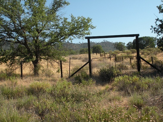
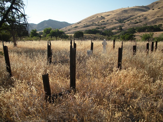
| Description | : | To reach Cherry Hill Cemetery from Hwy 101. Take the Hollister/San Juan Bautista Exit 156 East. Drive 7 miles and turn right on Union Drive. Drive 4 miles and turn right on Airline Hwy/Hwy 25. Drive 12 miles to Paicines and turn left onto Panoche road. Drive 23 miles across the small bridge. The cemetery is on your right side on the hill by the old Cherry Hill School. It is about 35 miles from Hollister. This cemetery is on private property in very poor condition. Cherry Hill Cemetery was considered to be in Fresno County prior to 1874. |
frequently asked questions (FAQ):
-
Where is Cherry Hill Cemetery?
Cherry Hill Cemetery is located at Panoche, San Benito County ,California ,USA.
-
Cherry Hill Cemetery cemetery's updated grave count on graveviews.com?
6 memorials
-
Where are the coordinates of the Cherry Hill Cemetery?
Latitude: 36.6150017
Longitude: -120.9586029
Nearby Cemetories:
1. Willow Creek Cemetery
San Benito County, USA
Coordinate: 36.5957985, -121.1903000
2. Bitterwater Cemetery
Rock Spring Peak, San Benito County, USA
Coordinate: 36.4006004, -120.9916992
3. Paicines Cemetery
Paicines, San Benito County, USA
Coordinate: 36.7088580, -121.2456330
4. San Benito County Cemetery
Hollister, San Benito County, USA
Coordinate: 36.4859009, -121.2306976
5. New Idria Cemetery
Idria, San Benito County, USA
Coordinate: 36.4132380, -120.6724580
6. Soledad Cemetery
Soledad, Monterey County, USA
Coordinate: 36.4275131, -121.3124542
7. Greenfield Cemetery
Greenfield, Monterey County, USA
Coordinate: 36.3347130, -121.2128372
8. Greenfield Holy Trinity Cemetery
Greenfield, Monterey County, USA
Coordinate: 36.3164139, -121.2428131
9. Soledad Mission Cemetery
Soledad, Monterey County, USA
Coordinate: 36.4047460, -121.3561260
10. Saint Benedicts Columbarium
Hollister, San Benito County, USA
Coordinate: 36.8337440, -121.3667120
11. Gonzales Cemetery
Gonzales, Monterey County, USA
Coordinate: 36.4947014, -121.4300003
12. Calvary-Sacred Heart Cemetery
Hollister, San Benito County, USA
Coordinate: 36.8483009, -121.3767014
13. Harper Family Cemetery
Los Banos, Merced County, USA
Coordinate: 37.0215379, -121.1236853
14. Williams-Duckworth Cemetery
Priest Valley, San Benito County, USA
Coordinate: 36.2356600, -120.7100800
15. King City Cemetery
King City, Monterey County, USA
Coordinate: 36.2066078, -121.1374207
16. Odd Fellows Cemetery
Hollister, San Benito County, USA
Coordinate: 36.8571210, -121.4104100
17. Los Banos Cemetery
Los Banos, Merced County, USA
Coordinate: 37.0470200, -120.8547000
18. Calvary Cemetery
Los Banos, Merced County, USA
Coordinate: 37.0486800, -120.8547000
19. Anderson Akers Cemetery
Coalinga, Fresno County, USA
Coordinate: 36.2642690, -120.6226220
20. Dos Palos Cemetery
Dos Palos, Merced County, USA
Coordinate: 36.9831009, -120.6357651
21. Clayton Cemetery
Priest Valley, San Benito County, USA
Coordinate: 36.2028008, -120.7285995
22. Dick Wright
Coalinga, Fresno County, USA
Coordinate: 36.3142452, -120.5319592
23. Long Valley Cemetery
San Lucas, Monterey County, USA
Coordinate: 36.1467700, -120.9545100
24. San Lucas Cemetery
San Lucas, Monterey County, USA
Coordinate: 36.1258354, -121.0134735