
| Memorials | : | 0 |
| Location | : | Coventryville, Chester County, USA |
| Coordinate | : | 40.1831690, -75.6820030 |
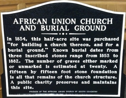
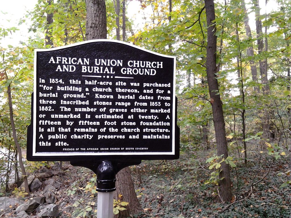
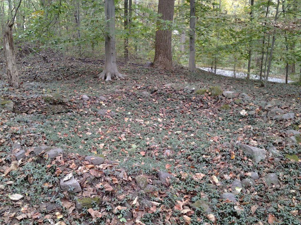
| Description | : | The half-acre site originally was owned by George Chrisman, Ironmaster of Coventry Forge. It was purchased from Chrisman in 1834 for $15 by 5 church trustees: John Williams, John Thomas, George Brown, and William Hinson, all believed to be residents of what was then known as Coventry Township; and Joseph Smith, believed to be a resident of Montgomery County. The church and graveyard have been unattended for decades. The site is largely overgrown, hidden in a small patch of woods off Coventryville Road. Several gravestones and parts of a building foundation remain. Currently the site is maintained by the nonprofit Friends of... Read More |
frequently asked questions (FAQ):
-
Where is Chestnut Hill Union American Methodist Episcopal Cemetery?
Chestnut Hill Union American Methodist Episcopal Cemetery is located at 3181 Coventryville Rd Coventryville, Chester County ,Pennsylvania , 19465USA.
-
Chestnut Hill Union American Methodist Episcopal Cemetery cemetery's updated grave count on graveviews.com?
0 memorials
-
Where are the coordinates of the Chestnut Hill Union American Methodist Episcopal Cemetery?
Latitude: 40.1831690
Longitude: -75.6820030
Nearby Cemetories:
1. Potts Family Cemetery
Coventryville, Chester County, USA
Coordinate: 40.1761670, -75.6837500
2. Coventryville United Methodist Church Cemetery
Coventryville, Chester County, USA
Coordinate: 40.1763000, -75.6908035
3. Pughtown Baptist Church Cemetery
Pughtown, Chester County, USA
Coordinate: 40.1665001, -75.6614990
4. French Creek Seventh Day Baptist Cemetery
Warwick Township, Chester County, USA
Coordinate: 40.1751823, -75.7125854
5. Saint Peter's United Church of Christ Cemetery
Knauertown, Chester County, USA
Coordinate: 40.1735954, -75.7199631
6. Mount Carmel United Methodist Church Cemetery
Warwick Township, Chester County, USA
Coordinate: 40.1911011, -75.7356033
7. Brownback's United Church Of Christ Cemetery
Spring City, Chester County, USA
Coordinate: 40.1760521, -75.6256332
8. Shenkel United Church of Christ Cemetery
North Coventry Township, Chester County, USA
Coordinate: 40.2237473, -75.7042542
9. Nantmeal United Methodist Church Cemetery
Nantmeal Village, Chester County, USA
Coordinate: 40.1418991, -75.7055969
10. Nantmeal Friends Burial Grounds
Nantmeal Village, Chester County, USA
Coordinate: 40.1394440, -75.7066530
11. Sankanac Baptist Cemetery
Warwick Township, Chester County, USA
Coordinate: 40.1783844, -75.7474888
12. Ellis Woods Cemetery
East Coventry Township, Chester County, USA
Coordinate: 40.2033920, -75.6199560
13. Temple United Methodist Cemetery
North Coventry Township, Chester County, USA
Coordinate: 40.2303658, -75.7098541
14. Coventry Church of the Brethren Cemetery
North Coventry Township, Chester County, USA
Coordinate: 40.2313004, -75.6512985
15. Mount Zion Cemetery and Mausoleum
North Coventry Township, Chester County, USA
Coordinate: 40.2335014, -75.6539001
16. Bethel United Methodist Church Cemetery
East Coventry Township, Chester County, USA
Coordinate: 40.1792679, -75.6102676
17. Ebenezer Bible Chapel Cemetery
Warwick Township, Chester County, USA
Coordinate: 40.1593018, -75.7515030
18. East Coventry Mennonite Cemetery
East Coventry Township, Chester County, USA
Coordinate: 40.2234001, -75.6209030
19. Bethesda Baptist Church Cemetery
Warwick Township, Chester County, USA
Coordinate: 40.2034988, -75.7584000
20. East Nantmeal Baptist Cemetery
Nantmeal Village, Chester County, USA
Coordinate: 40.1409912, -75.7511597
21. Saint Andrew's Episcopal Cemetery
Ludwigs Corner, Chester County, USA
Coordinate: 40.1161003, -75.6966019
22. Oak Grove Cemetery
Parker Ford, Chester County, USA
Coordinate: 40.2053600, -75.5973500
23. Old Pottstown Friends Burial Ground
Pottstown, Montgomery County, USA
Coordinate: 40.2465480, -75.6481650
24. Zion Reformed Church Cemetery
Pottstown, Montgomery County, USA
Coordinate: 40.2475900, -75.6498600